Skip to content
Plan & Tour
DestinationsItinerariesTravel BlogAboutContact
0Sign inPlan a trip
Plan & TourPlan & Tour

Travel guides, destination inspiration and curated itineraries for Canada, the USA and beyond, plus a free tool to plan your own day-by-day trip.

Get travel inspiration

Explore

  • All Destinations
  • Curated Itineraries
  • Travel Blog
  • Plan a Trip

Topics

  • Hiking & Nature
  • Food & Drink
  • City Breaks
  • Budget Travel

Company

  • About Us
  • Contact
  • Privacy Policy
  • Terms of Service

© 2026 Plan & Tour. Built for travellers.

Discover the world, one trip at a time.

Revillagigedo Island: Alaska’s Misty Rainforest Gateway
  1. Home
  2. Destinations
  3. Alaska
  4. Revillagigedo Island: Alaska’s Misty Rainforest Gateway
Island

Revillagigedo Island: Alaska’s Misty Rainforest Gateway

Ketchikan's home island offers totem poles, salmon streams, and easy access to the wild fjords of Southeast Alaska.

AlaskaUpdated 13 August 2026

Why Visit Revillagigedo Island

Revillagigedo Island sits in the heart of Southeast Alaska’s temperate rainforest, where steep mountains rise straight from the sea and constant moisture feeds towering spruce and cedar. The island’s main settlement, Ketchikan, serves as the cultural and logistical hub for the region, making the island a natural base for exploring both urban attractions and remote wilderness.

Getting There

Most visitors arrive by air at Ketchikan International Airport on nearby Gravina Island, then take the short ferry across Tongass Narrows. The Alaska Marine Highway System also brings ferries directly to the island’s docks from Juneau, Bellingham, and Prince Rupert. Once on Revillagigedo, a network of roads connects Ketchikan to outlying areas like Saxman and Ward Cove.

Things to Do

Walk the historic boardwalks of Creek Street to see the salmon ladder and former red-light district buildings. Visit the Totem Heritage Center and nearby Saxman Native Village to view one of the largest collections of standing totem poles in the world. Hike the rain-forest trails at Ward Lake or Deer Mountain for glimpses of bald eagles and black bears. Charter boats depart daily for fishing and wildlife viewing in the surrounding waters.

Wildlife and Nature

The island’s streams host runs of pink, chum, and king salmon that draw both anglers and hungry bears. Misty Fjords National Monument lies just east of the island and is best experienced on a day cruise or floatplane flight that reveals sheer granite cliffs and hanging waterfalls.

Best Time to Visit

From May through September the weather is mildest and daylight is longest, allowing full days of outdoor activity. Late summer brings peak salmon runs. Winter months deliver heavy rain and shorter days but fewer crowds and lower ferry traffic.

Nearby Attractions

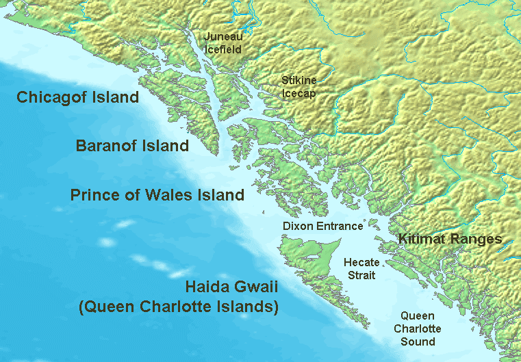
Short ferry rides reach Prince of Wales Island for limestone caves and additional fishing. Floatplane excursions head north to Anan Creek bear observatory or south toward the outer islands of the Alexander Archipelago.

Visitor tips

  • Pack waterproof layers and sturdy boots; the island receives over 150 inches of rain annually.
  • Book Misty Fjords tours and fishing charters in advance during peak summer months.
  • Use the island's free or low-cost bus system to reach trailheads and totem sites without a rental car.

Frequently asked questions

Is Revillagigedo Island the same as Ketchikan?+

Ketchikan occupies the southern end of Revillagigedo Island; the rest of the island is largely undeveloped rainforest accessible by road or boat.

How do I reach Misty Fjords from the island?+

Day cruises and floatplane flights depart from Ketchikan harbors and fly or sail directly into the fjords, typically returning the same day.

Can I see bears on Revillagigedo Island?+

Black bears are common along salmon streams and at the edges of Ketchikan; guided viewing at nearby Anan Creek increases chances of sightings.

Is the island suitable for hiking?+

Yes, maintained trails such as the Deer Mountain Trail and Ward Lake loop offer moderate hikes through old-growth forest with ocean views.

What transportation is available once on the island?+

A public bus system, taxis, and water taxis connect Ketchikan with Saxman, Ward Cove, and trailheads; rental cars are also available at the airport.

Share
Google Maps Apple Maps Directions

Image: en:User:Koba-chan · CC BY-SA 3.0 · via Wikimedia Commons

Keep reading

Nearby & related

All stories
Sagavanirktok River: Rafting Alaska’s Remote Arctic Frontier
North Slope Borough

Sagavanirktok River: Rafting Alaska’s Remote Arctic Frontier

Experience the wild, roadless beauty of one of Alaska’s northernmost rivers on the North Slope.

17 August 2026
Buckland River: Remote Wilderness Fishing in Alaska’s Arctic Frontier
Northwest Arctic Borough

Buckland River: Remote Wilderness Fishing in Alaska’s Arctic Frontier

Paddle, fish, and explore the untouched Buckland River deep in northwest Alaska’s Arctic landscape.

17 August 2026
Gulkana River: Alaska’s Premier Salmon Fishing and Wilderness Float
Southeast Fairbanks Census Area

Gulkana River: Alaska’s Premier Salmon Fishing and Wilderness Float

The Gulkana River delivers remote Alaska wilderness, world-class salmon runs, and scenic multi-day floats in the Copper…

17 August 2026