Skip to content
Plan & Tour
DestinationsItinerariesTravel BlogAboutContact
0Sign inPlan a trip
Plan & TourPlan & Tour

Travel guides, destination inspiration and curated itineraries for Canada, the USA and beyond, plus a free tool to plan your own day-by-day trip.

Get travel inspiration

Explore

  • All Destinations
  • Curated Itineraries
  • Travel Blog
  • Plan a Trip

Topics

  • Hiking & Nature
  • Food & Drink
  • City Breaks
  • Budget Travel

Company

  • About Us
  • Contact
  • Privacy Policy
  • Terms of Service

© 2026 Plan & Tour. Built for travellers.

Discover the world, one trip at a time.

Gravina Island: Wild Shores and Quiet Trails Near Ketchikan
  1. Home
  2. Destinations
  3. Alaska
  4. Gravina Island: Wild Shores and Quiet Trails Near Ketchikan
Island

Gravina Island: Wild Shores and Quiet Trails Near Ketchikan

A short ferry ride from Ketchikan reveals Gravina Island’s old-growth forests, coastal trails, and abundant wildlife within Alaska’s Tongass National Forest.

AlaskaUpdated 14 August 2026

Why Gravina Island Stands Out

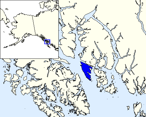
Gravina Island sits directly across the Tongass Narrows from Ketchikan, offering visitors a compact slice of Southeast Alaska wilderness without the crowds of more distant destinations. Its 21-mile length holds dense Sitka spruce and western hemlock forests, rocky beaches, and quiet coves where black bears forage at low tide. The island’s proximity to the mainland makes it an easy day trip or overnight base for travelers who want forest hikes and marine views without flying farther into the backcountry.

Getting There

Most visitors reach Gravina by the short ferry crossing from downtown Ketchikan. The crossing takes roughly 10 minutes and runs frequently during daylight hours. Travelers arriving by air land at the Ketchikan International Airport, which occupies the northern end of the island; a quick shuttle or taxi then connects to the ferry terminal. Those already in Ketchikan simply walk or drive to the waterfront terminal. No bridge currently spans the narrows, so the ferry remains the only public link.

Things to Do

Hiking ranks as the top activity. The Perseverance Trail and the shorter Gravina Island Shoreline Trail provide easy access to old-growth forest and tide-pool viewing. Anglers can cast for salmon and halibut from several public beaches or join small-boat charters that depart from the island’s modest harbors. Wildlife viewing is excellent at dawn and dusk; black bears, bald eagles, and harbor seals are common. Photographers often set up along the western shore for unobstructed views of the Inside Passage and distant Misty Fjords. Kayakers launch from sheltered coves to explore the island’s indented coastline at their own pace.

Best Time to Visit

June through early September offers the mildest weather and longest daylight for hiking and wildlife spotting. July and August bring peak salmon runs, increasing chances of bear sightings. Spring and fall shoulder seasons deliver fewer visitors and dramatic weather changes, while winter travel is possible but limited by short days and frequent storms. Rain gear is essential year-round; Southeast Alaska receives over 150 inches of precipitation annually.

Nearby Attractions

After exploring Gravina, most travelers return to Ketchikan for its totem parks, salmon hatchery, and historic Creek Street. Day cruises into Misty Fjords National Monument depart from Ketchikan and offer a dramatic contrast to the island’s gentler terrain. The Tongass National Forest extends across both islands and the mainland, so the same trail networks and marine life continue beyond Gravina’s shores.

Visitor tips

  • Carry layered rain gear and waterproof footwear; trails remain muddy even on sunny days.
  • Check the ferry schedule the evening before travel, as sailings can shift with tides and weather.
  • Stay at least 100 yards from bears and never approach wildlife for photos.

Frequently asked questions

Do I need a car to explore Gravina Island?+

No. Several trailheads lie within walking distance of the ferry terminal, and the islandu2019s main road is lightly traveled, making it suitable for cyclists or hikers.

Is the famous Bridge to Nowhere still planned?+

The project was canceled years ago. The only connection remains the existing ferry service between Ketchikan and Gravina.

Can I camp on Gravina Island?+

Dispersed camping is allowed within Tongass National Forest boundaries. No developed campgrounds exist, so visitors must pack out all waste and follow Leave No Trace practices.

Are there restaurants or stores on the island?+

Services are minimal. A few small lodges and a general store near the airport serve travelers, but most visitors bring food from Ketchikan.

How far is Gravina Island from Ketchikan?+

The ferry crossing covers less than a mile. Total travel time from downtown Ketchikan is usually under 30 minutes including wait time.

Share
Google Maps Apple Maps Directions

Image: User:Marvin01 · CC BY 2.0 · via Wikimedia Commons

Keep reading

Nearby & related

All stories
Mount Edgecumbe: Hiking Alaska’s Dormant Volcano Near Sitka
Alaska

Mount Edgecumbe: Hiking Alaska’s Dormant Volcano Near Sitka

A rewarding climb to sweeping ocean and island views on Kruzof Island, just west of Sitka.

14 August 2026
Korovin Volcano: Remote Aleutian Island Hiking in Alaska
Alaska

Korovin Volcano: Remote Aleutian Island Hiking in Alaska

Trek the dramatic slopes of this active stratovolcano on Atka Island for unmatched wilderness and volcanic scenery.

14 August 2026
Mount Isto: Alaska’s Remote Brooks Range Summit
Alaska

Mount Isto: Alaska’s Remote Brooks Range Summit

Explore the highest peak in the Brooks Range, a true wilderness adventure deep within the Arctic National Wildlife…

14 August 2026