Skip to content
Plan & Tour
DestinationsItinerariesTravel BlogAboutContact
0Sign inPlan a trip
Plan & TourPlan & Tour

Travel guides, destination inspiration and curated itineraries for Canada, the USA and beyond, plus a free tool to plan your own day-by-day trip.

Get travel inspiration

Explore

  • All Destinations
  • Curated Itineraries
  • Travel Blog
  • Plan a Trip

Topics

  • Hiking & Nature
  • Food & Drink
  • City Breaks
  • Budget Travel

Company

  • About Us
  • Contact
  • Privacy Policy
  • Terms of Service

© 2026 Plan & Tour. Built for travellers.

Discover the world, one trip at a time.

Amatignak Island: A Remote Wilderness Haven in Alaska’s Aleutian Chain
  1. Home
  2. Destinations
  3. Alaska
  4. Amatignak Island: A Remote Wilderness Haven in Alaska’s Aleutian Chain
Island

Amatignak Island: A Remote Wilderness Haven in Alaska’s Aleutian Chain

Discover the untouched beauty, abundant wildlife, and rugged isolation of this far-flung Aleutian island.

AlaskaUpdated 14 August 2026

Why Amatignak Island Stands Out

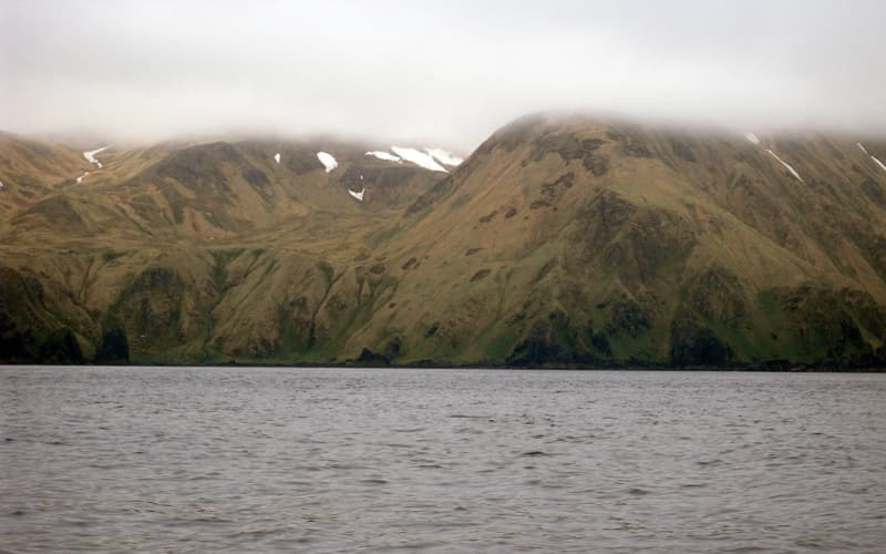
Amatignak Island lies at the western edge of the Andreanof Islands group in Alaska’s Aleutian archipelago. Its steep cliffs, grassy slopes, and sheltered coves support large colonies of seabirds and haul-outs for marine mammals. Because the island is uninhabited and managed within the Alaska Maritime National Wildlife Refuge, visitors encounter an ecosystem that has changed little in centuries.

Reaching the Island

Access begins with a commercial flight to Adak, the nearest settlement with scheduled air service. From Adak, travelers arrange boat charters or floatplane flights for the final leg across open ocean. Weather windows are narrow; captains and pilots monitor marine forecasts closely before departure. Once ashore, movement is by foot only, as no roads or trails exist.

Wildlife and Landscapes to Experience

Northern fur seals and Steller sea lions frequent the rocky beaches, while tufted puffins, black-legged kittiwakes, and thick-billed murres nest on the cliffs. Inland, hikers may spot nesting eagles and Arctic foxes. The island’s highest ridges offer sweeping views of the surrounding Bering Sea and North Pacific, with dramatic changes in light and fog throughout the day.

Best Time to Visit

July and August bring the longest daylight hours and the lowest probability of severe storms. Snow lingers into June on north-facing slopes, and September marks the start of stronger autumn gales. Visitors planning multi-day trips should allow buffer days for weather delays both arriving and departing.

Nearby Destinations

Adak Island provides basic lodging and supplies before or after an Amatignak trip. Further west, the historically significant islands of Kiska and Attu offer additional birding and World War II sites for those extending their Aleutian itinerary. The entire chain rewards travelers who value solitude over convenience.

Visitor tips

  • Pack layers for sudden temperature drops and waterproof gear rated for heavy rain and wind.
  • Carry all food, fuel, and waste-removal supplies; no services exist on the island.
  • File a detailed float plan with local charter operators and carry a satellite communicator.

Frequently asked questions

Do I need a permit to visit Amatignak Island?+

The island is part of a national wildlife refuge; visitors should check current refuge regulations before travel, though day visits for wildlife viewing are generally allowed without special permits.

What kind of wildlife can I expect to see?+

Seabird colonies, seals, and sea lions are the most common sightings; Arctic foxes and nesting raptors may also appear on the tundra slopes.

How long should I plan to stay?+

Most visitors spend two to four days to allow for weather delays and to explore different parts of the coastline and interior ridges.

Is camping possible on the island?+

Yes, but campers must be fully self-sufficient and practice Leave No Trace principles, including packing out all waste.

Are there any facilities or trails?+

There are no maintained trails, shelters, or facilities; navigation relies on maps, GPS, and careful route-finding across open terrain.

Share
Google Maps Apple Maps Directions

Image: D. Sikes from Fairbanks, USA · CC BY-SA 2.0 · via Wikimedia Commons

Keep reading

Nearby & related

All stories
Sagavanirktok River: Rafting Alaska’s Remote Arctic Frontier
North Slope Borough

Sagavanirktok River: Rafting Alaska’s Remote Arctic Frontier

Experience the wild, roadless beauty of one of Alaska’s northernmost rivers on the North Slope.

17 August 2026
Buckland River: Remote Wilderness Fishing in Alaska’s Arctic Frontier
Northwest Arctic Borough

Buckland River: Remote Wilderness Fishing in Alaska’s Arctic Frontier

Paddle, fish, and explore the untouched Buckland River deep in northwest Alaska’s Arctic landscape.

17 August 2026
Gulkana River: Alaska’s Premier Salmon Fishing and Wilderness Float
Southeast Fairbanks Census Area

Gulkana River: Alaska’s Premier Salmon Fishing and Wilderness Float

The Gulkana River delivers remote Alaska wilderness, world-class salmon runs, and scenic multi-day floats in the Copper…

17 August 2026