Skip to content
Plan & Tour
DestinationsItinerariesTravel BlogAboutContact
0Sign inPlan a trip
Plan & TourPlan & Tour

Travel guides, destination inspiration and curated itineraries for Canada, the USA and beyond, plus a free tool to plan your own day-by-day trip.

Get travel inspiration

Explore

  • All Destinations
  • Curated Itineraries
  • Travel Blog
  • Plan a Trip

Topics

  • Hiking & Nature
  • Food & Drink
  • City Breaks
  • Budget Travel

Company

  • About Us
  • Contact
  • Privacy Policy
  • Terms of Service

© 2026 Plan & Tour. Built for travellers.

Discover the world, one trip at a time.

Urir Char: Bangladesh’s Remote Island Escape in Chattogram
  1. Home
  2. Destinations
  3. Chattogram Division
  4. Urir Char: Bangladesh’s Remote Island Escape in Chattogram
Island

Urir Char: Bangladesh’s Remote Island Escape in Chattogram

Experience the quiet beaches, fishing villages, and natural landscapes of Urir Char, a silt-formed island in the Bay of Bengal.

Chattogram DivisionUpdated 24 September 2026

Discovering Urir Char

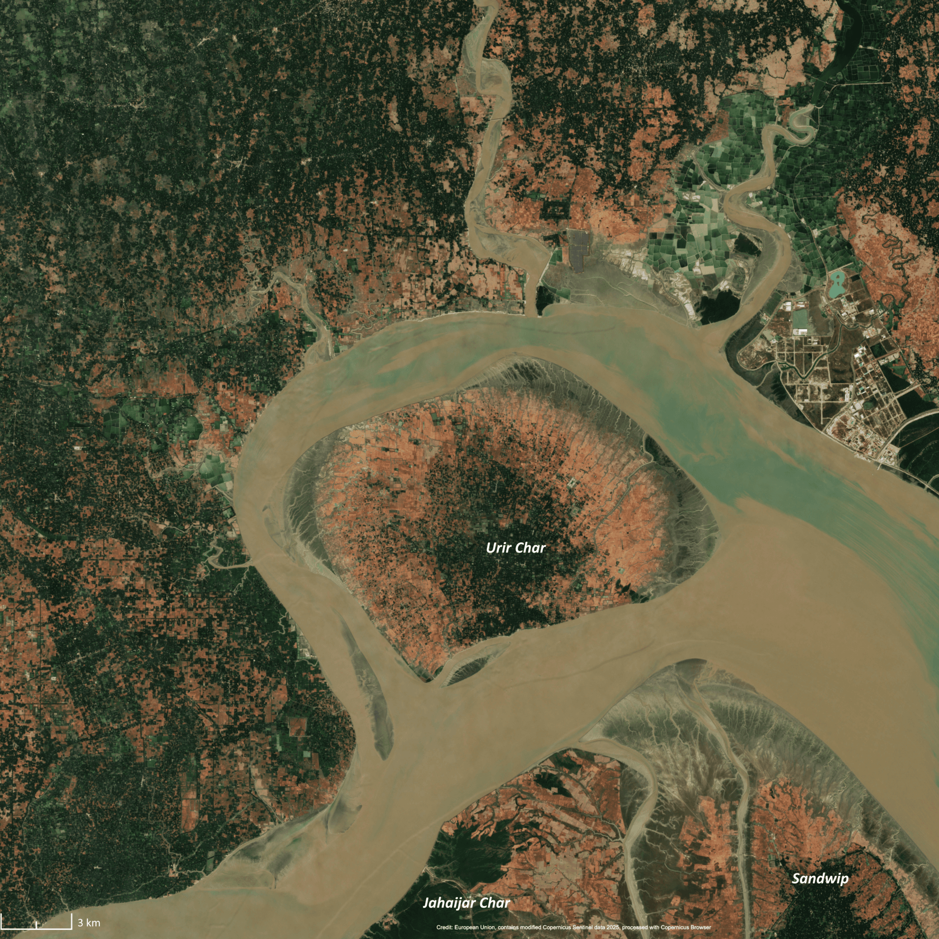
Urir Char sits in the shallow waters off Chattogram Division, formed over decades by sediment from the Meghna River. Its wide tidal flats and low dunes create a landscape shaped by the sea rather than tourism. Visitors find long stretches of empty beach, scattered coconut palms, and small settlements where fishing remains the main livelihood.

Local Life and Landscape

The island’s interior holds modest paddy fields and mangrove fringes that shelter crabs, wading birds, and occasional winter migrants. At low tide, villagers walk the exposed flats to collect shellfish, giving travelers a direct view of daily rhythms unchanged by mainland development.

How to Reach Urir Char

Most travelers start from Chattogram city and take a launch or speedboat to Sandwip Island, then continue by local boat to Urir Char. The final leg crosses open water and can be affected by tides, so departures are often timed with the morning high tide. From Sandwip’s ghat, wooden boats make the short crossing in roughly one hour when conditions allow.

Best Time to Visit

The driest months, November through February, bring calmer seas and comfortable temperatures for walking and boat travel. March and April can still be pleasant, though pre-monsoon storms begin to appear. The June-to-September monsoon brings heavy rain and rough water that often cancels boat services.

Things to Do

  • Walk the eastern beach at sunrise to watch fishing boats return with the catch.
  • Join a local boat for a slow circuit around the island’s mangrove edges, where kingfishers and egrets are common.
  • Observe traditional net-mending and boat-building in the hamlets near the main landing point.
  • Watch the dramatic tidal shift that turns wide sand flats into shallow channels within a few hours.

Where to Stay and Eat

Accommodation is limited to a handful of simple guesthouses and homestays run by island families. Expect basic rooms with fans and shared bathrooms. Meals center on fresh seafood—usually rice, dal, and whatever fish or shrimp the boats bring in that day. Visitors who prefer more comfort return to Sandwip or Chattogram each evening.

Nearby Places Worth Exploring

Sandwip Island offers larger markets and historic sites for those extending the trip. Further north, the chars near Hatiya provide similar coastal scenery on a bigger scale. On the mainland, the beaches and shipbreaking yards around Sitakunda give context to the region’s maritime character.

Visitor tips

  • Bring cash; ATMs are absent on the island and mobile networks can be unreliable.
  • Check tide tables and boat schedules the day before travel, as crossings depend on water levels.
  • Pack reef-safe sunscreen, a hat, and sturdy sandalsu2014sand and mud paths become hot and slippery at midday.

Frequently asked questions

Is Urir Char safe for solo travelers?+

The island is peaceful, but its isolation means visitors should inform someone of their plans and travel with a local guide or boatman for the crossings.

What should I pack for a day trip to Urir Char?+

Water, snacks, a light jacket for boat rides, and any personal medications, since shops stock only basic items.

Can I swim at the beaches?+

The water is shallow and tidal currents can be strong; most visitors wade rather than swim far from shore.

Are there any protected areas or entry fees on the island?+

No formal protected zones or fees exist; respect village boundaries and avoid disturbing nesting birds along the shore.

How long should I plan to stay?+

A single full day allows time to walk the main beach and visit one or two villages; overnight stays suit those wanting to experience sunrise and sunset tides.

Share
Google Maps Apple Maps Directions

Image: Copernicus, image satellite Sentinel-2A · CC BY 3.0 · via Wikimedia Commons

Keep reading

Nearby & related

All stories
T
Chattogram Division

Tangiodaung: Trekking Bangladesh’s Remote Chattogram Mountain

A quiet summit in the Chittagong Hill Tracts offering sweeping views, forest trails, and a glimpse of indigenous hill…

26 September 2026
T
Chattogram Division

Tailang Taung: Trekking Bangladesh’s Remote Chittagong Hill Peaks

Discover hiking trails, sweeping views, and quiet indigenous villages on this lesser-known mountain in Chattogram…

26 September 2026
K
Chattogram Division

Kongkoni Taung: Trekking the Remote Peaks of Bangladesh’s Chittagong Hill Tracts

Discover the rugged trails, sweeping views, and indigenous cultures that define this lesser-known mountain in Chattogram…

26 September 2026