Skip to content
Plan & Tour
DestinationsItinerariesTravel BlogAboutContact
0Sign inPlan a trip
Plan & TourPlan & Tour

Travel guides, destination inspiration and curated itineraries for Canada, the USA and beyond, plus a free tool to plan your own day-by-day trip.

Get travel inspiration

Explore

  • All Destinations
  • Curated Itineraries
  • Travel Blog
  • Plan a Trip

Topics

  • Hiking & Nature
  • Food & Drink
  • City Breaks
  • Budget Travel

Company

  • About Us
  • Contact
  • Privacy Policy
  • Terms of Service

© 2026 Plan & Tour. Built for travellers.

Discover the world, one trip at a time.

Tunupa Volcano: Hiking Bolivia’s Striking Andean Peak Near Salar de Uyuni
  1. Home
  2. Destinations
  3. Potosí Department
  4. Tunupa Volcano: Hiking Bolivia’s Striking Andean Peak Near Salar de Uyuni
Mountain

Tunupa Volcano: Hiking Bolivia’s Striking Andean Peak Near Salar de Uyuni

Climb the dormant Tunupa volcano for sweeping views over the world’s largest salt flat and the stark altiplano of Potosí.

Potosí DepartmentUpdated 12 October 2026

Why Tunupa Volcano Stands Out

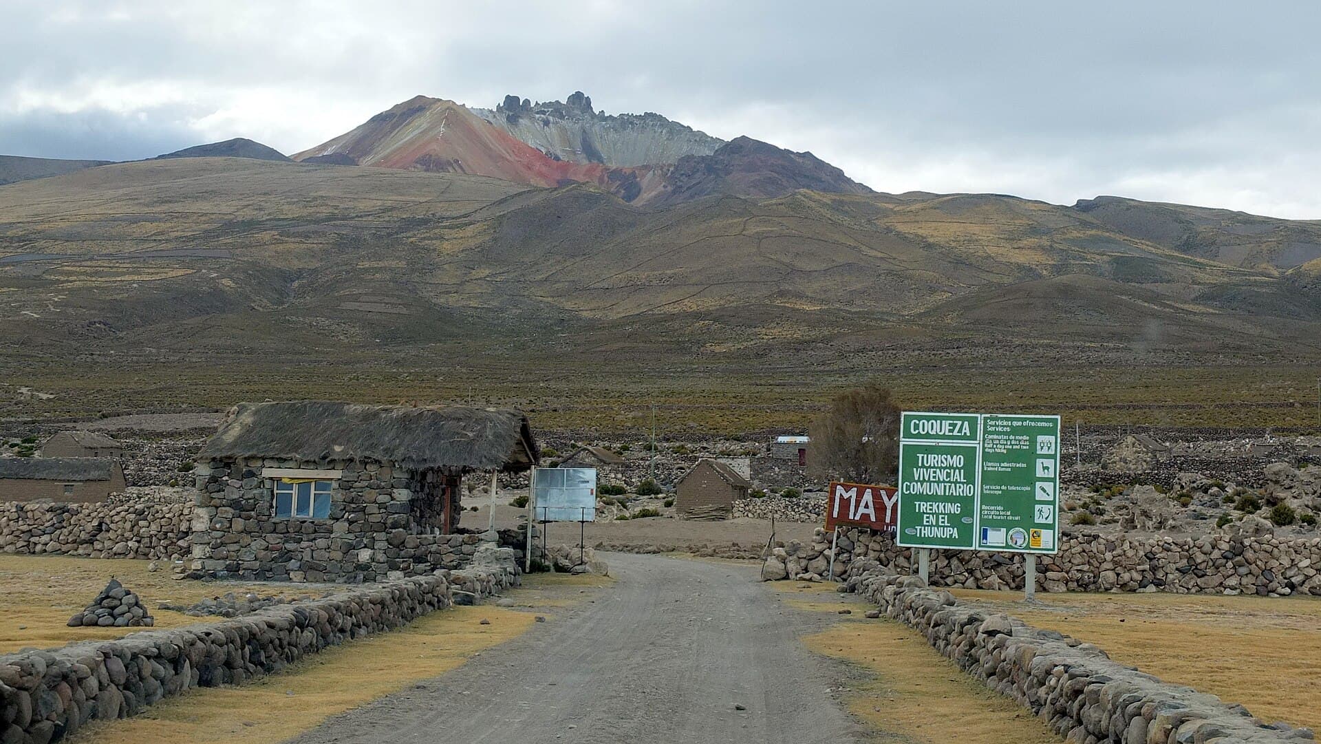
Tunupa rises dramatically from the flat expanse of southwestern Bolivia, its symmetrical cone offering a rare combination of accessible high-altitude hiking and unobstructed vistas across the Salar de Uyuni. At roughly 5,300 meters, the volcano sits in a remote corner of Potosí Department where the landscape shifts from blinding white salt crust to dark volcanic rock and scattered quinoa fields tended by local Aymara communities.

Climbing Routes and Summit Views

Most visitors tackle the standard southwest ridge, a non-technical ascent that begins from a trailhead near the village of Jirira. The route winds past ancient lava flows and hardy ichu grass before reaching the crater rim, where the entire Salar de Uyuni spreads out like a vast mirror on clear days. On the northern side, smaller craters and fumarolic deposits create an otherworldly foreground for photography. The round-trip hike typically takes six to eight hours for fit travelers.

How to Reach Tunupa

The volcano lies roughly 100 kilometers northwest of Uyuni town. Most travelers join a 4×4 tour that combines the salt flat with an overnight stop near Tunupa; independent visitors need a high-clearance vehicle and should arrange fuel and permits in Uyuni. The final approach follows a rough dirt track that can become impassable after heavy rain.

Best Time to Visit

The dry season from May through October brings stable weather, crisp visibility, and minimal risk of afternoon thunderstorms. June and July nights drop well below freezing, so layered clothing and a quality sleeping bag are essential for any overnight camp. The wet months of December to March can make access roads muddy and obscure summit views with cloud.

Nearby Attractions Worth Combining

Many itineraries link Tunupa with the salt-flat sunrise at Isla Incahuasi, the colonial mining town of Potosí, or the thermal springs at Polques. The surrounding altiplano also hosts pink flamingo colonies at smaller lakes and pre-Inca ruins scattered across the pampa.

Practical Considerations for the Altiplano

  • Altitude sickness is common; spend at least one night in Uyuni before attempting the climb.
  • Carry more water than you think you need; sources are scarce above the trailhead.
  • Respect local grazing lands and ask permission before camping near village boundaries.

Visitor tips

  • Acclimatize in Uyuni for 24u201348 hours before hiking to reduce altitude-sickness risk.
  • Hire a local driver or guide familiar with the unmarked final track; GPS alone is unreliable.
  • Pack sun protection and warm layersu2014UV is intense and temperatures swing sharply between day and night.

Frequently asked questions

How difficult is the hike up Tunupa Volcano?+

The southwest ridge is a strenuous but non-technical walk on loose volcanic gravel; most reasonably fit hikers complete it in a long day with an early start.

Do I need a guide or permit to climb Tunupa?+

No formal permit is required, but hiring a local driver or guide is strongly recommended for navigation and safety on the remote approach roads.

Can I combine Tunupa with a Salar de Uyuni tour?+

Yesu2014most multi-day salt-flat tours include an optional Tunupa side trip or overnight near the volcanou2019s base.

What should I bring for the summit day?+

Plenty of water, sun hat, sunscreen, windproof jacket, gloves, and snacks; there are no facilities above the trailhead.

Is Tunupa suitable for beginners or families?+

The altitude and long ascent make it unsuitable for young children or anyone not already acclimatized to high elevation.

Share
Google Maps Apple Maps Directions

Image: Albert Backer · CC BY-SA 3.0 · via Wikimedia Commons

Keep reading

Nearby & related

All stories
S
Potosí Department

Sabaya River: Bolivia’s Remote Highland Waterway in Potosí

Discover the stark Andean beauty and quiet isolation of the Sabaya River in Bolivia’s high desert.

13 October 2026
L
Potosí Department

Laguna Charcota: Remote Turquoise Lake in Bolivia’s Andean Highlands

Explore the striking high-altitude waters and stark volcanic scenery of Laguna Charcota deep in Potosí Department.

12 October 2026
S
Potosí Department

Silala River: Remote Andean Waters in Bolivia’s Potosí Department

Explore the high-altitude springs and wetlands of the Silala River, a striking natural feature on Bolivia’s border with…

12 October 2026