Skip to content
Plan & Tour
DestinationsItinerariesTravel BlogAboutContact
0Sign inPlan a trip
Plan & TourPlan & Tour

Travel guides, destination inspiration and curated itineraries for Canada, the USA and beyond, plus a free tool to plan your own day-by-day trip.

Get travel inspiration

Explore

  • All Destinations
  • Curated Itineraries
  • Travel Blog
  • Plan a Trip

Topics

  • Hiking & Nature
  • Food & Drink
  • City Breaks
  • Budget Travel

Company

  • About Us
  • Contact
  • Privacy Policy
  • Terms of Service

© 2026 Plan & Tour. Built for travellers.

Discover the world, one trip at a time.

Tanaga Mountain: Hiking Alaska’s Remote Aleutian Volcano
  1. Home
  2. Destinations
  3. Alaska
  4. Tanaga Mountain: Hiking Alaska’s Remote Aleutian Volcano
Mountain

Tanaga Mountain: Hiking Alaska’s Remote Aleutian Volcano

Discover the rugged trails, volcanic landscapes, and abundant wildlife of this isolated peak in the Aleutian Islands.

AlaskaUpdated 13 August 2026

Why Visit Tanaga Mountain

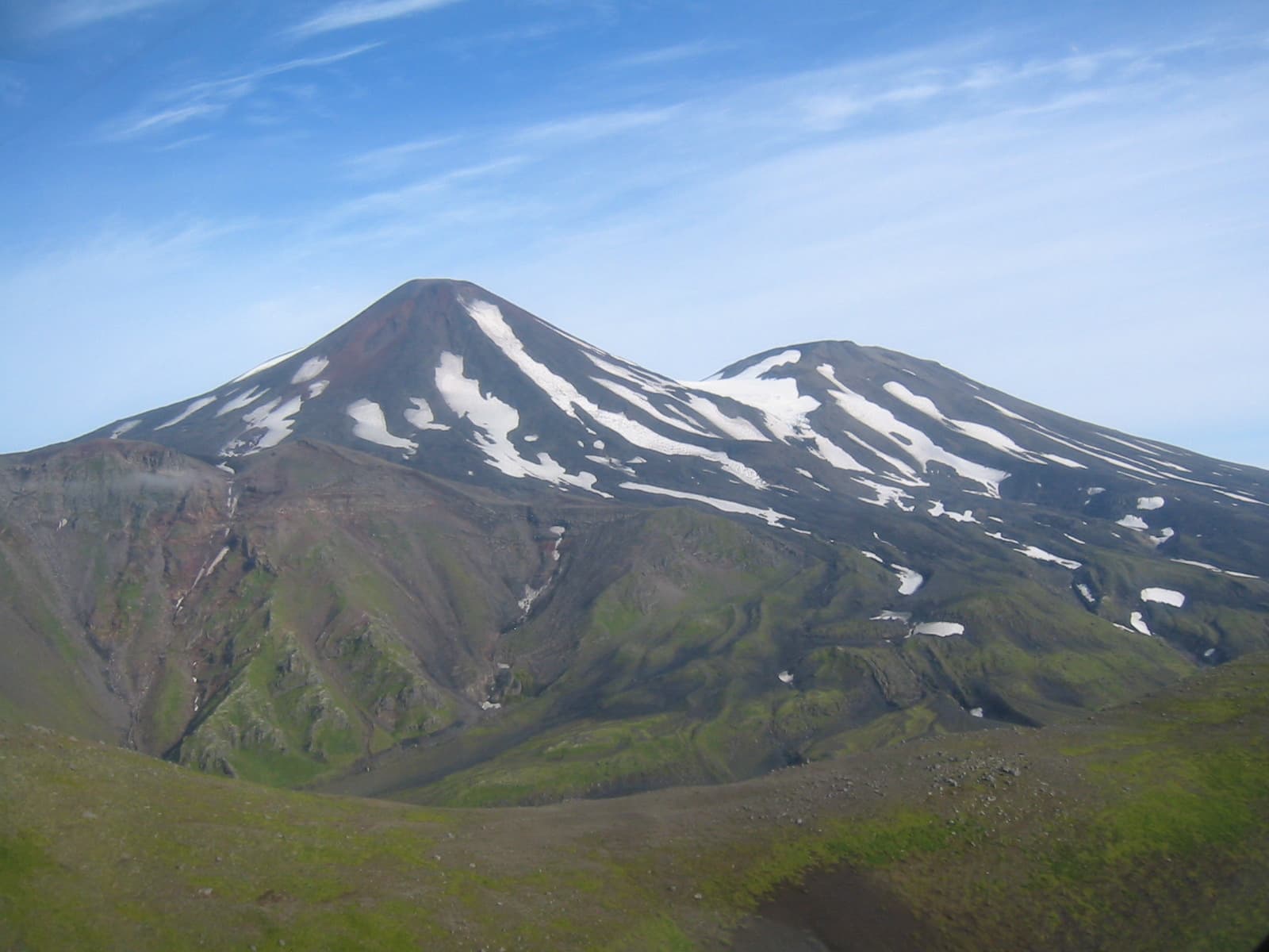
Tanaga Mountain rises dramatically from the northern shore of Tanaga Island in the western Aleutian chain. Its symmetrical cone and surrounding crater lakes offer hikers a rare chance to explore an active stratovolcano in one of North America’s most pristine wildlife refuges. The island’s complete lack of roads or settlements means visitors experience true wilderness, with sweeping views across the North Pacific and frequent sightings of seabirds, sea otters, and harbor seals.

How to Reach Tanaga Island

Access begins with a commercial flight to Adak or Dutch Harbor on the Aleutian chain. From there, travelers arrange floatplane or small-boat charters that land on the island’s sheltered bays. The crossing can take several hours and is weather-dependent; experienced local pilots and captains are essential for safe passage through the region’s frequent fog and strong winds.

Best Time to Go

July through early September brings the longest daylight, mildest temperatures, and lowest chance of snow on the upper slopes. Outside this window, persistent storms and shorter days make travel and camping far more demanding.

Activities on and Around the Mountain

  • Day hikes along established game trails that ascend through lush maritime tundra to the crater rim.
  • Wildlife observation from coastal campsites, where northern fulmars, puffins, and kittiwakes nest in large colonies.
  • Photography of steaming fumaroles and turquoise crater lakes that dot the upper elevations.
  • Sea-kayaking in protected coves when weather permits, offering close encounters with marine mammals.

Nearby Highlights

Just west of Tanaga lies the even more remote Gareloi Island, another volcanic peak with dramatic sea cliffs. Eastward, the historic World War II sites on Adak provide cultural contrast after days spent in pure wilderness. The entire island group forms part of the Alaska Maritime National Wildlife Refuge, protecting millions of seabirds and unique plant communities found nowhere else in the United States.

Practical Considerations

Visitors must be fully self-sufficient. Bring sturdy tents, bear-resistant food storage, and layers for sudden temperature drops. Cell coverage is nonexistent; satellite messengers or VHF radios are standard safety equipment. All waste must be packed out to preserve the island’s fragile ecology.

Visitor tips

  • Charter operators in Adak or Dutch Harbor require advance booking and detailed weather briefings; flexibility of several days is essential.
  • Carry bear spray and practice proper food storage; brown bears are present on Tanaga Island despite its isolation.
  • File a detailed itinerary with the Alaska Maritime National Wildlife Refuge office before departure to aid any potential search-and-rescue efforts.

Frequently asked questions

Do I need a permit to hike Tanaga Mountain?+

No special hiking permit is required, but visitors should register with the U.S. Fish and Wildlife Service office in Homer or Adak so refuge staff know who is on the island.

Is Tanaga Mountain an active volcano?+

The mountain is classified as potentially active; the last confirmed eruption occurred in the early 20th century. Current monitoring shows low-level fumarolic activity, so hikers should avoid obvious steam vents.

How difficult is the climb to the summit?+

The ascent involves steep, unmaintained tundra slopes and loose volcanic scree; it is suitable only for experienced hikers comfortable with route-finding and sudden weather changes.

What wildlife might I encounter?+

Expect seabird colonies, sea otters, harbor seals, and occasional brown bears. Whales can sometimes be seen from the shoreline during summer months.

Can I camp near the mountain?+

Yes, established campsites exist along the northern coastline. Choose sites above the high-tide line and at least 100 yards from any fresh water to protect the islandu2019s resources.

Share
Google Maps Apple Maps Directions

Image: M. L. Coombs · Public domain · via Wikimedia Commons

Keep reading

Nearby & related

All stories
Sagavanirktok River: Rafting Alaska’s Remote Arctic Frontier
North Slope Borough

Sagavanirktok River: Rafting Alaska’s Remote Arctic Frontier

Experience the wild, roadless beauty of one of Alaska’s northernmost rivers on the North Slope.

17 August 2026
Buckland River: Remote Wilderness Fishing in Alaska’s Arctic Frontier
Northwest Arctic Borough

Buckland River: Remote Wilderness Fishing in Alaska’s Arctic Frontier

Paddle, fish, and explore the untouched Buckland River deep in northwest Alaska’s Arctic landscape.

17 August 2026
Gulkana River: Alaska’s Premier Salmon Fishing and Wilderness Float
Southeast Fairbanks Census Area

Gulkana River: Alaska’s Premier Salmon Fishing and Wilderness Float

The Gulkana River delivers remote Alaska wilderness, world-class salmon runs, and scenic multi-day floats in the Copper…

17 August 2026