Skip to content
Plan & Tour
DestinationsItinerariesTravel BlogAboutContact
0Sign inPlan a trip
Plan & TourPlan & Tour

Travel guides, destination inspiration and curated itineraries for Canada, the USA and beyond, plus a free tool to plan your own day-by-day trip.

Get travel inspiration

Explore

  • All Destinations
  • Curated Itineraries
  • Travel Blog
  • Plan a Trip

Topics

  • Hiking & Nature
  • Food & Drink
  • City Breaks
  • Budget Travel

Company

  • About Us
  • Contact
  • Privacy Policy
  • Terms of Service

© 2026 Plan & Tour. Built for travellers.

Discover the world, one trip at a time.

Gareloi Island: Remote Volcanic Wilderness in Alaska’s Aleutians
  1. Home
  2. Destinations
  3. Aleutians West Census Area
  4. Gareloi Island: Remote Volcanic Wilderness in Alaska’s Aleutians
Island

Gareloi Island: Remote Volcanic Wilderness in Alaska’s Aleutians

This uninhabited Aleutian island offers dramatic volcano hikes, seabird colonies, and true wilderness for prepared adventurers.

Aleutians West Census AreaUpdated 14 August 2026

Why Gareloi Island Rewards the Journey

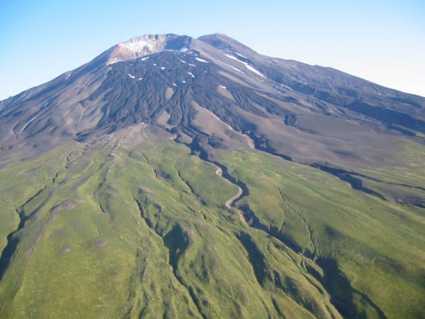
Gareloi Island sits in the western Aleutian chain, a 10-kilometer-wide stratovolcano rising sharply from the Bering Sea. Its isolation preserves one of Alaska’s most intact volcanic landscapes, free of roads, settlements, or commercial development. Visitors come for the raw geology, massive seabird colonies, and the sense of standing on a frontier few ever reach.

Geology and the Active Volcano

The island’s centerpiece is Gareloi Volcano, which rises 1,573 meters and has erupted multiple times in the past century. Steam vents and colorful mineral deposits mark recent activity on the upper slopes. Lava fields and cinder cones cover the southern half, while northern cliffs plunge directly into the ocean. These features create a compact laboratory of volcanic landforms that can be explored on foot during clear weather windows.

Wildlife and Marine Life

More than 100,000 seabirds nest on the steep cliffs each summer. Tufted puffins, least auklets, and northern fulmars dominate the colonies. Harbor seals and Steller sea lions haul out on rocky beaches, and occasional gray whales pass through the surrounding waters. The island forms part of the Alaska Maritime National Wildlife Refuge, so all wildlife must be viewed from a respectful distance.

Getting to Gareloi Island

Access begins with a flight to Adak or Dutch Harbor, followed by a multi-day boat charter or small-plane drop-off. Weather windows dictate all travel; pilots and skippers wait for calm seas and clear skies. Once on the island, visitors must be fully self-sufficient with tents, food, and emergency communication gear.

Best Time to Visit

June through early September offers the longest daylight and mildest temperatures. Snow lingers on higher slopes into July, and frequent fog can ground planes or delay boats for days. Outside this window, winter storms and darkness make visits impractical.

Activities on the Island

  • Day hikes to the crater rim when visibility allows, following established game trails.
  • Coastal walks to observe seal haul-outs and cliff-nesting birds.
  • Photography of steam vents, lava flows, and the dramatic coastline.
  • Wilderness camping on sheltered gravel beaches.

Permits are required through the U.S. Fish and Wildlife Service for any overnight stay.

Visitor tips

  • Carry extra food and fuel; weather delays of several days are common.
  • Travel only with operators experienced in Aleutian conditions and satellite communication.
  • Pack layers for rapid weather changes and waterproof everything.

Frequently asked questions

Is Gareloi Island inhabited?+

No permanent residents live on the island; it is managed entirely as wildlife refuge.

Can I hike to the summit of Gareloi Volcano?+

The crater rim is reachable on foot during good weather, but the route involves loose scree and requires mountaineering awareness.

How long should I plan to stay?+

Most visitors spend three to seven days to allow for weather and to explore multiple areas of the island.

Are there any facilities or trails?+

There are no maintained trails, shelters, or services; everything must be carried in and out.

What nearby islands can I combine with a visit?+

Charters often include Tanaga Island or the Delarof Islands for additional wildlife viewing.

Share
Google Maps Apple Maps Directions

Image: Michelle L. Coombs (USGS) · Public domain · via Wikimedia Commons

Keep reading

Nearby & related

All stories
H
Aleutians West Census Area

Hammerhead Island: Remote Wilderness in Alaska’s Aleutian Chain

Experience the raw, windswept isolation and abundant marine wildlife of this uninhabited Aleutian island.

16 August 2026
L
Aleutians West Census Area

Little Kiska Island: Remote Aleutian Wilderness and WWII History

Discover the untouched landscapes, seabird colonies, and wartime relics of this isolated island in Alaska’s Aleutian…

16 August 2026
A
Aleutians West Census Area

Aziak Island: Remote Wilderness in Alaska’s Aleutian Chain

This isolated island in the central Aleutians delivers raw volcanic landscapes, seabird colonies, and true frontier…

16 August 2026