Skip to content
Plan & Tour
DestinationsItinerariesTravel BlogAboutContact
0Sign inPlan a trip
Plan & TourPlan & Tour

Travel guides, destination inspiration and curated itineraries for Canada, the USA and beyond, plus a free tool to plan your own day-by-day trip.

Get travel inspiration

Explore

  • All Destinations
  • Curated Itineraries
  • Travel Blog
  • Plan a Trip

Topics

  • Hiking & Nature
  • Food & Drink
  • City Breaks
  • Budget Travel

Company

  • About Us
  • Contact
  • Privacy Policy
  • Terms of Service

© 2026 Plan & Tour. Built for travellers.

Discover the world, one trip at a time.

Storm Mountain: Hiking the Rugged Peak in Kootenay National Park
  1. Home
  2. Destinations
  3. British Columbia
  4. Storm Mountain: Hiking the Rugged Peak in Kootenay National Park
Mountain

Storm Mountain: Hiking the Rugged Peak in Kootenay National Park

Experience dramatic Rocky Mountain views and rewarding alpine hiking on Storm Mountain in British Columbia.

British ColumbiaUpdated 8 August 2026

Why Storm Mountain Stands Out

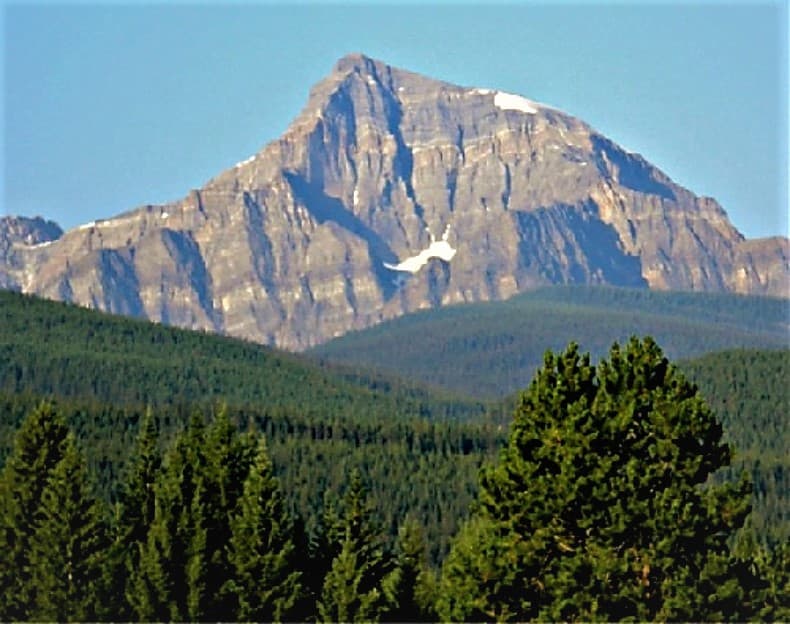
Storm Mountain rises prominently in the Vermilion Range within Kootenay National Park, offering hikers sweeping vistas across the Kootenay River valley and distant peaks of the Canadian Rockies. Its accessible yet challenging trails attract those seeking solitude away from busier Banff-area summits while delivering classic high-alpine scenery.

Reaching Storm Mountain

Access begins along Highway 93, the scenic north-south route through Kootenay National Park. Park at the designated trailhead pullout and follow the well-marked path that climbs steadily through subalpine forest before opening onto rocky slopes and meadows. The approach requires a vehicle and a valid national park pass; no shuttle service operates to this trailhead.

Best Time to Visit

July through early September provides the most reliable snow-free conditions on upper slopes and the clearest weather for photography. Early summer brings wildflowers in lower meadows, while September often delivers crisp air and fewer visitors. Always check avalanche forecasts in shoulder seasons and prepare for sudden temperature drops at elevation.

Activities and Trails

The primary route follows an old fire road then a narrow trail to the summit ridge, rewarding climbers with 360-degree views of the Rockwall and Mount Assiniboine on clear days. Shorter options include forest walks near the trailhead or ridge-line exploration without reaching the true summit. Wildlife viewing for mountain goats and hoary marmots is common along the route.

Photography and Safety

Carry layers for wind and rain, sturdy boots for loose scree, and plenty of water. The exposed upper sections demand careful footing and awareness of changing weather. No facilities exist beyond the trailhead, so plan self-sufficient day trips.

Nearby Destinations

Combine a visit with stops at Marble Canyon, the Paint Pots, or the Radium Hot Springs pools along the same highway corridor. Further afield, the Icefields Parkway and Yoho National Park offer additional alpine scenery within a half-day drive.

Visitor tips

  • Pack bear spray and know how to use it, as black and grizzly bears frequent the area.
  • Start early to avoid afternoon thunderstorms common in the Rockies.
  • Download offline maps, as cell service is unreliable once you leave the highway.

Frequently asked questions

How difficult is the hike to Storm Mountain summit?+

The route involves steady elevation gain on rocky terrain and is best suited to experienced hikers comfortable with route-finding and exposure.

Do I need a permit to hike Storm Mountain?+

A national park pass is required for entry to Kootenay National Park; no additional hiking permit is needed for day use.

Is Storm Mountain suitable for families?+

The lower sections offer pleasant forest walks, but the full summit push is too strenuous and exposed for most children.

What wildlife might I encounter?+

Expect possible sightings of mountain goats, marmots, and bears; maintain distance and store food properly.

Are there camping options near Storm Mountain?+

Backcountry camping is available at designated sites within the park, but reservations and permits are required in advance.

Share
Google Maps Apple Maps Directions

Image: Ron Clausen · CC BY-SA 4.0 · via Wikimedia Commons

Keep reading

Nearby & related

All stories
Wedgemount Lake: Hiking to a Turquoise Alpine Gem Near Whistler
British Columbia

Wedgemount Lake: Hiking to a Turquoise Alpine Gem Near Whistler

A rewarding backcountry trek leads to glacial waters and sweeping mountain views in British Columbia’s Coast Range.

8 August 2026
Yellowhead Lake: Turquoise Waters and Mountain Backdrops in Mount Robson Provincial Park
British Columbia

Yellowhead Lake: Turquoise Waters and Mountain Backdrops in Mount Robson Provincial Park

This serene lake in British Columbia’s Rockies delivers quiet paddling, trout fishing, and easy access to dramatic peaks…

8 August 2026
Swindle Island: Remote Wilderness on British Columbia’s Central Coast
British Columbia

Swindle Island: Remote Wilderness on British Columbia’s Central Coast

Discover pristine rainforest, marine wildlife, and quiet anchorages on this secluded island in the Inside Passage.

8 August 2026


