Skip to content
Plan & Tour
DestinationsItinerariesTravel BlogAboutContact
0Sign inPlan a trip
Plan & TourPlan & Tour

Travel guides, destination inspiration and curated itineraries for Canada, the USA and beyond, plus a free tool to plan your own day-by-day trip.

Get travel inspiration

Explore

  • All Destinations
  • Curated Itineraries
  • Travel Blog
  • Plan a Trip

Topics

  • Hiking & Nature
  • Food & Drink
  • City Breaks
  • Budget Travel

Company

  • About Us
  • Contact
  • Privacy Policy
  • Terms of Service

© 2026 Plan & Tour. Built for travellers.

Discover the world, one trip at a time.

Olca Volcano: Hiking Bolivia’s Remote Andean Stratovolcano
  1. Home
  2. Destinations
  3. Nor Lípez Province
  4. Olca Volcano: Hiking Bolivia’s Remote Andean Stratovolcano
Mountain

Olca Volcano: Hiking Bolivia’s Remote Andean Stratovolcano

A guide to reaching, exploring, and understanding Olca, the striking 5,407-meter volcano on Bolivia’s western Altiplano.

Nor Lípez ProvinceUpdated 11 October 2026

Why Olca Draws Serious Travelers

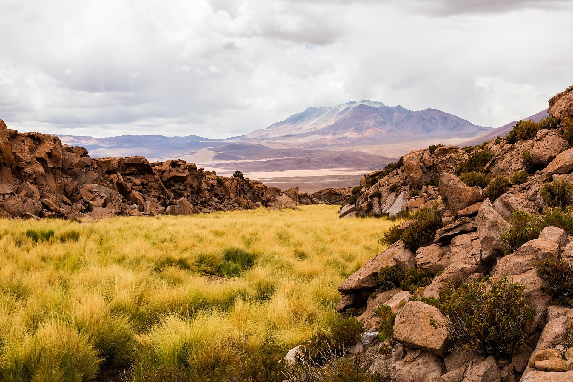
Olca rises as a broad, symmetrical stratovolcano on the Bolivia-Chile border in Nor Lípez Province. Its dark lava flows and pale sulfur-stained summit stand out against the ochre Altiplano, offering one of the most isolated high-altitude hikes in the region. Unlike the crowded peaks near Uyuni, Olca sees few visitors, delivering quiet ridgelines and unobstructed views of neighboring volcanoes such as Ollagüe and the vast salt-crusted basins to the east.

Reaching the Mountain

Most travelers start in Uyuni. A sturdy 4×4 with local driver is essential; the route follows dirt tracks west through Colcha K and then south along the international border for roughly six hours. No regular public transport exists, so independent visitors arrange transport and fuel in advance. The final approach ends at a high plain near 4,300 meters where basic campsites sit beside a small stream.

Permits and Local Support

Although Olca lies outside formal park boundaries, community permission is required. Drivers obtain this in Colcha K or at the small settlement of Chiguana. Hiring a local guide or driver is strongly advised for navigation and safety on the unmarked tracks.

Climbing and Exploring Olca

The standard route follows a broad southwest ridge. From camp the ascent gains about 1,100 meters over 4–5 hours on loose volcanic scree and occasional snow patches. The summit plateau is wide and flat, allowing easy movement between the highest point and the old crater rim. Clear days reveal the steaming fumaroles of Ollagüe across the border and the white expanse of Salar de Coipasa far to the northeast. Descent follows the same ridge; most parties return to camp the same day.

Best Time to Visit

The dry season from May through October brings stable weather and firm ground. June to August offers the clearest skies for photography and stargazing, though nighttime temperatures frequently drop below –10 °C. November to April brings occasional afternoon thunderstorms and muddy tracks that can strand vehicles.

Nearby Attractions

After Olca, many travelers continue to the active Ollagüe volcano, the colorful Laguna Colorada inside Eduardo Avaroa Reserve, or the dramatic rock formations of the Siloli Desert. These sites lie within a day’s drive and share the same high-desert ecosystem.

Visitor tips

  • Acclimatize for at least two full days in Uyuni (3,650 m) before attempting the summit to reduce altitude-sickness risk.
  • Carry at least four liters of water per person and extra fuel; no services exist beyond Colcha K.
  • Pack layers for rapid temperature swings and a reliable GPS or satellite communicator, as mobile coverage ends well before the mountain.

Frequently asked questions

How high is Olca and how difficult is the climb?+

Olcau2019s summit reaches 5,407 meters. The hike is non-technical but strenuous due to altitude, loose scree, and long approach; most fit hikers complete it in a long day from a high camp.

Do I need a guide or special permit?+

Community permission obtained through your driver is required; hiring a local driver or guide is the safest and most respectful option on these remote tracks.

What is the best season for clear weather?+

May through October offers the driest conditions; Juneu2013August provides the most stable skies and coldest nights.

Can I combine Olca with Salar de Uyuni?+

Yes. Most itineraries begin or end in Uyuni, adding one or two extra days for the western volcano circuit after visiting the salt flat.

Is there any water or shelter on the mountain?+

A small stream near the usual campsite provides water; otherwise the area is completely undevelopedu2014bring all supplies and a sturdy tent.

Share
Google Maps Apple Maps Directions

Image: Diego Delso · CC BY-SA 4.0 · via Wikimedia Commons

Keep reading

Nearby & related

All stories
P
Nor Lípez Province

Pampa Luxsar: Bolivia’s Remote Andean Mountain in Nor Lípez

A stark volcanic peak offering solitude, sweeping altiplano views, and access to the dramatic landscapes of southwest…

12 October 2026
P
Nor Lípez Province

Paruma: Hiking Bolivia’s Remote Stratovolcano in Nor Lípez

A stark, high-altitude Andean peak offering solitude, volcanic landscapes, and sweeping views over the Bolivian…

11 October 2026
I
Nor Lípez Province

Irruputuncu: Bolivia’s Remote Border Volcano in Nor Lípez

A high-altitude Andean stratovolcano offering stark altiplano views and solitude on the Bolivia-Chile frontier.

11 October 2026