Skip to content
Plan & Tour
DestinationsItinerariesTravel BlogAboutContact
0Sign inPlan a trip
Plan & TourPlan & Tour

Travel guides, destination inspiration and curated itineraries for Canada, the USA and beyond, plus a free tool to plan your own day-by-day trip.

Get travel inspiration

Explore

  • All Destinations
  • Curated Itineraries
  • Travel Blog
  • Plan a Trip

Topics

  • Hiking & Nature
  • Food & Drink
  • City Breaks
  • Budget Travel

Company

  • About Us
  • Contact
  • Privacy Policy
  • Terms of Service

© 2026 Plan & Tour. Built for travellers.

Discover the world, one trip at a time.

Mount Wrangell: Climbing Alaska’s Massive Shield Volcano
  1. Home
  2. Destinations
  3. Alaska
  4. Mount Wrangell: Climbing Alaska’s Massive Shield Volcano
Mountain

Mount Wrangell: Climbing Alaska’s Massive Shield Volcano

A practical guide to visiting North America’s largest active volcano inside Wrangell-St. Elias National Park.

AlaskaUpdated 13 August 2026

Why Mount Wrangell Stands Out

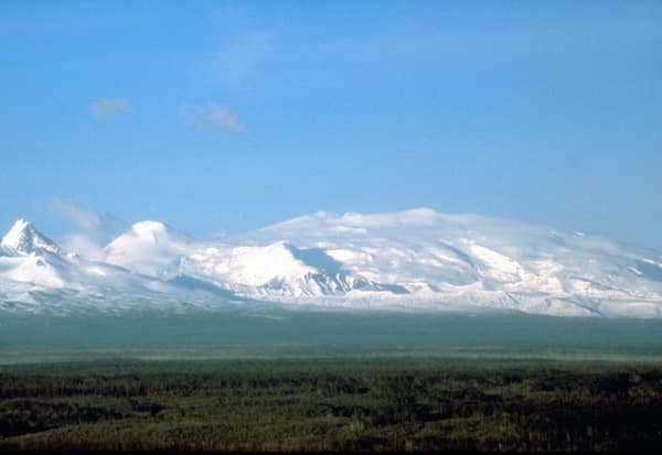
Mount Wrangell is a broad shield volcano rising to 14,163 feet in the heart of Wrangell-St. Elias National Park and Preserve. Its gentle slopes, formed by repeated lava flows, contrast with the jagged peaks that surround it. The mountain remains geothermally active, with steam vents and hot springs visible near the summit crater, offering visitors a rare chance to stand on a living volcano without technical mountaineering.

Getting There

Most travelers fly into Anchorage, then take a scheduled flight or charter to McCarthy or Nabesna. From McCarthy, a 60-mile gravel road leads toward the park’s interior; four-wheel-drive vehicles are strongly recommended. Guided air-taxi operators can land parties on the snow-covered slopes or the high plateau near the summit for day or multi-day trips. No maintained trails reach the crater, so all ascents require route-finding across glaciers and snowfields.

Best Time to Visit

June through early September offers the longest daylight and most stable weather. Snow bridges over crevasses are strongest in early summer, while late August brings clearer skies for photography. Winter ascents are possible but demand full winter camping skills and avalanche awareness. Avoid late spring when meltwater weakens snow bridges.

What to See and Do

Strong hikers can reach the crater rim in two to three days from landing zones at 8,000–10,000 feet. The broad summit plateau allows easy walking between steam vents. Photographers prize the 360-degree views of the Copper River basin, the St. Elias Range, and the vast Nabesna Glacier. Wildlife sightings often include Dall sheep on lower ridges and grizzly bears near the tree line. For a less strenuous option, scenic flights circle the volcano and land at the Kuskulana Glacier terminus.

Nearby Attractions

Combine a Wrangell trip with the historic Kennecott Mines National Historic Landmark, only 20 minutes from McCarthy by shuttle. The Root Glacier offers guided ice hiking, while the Nabesna Road provides remote access to the northern side of the range and excellent car camping at several primitive sites.

Visitor tips

  • Carry a satellite communicator; cell coverage is nonexistent beyond McCarthy.
  • Book air taxis weeks aheadu2014summer weather windows fill quickly and cancellations are common.
  • Pack layers for rapid temperature swings; expect freezing conditions above 10,000 feet even in July.

Frequently asked questions

Do I need a permit to climb Mount Wrangell?+

No special climbing permit is required, but all visitors must follow Wrangell-St. Elias National Park regulations, including bear-safe food storage.

How difficult is the hike to the summit?+

The route is non-technical but physically demanding because of distance, altitude, and glacier travel. Most parties use skis or snowshoes and hire a guide for crevasse safety.

Can I drive close to the mountain?+

The nearest road ends roughly 30 miles from the base. From there, access is by foot, ski, or small aircraft only.

Is Mount Wrangell currently erupting?+

The volcano is classified as potentially active, but no major eruption has occurred since the 19th century. Minor steam emissions are normal and monitored by the Alaska Volcano Observatory.

What wildlife might I encounter?+

Dall sheep, mountain goats, grizzly bears, and wolves are regularly seen on the lower slopes. Proper bear-aware camping practices are essential.

Share
Google Maps Apple Maps Directions

Image: Public domain · via Wikimedia Commons

Keep reading

Nearby & related

All stories
Agattu Island: A Remote Wilderness Haven in Alaska’s Aleutians
Aleutians West Census Area

Agattu Island: A Remote Wilderness Haven in Alaska’s Aleutians

Experience the untouched tundra, seabird colonies, and stark beauty of Agattu, one of the western Aleutian Islands’ most…

13 August 2026
Etolin Island: Remote Wilderness in Alaska’s Tongass National Forest
Alaska

Etolin Island: Remote Wilderness in Alaska’s Tongass National Forest

Explore the dense rainforests, black bear habitat, and quiet waterways of this little-visited island near Wrangell.

13 August 2026
St. Matthew Island: A Remote Bering Sea Wilderness in Alaska
Alaska

St. Matthew Island: A Remote Bering Sea Wilderness in Alaska

Experience the stark beauty, massive seabird colonies, and untouched tundra of this isolated island in Alaska’s Bering…

13 August 2026