Skip to content
Plan & Tour
DestinationsItinerariesTravel BlogAboutContact
0Sign inPlan a trip
Plan & TourPlan & Tour

Travel guides, destination inspiration and curated itineraries for Canada, the USA and beyond, plus a free tool to plan your own day-by-day trip.

Get travel inspiration

Explore

  • All Destinations
  • Curated Itineraries
  • Travel Blog
  • Plan a Trip

Topics

  • Hiking & Nature
  • Food & Drink
  • City Breaks
  • Budget Travel

Company

  • About Us
  • Contact
  • Privacy Policy
  • Terms of Service

© 2026 Plan & Tour. Built for travellers.

Discover the world, one trip at a time.

Mount Shishaldin: Alaska’s Perfect Volcanic Cone in the Aleutians
  1. Home
  2. Destinations
  3. Alaska
  4. Mount Shishaldin: Alaska’s Perfect Volcanic Cone in the Aleutians
Mountain

Mount Shishaldin: Alaska’s Perfect Volcanic Cone in the Aleutians

Explore the remote, symmetrical stratovolcano on Unimak Island that ranks among North America's most active peaks.

AlaskaUpdated 13 August 2026

Why Mount Shishaldin Stands Out

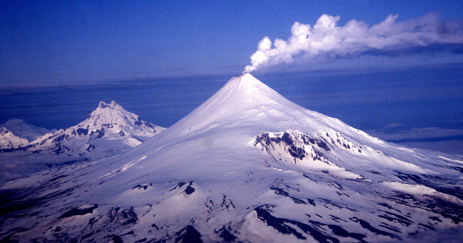
Mount Shishaldin rises as a textbook stratovolcano with an almost perfectly symmetrical cone that draws comparisons to Japan’s Mount Fuji. At 9,373 feet, it dominates Unimak Island in the eastern Aleutian chain and remains one of the most frequently active volcanoes in the United States. Its steep slopes and persistent steam plume create dramatic scenery visible from miles away, while the surrounding tundra and coastal lowlands support dense populations of brown bears, caribou, and seabirds.

Getting There

Reaching Mount Shishaldin requires planning because the mountain lies within the Alaska Maritime National Wildlife Refuge on remote Unimak Island. Most visitors fly from Anchorage to Cold Bay, then charter a boat or small aircraft to the island’s northern or western shores. From landing beaches, hikers follow unmaintained trails or river valleys toward the volcano’s base. Fixed-wing flights can drop climbers higher on the mountain when weather permits, but all access depends on the Aleutian weather window.

Best Time to Visit

June through early September offers the longest daylight and relatively milder temperatures for travel and climbing. Snow lingers on upper slopes year-round, yet summer reduces avalanche risk and improves visibility for photography and route-finding. Winter visits are possible only for highly experienced teams equipped for extreme cold, high winds, and prolonged darkness.

What to See and Do

Strong hikers and mountaineers tackle the standard west-ridge route, which gains nearly 9,000 feet from sea level and demands crampons, ice axes, and glacier travel skills. Photographers favor viewpoints along the northern coastline where the cone rises directly from the sea. Wildlife viewing along the approach trails often yields close encounters with bears and nesting seabirds on nearby cliffs. Those who stay lower can explore the volcanic ash plains and hot-spring areas that dot the lower flanks.

Nearby Attractions

Other notable volcanoes on Unimak include Mount Westdahl and Mount Fisher, both visible from Shishaldin approaches. The Izembek National Wildlife Refuge on the mainland offers world-class waterfowl viewing just a short boat ride away. Further west along the Aleutian chain lie additional volcanic islands and historic World War II sites on Adak and Amchitka.

Visitor tips

  • Carry satellite communication and file a detailed itinerary with local authorities; cell coverage is nonexistent.
  • Pack for sudden weather changes and carry extra food and fuel because resupply is impossible once on the island.
  • Hire a local Cold Bay guide or outfitter familiar with Unimak landing beaches and bear safety protocols.

Frequently asked questions

Do I need a permit to climb Mount Shishaldin?+

Visitors must obtain a permit from the Alaska Maritime National Wildlife Refuge before landing on Unimak Island.

How difficult is the climb?+

The ascent involves long glacier travel and steep snow slopes; it is considered a serious mountaineering objective requiring technical skills and crevasse rescue knowledge.

Can beginners visit the mountain?+

Novices should limit activities to coastal hiking or boat-based viewing rather than attempting the summit.

What wildlife might I encounter?+

Brown bears, caribou, and numerous seabird colonies are common; proper food storage and bear-aware travel are essential.

Is there cell service or rescue availability near the volcano?+

There is no cell coverage; emergency response relies on satellite devices and can take days in poor weather.

Share
Google Maps Apple Maps Directions

Image: Allan Shimada, NOAA NMFS/OST/AMD. · Public domain · via Wikimedia Commons

Keep reading

Nearby & related

All stories
Sagavanirktok River: Rafting Alaska’s Remote Arctic Frontier
North Slope Borough

Sagavanirktok River: Rafting Alaska’s Remote Arctic Frontier

Experience the wild, roadless beauty of one of Alaska’s northernmost rivers on the North Slope.

17 August 2026
Buckland River: Remote Wilderness Fishing in Alaska’s Arctic Frontier
Northwest Arctic Borough

Buckland River: Remote Wilderness Fishing in Alaska’s Arctic Frontier

Paddle, fish, and explore the untouched Buckland River deep in northwest Alaska’s Arctic landscape.

17 August 2026
Gulkana River: Alaska’s Premier Salmon Fishing and Wilderness Float
Southeast Fairbanks Census Area

Gulkana River: Alaska’s Premier Salmon Fishing and Wilderness Float

The Gulkana River delivers remote Alaska wilderness, world-class salmon runs, and scenic multi-day floats in the Copper…

17 August 2026