Skip to content
Plan & Tour
DestinationsItinerariesTravel BlogAboutContact
0Sign inPlan a trip
Plan & TourPlan & Tour

Travel guides, destination inspiration and curated itineraries for Canada, the USA and beyond, plus a free tool to plan your own day-by-day trip.

Get travel inspiration

Explore

  • All Destinations
  • Curated Itineraries
  • Travel Blog
  • Plan a Trip

Topics

  • Hiking & Nature
  • Food & Drink
  • City Breaks
  • Budget Travel

Company

  • About Us
  • Contact
  • Privacy Policy
  • Terms of Service

© 2026 Plan & Tour. Built for travellers.

Discover the world, one trip at a time.

Mount Recheshnoi: Hiking Alaska’s Remote Aleutian Volcano on Umnak Island
  1. Home
  2. Destinations
  3. Alaska
  4. Mount Recheshnoi: Hiking Alaska’s Remote Aleutian Volcano on Umnak Island
Mountain

Mount Recheshnoi: Hiking Alaska’s Remote Aleutian Volcano on Umnak Island

A guide to exploring the rugged volcanic terrain, wildlife, and isolation of Mount Recheshnoi in Alaska's Aleutian chain.

AlaskaUpdated 14 August 2026

Why Mount Recheshnoi Stands Out

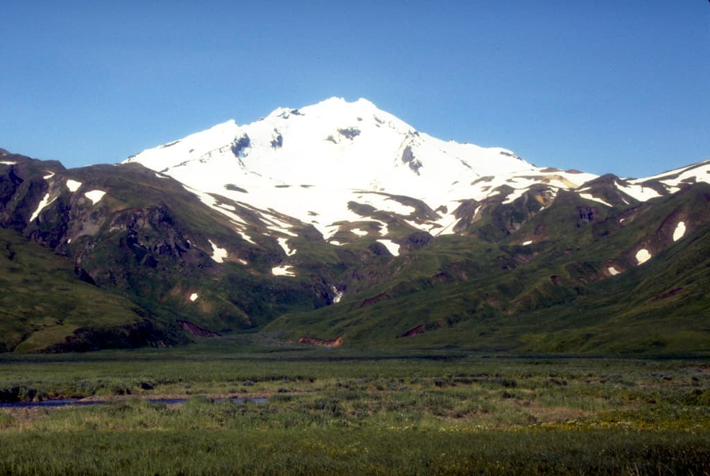
Mount Recheshnoi rises as a classic stratovolcano on Umnak Island, offering one of the most isolated backcountry experiences in the Aleutian Islands. Its steep slopes, fumaroles, and alpine tundra create a stark, windswept landscape shaped by frequent volcanic activity and harsh maritime weather. Visitors come for the sense of true wilderness rather than established trails or facilities.

Getting There

Access begins with a flight to Dutch Harbor on Unalaska Island, followed by a charter boat or small-plane hop across the narrow strait to Umnak. From the village of Nikolski, travelers continue by ATV, skiff, or foot across tundra and lava fields. No roads connect the mountain to any settlement, so all logistics depend on local operators and weather windows.

Best Time to Visit

July and August bring the longest daylight and relatively calmer seas, making overland travel and wildlife viewing most feasible. Snow lingers into June on higher slopes, while September storms can close boat access for days. Winter visits are possible only for experienced mountaineers equipped for extreme cold and high winds.

What to See and Do

Strong hikers can ascend the northwest ridge for panoramic views of the caldera and surrounding bays. Lower slopes offer easy wandering through colorful lichen and wildflower meadows where caribou, foxes, and nesting seabirds are common. Photographers favor the contrast between dark volcanic rock and bright ocean. Sea kayaking along the island’s south coast reveals sea otters and occasional whales, while hot-spring seeps near the base provide natural soaking spots.

Nearby Places Worth Exploring

Okmok Caldera on the northern end of Umnak offers another dramatic volcanic landscape reachable by boat or extended hike. The historic village of Nikolski provides insight into Unangax̂ culture and a small museum. Further afield, the volcanic peaks of Unalaska Island and the marine-rich waters around Dutch Harbor round out a longer Aleutian itinerary.

Visitor tips

  • Carry all food, fuel, and shelter; no services exist beyond Nikolski.
  • Book boat or air charters weeks ahead and maintain flexible dates for weather delays.
  • File a detailed itinerary with local contacts and carry a satellite communicator.

Frequently asked questions

Do I need a guide to climb Mount Recheshnoi?+

A local guide or experienced partner is strongly recommended because routes are unmarked and weather changes rapidly.

Is there cell service near the mountain?+

No reliable cell coverage exists on Umnak; satellite messengers or radios are essential for safety.

What wildlife might I encounter?+

Caribou, Arctic foxes, sea otters, and nesting seabirds are common; maintain distance and secure food from bears.

How long does the hike to the summit take?+

A round-trip from the lower slopes typically requires two to three full days for fit hikers with good weather.

Can I camp anywhere on the mountain?+

Camping is allowed on public land but choose sites away from active fumaroles and potential lahar paths.

Share
Google Maps Apple Maps Directions

Image: Public domain · via Wikimedia Commons

Keep reading

Nearby & related

All stories
Mount Dutton: Hiking Alaska’s Remote Volcanic Peak
Alaska

Mount Dutton: Hiking Alaska’s Remote Volcanic Peak

A guide to reaching and exploring the rugged summit of Mount Dutton on the Alaska Peninsula.

14 August 2026
Mount Chamberlin: A Remote Wilderness Peak in Alaska’s Arctic Refuge
Alaska

Mount Chamberlin: A Remote Wilderness Peak in Alaska’s Arctic Refuge

Discover hiking, wildlife, and solitude on this high Brooks Range summit deep inside the Arctic National Wildlife…

14 August 2026
Devils Thumb: Alaska’s Remote Granite Icon in the Stikine Icecap
Alaska

Devils Thumb: Alaska’s Remote Granite Icon in the Stikine Icecap

This striking 9,077-foot spire draws experienced climbers to its sheer walls amid Alaska’s vast icefields.

14 August 2026