Skip to content
Plan & Tour
DestinationsItinerariesTravel BlogAboutContact
0Sign inPlan a trip
Plan & TourPlan & Tour

Travel guides, destination inspiration and curated itineraries for Canada, the USA and beyond, plus a free tool to plan your own day-by-day trip.

Get travel inspiration

Explore

  • All Destinations
  • Curated Itineraries
  • Travel Blog
  • Plan a Trip

Topics

  • Hiking & Nature
  • Food & Drink
  • City Breaks
  • Budget Travel

Company

  • About Us
  • Contact
  • Privacy Policy
  • Terms of Service

© 2026 Plan & Tour. Built for travellers.

Discover the world, one trip at a time.

Mount Fee: Hiking the Remote Volcanic Peak Near Whistler
  1. Home
  2. Destinations
  3. British Columbia
  4. Mount Fee: Hiking the Remote Volcanic Peak Near Whistler
Mountain

Mount Fee: Hiking the Remote Volcanic Peak Near Whistler

Explore the rugged trails, volcanic landscapes, and sweeping coastal mountain views at this lesser-known British Columbia summit.

British ColumbiaUpdated 31 July 2026

Why Visit Mount Fee

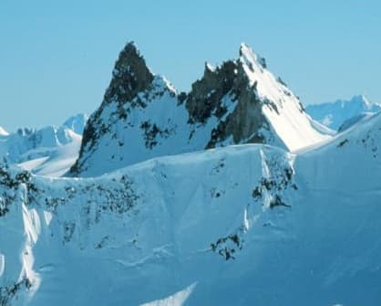
Mount Fee rises as a striking stratovolcano in the Garibaldi Volcanic Belt, offering hikers and backcountry enthusiasts a quieter alternative to the crowds at nearby Whistler. Its steep slopes and exposed ridges deliver panoramic views of the Sea to Sky Corridor, including glimpses of Mount Garibaldi and the Tantalus Range. The mountain’s volcanic origins add geological interest, with lava flows and cinder cones visible along routes.

Getting There

Access begins from Highway 99 between Squamish and Pemberton. Travelers turn onto forestry service roads that lead toward the mountain’s base; high-clearance vehicles are recommended because surfaces can be rough and seasonal. From trailheads, routes ascend through old-growth forest before breaking onto alpine meadows and rocky terrain. Navigation aids such as topographic maps or GPS are essential, as signage is minimal.

Best Time to Visit

July through September provides the most reliable window for hiking, when snow has melted from upper slopes and daylight hours are long. Early summer may still hold lingering snowfields, while fall brings cooler temperatures and fewer insects. Winter visits require avalanche awareness and specialized equipment, limiting most visitors to experienced ski tourers.

Activities and What to See

Day hikes reach lower viewpoints, while multi-day trips allow summit attempts and exploration of side ridges. Photographers prize the contrast between dark volcanic rock and distant glacier-capped peaks. Wildlife sightings may include mountain goats and marmots. Nearby, the Cheakamus River offers paddling opportunities, and the village of Whistler supplies resupply and lodging.

Nearby Attractions

  • Garibaldi Provincial Park for established trails and lakes
  • Whistler’s network of alpine lifts and bike parks
  • Squamish for rock climbing at the Stawamus Chief

Combining a visit to Mount Fee with these destinations creates a balanced Sea to Sky itinerary without requiring long drives between sites.

Visitor tips

  • Carry sufficient water and layers, as weather changes rapidly above treeline.
  • Inform someone of your route and expected return time before entering remote forestry roads.
  • Respect active logging areas by checking current road status with local forestry offices.

Frequently asked questions

How difficult is the hike to Mount Feeu2019s summit?+

The route involves steep, unmaintained trails with route-finding challenges and some scrambling near the top; it suits experienced hikers comfortable with off-trail travel.

Is Mount Fee suitable for beginners?+

No, the lack of maintained paths and remote setting make it better for those with prior backcountry experience.

Can I camp near Mount Fee?+

Dispersed camping is possible in suitable clearings below the alpine zone; practice Leave No Trace principles and avoid fragile meadows.

What wildlife might I encounter?+

Mountain goats, marmots, and occasional black bears inhabit the area; carry bear spray and store food properly.

Are there any facilities on the mountain?+

There are no huts, toilets, or services; visitors must be fully self-sufficient with all supplies and emergency gear.

Share
Google Maps Apple Maps Directions

Image: Michael Coyle (talk · contribs) · CC BY-SA 3.0 · via Wikimedia Commons

Keep reading

Nearby & related

All stories
Vedder River: Salmon Fishing, Paddling and Riverside Trails in British Columbia
British Columbia

Vedder River: Salmon Fishing, Paddling and Riverside Trails in British Columbia

A clear, productive river in the Fraser Valley offering consistent chinook and coho runs, easy paddling and quiet hiking…

1 August 2026
E
British Columbia

Englishman River: Waterfalls, Forests and Salmon Runs on Vancouver Island

Hike to dramatic waterfalls, swim in clear pools, and watch salmon spawn along this Vancouver Island river.

1 August 2026
B
British Columbia

Bella Coola River: Wilderness Fishing and Grizzly Viewing in British Columbia’s Great Bear Rainforest

This remote river in the Bella Coola Valley offers world-class steelhead and salmon fishing, abundant wildlife, and…

1 August 2026


