Skip to content
Plan & Tour
DestinationsItinerariesTravel BlogAboutContact
0Sign inPlan a trip
Plan & TourPlan & Tour

Travel guides, destination inspiration and curated itineraries for Canada, the USA and beyond, plus a free tool to plan your own day-by-day trip.

Get travel inspiration

Explore

  • All Destinations
  • Curated Itineraries
  • Travel Blog
  • Plan a Trip

Topics

  • Hiking & Nature
  • Food & Drink
  • City Breaks
  • Budget Travel

Company

  • About Us
  • Contact
  • Privacy Policy
  • Terms of Service

© 2026 Plan & Tour. Built for travellers.

Discover the world, one trip at a time.

Garibaldi Volcanic Belt: Hiking British Columbia’s Dramatic Volcanic Wilderness
  1. Home
  2. Destinations
  3. British Columbia
  4. Garibaldi Volcanic Belt: Hiking British Columbia’s Dramatic Volcanic Wilderness
Mountain

Garibaldi Volcanic Belt: Hiking British Columbia’s Dramatic Volcanic Wilderness

Explore ancient lava fields, alpine lakes, and rugged peaks in this Coast Mountains volcanic zone.

British ColumbiaUpdated 31 July 2026

Why the Garibaldi Volcanic Belt Stands Out

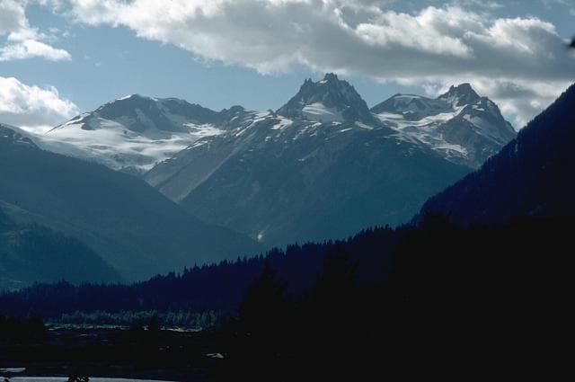
The Garibaldi Volcanic Belt forms a striking chain of Quaternary volcanoes stretching through southwestern British Columbia. Its landscapes include steep stratovolcanoes, extensive lava flows, and glacially carved valleys that create a unique backdrop for hiking and backcountry travel. The belt’s geology produces dramatic contrasts between dark volcanic rock and bright turquoise lakes fed by glacial melt.

Top Places to Visit and Activities

Garibaldi Provincial Park anchors much of the accessible terrain, with trails leading to Garibaldi Lake and the Black Tusk. Hikers can traverse ridges offering views of Mount Garibaldi and surrounding icefields. Further north, areas around Meager Creek feature hot springs emerging from volcanic heat, while the Mount Cayley region offers remote routes through ash deposits and forested slopes. Activities center on multi-day backpacking, scrambling on volcanic rock, and photography of the distinctive cone shapes and lava benches.

Day Hikes and Longer Treks

  • Routes to Garibaldi Lake cross old lava flows and deliver close views of the volcanic cone.
  • The trail network around the Black Tusk allows ridge walks with panoramas of the entire belt.
  • Backcountry routes near Mount Meager connect hot-spring basins with alpine meadows.

Getting There and Getting Around

Most visitors reach the southern sections via Highway 99 north from Vancouver, turning onto park access roads near Squamish or Whistler. Northern segments require travel along logging roads from Pemberton or Lillooet. A high-clearance vehicle helps on gravel approaches. Once inside the parks, travel is on foot; no public transit serves trailheads directly.

Best Time to Visit

Late July through early September offers the most reliable snow-free trails and stable weather for high-elevation travel. Shoulder seasons in June and October can work for lower routes but bring variable snow and shorter days. Winter visits demand avalanche awareness and ski or snowshoe access.

Nearby Destinations

Whistler provides lodging and services south of the belt, while the Sea-to-Sky corridor offers additional coastal hikes. To the east, the Duffey Lake area connects to further Coast Mountain wilderness. Travelers often combine a Garibaldi visit with stops in Squamish for rock climbing or river rafting.

Visitor tips

  • Carry layers and rain gear, as weather can change rapidly even in summer at elevation.
  • File a trip plan and check current trail conditions with BC Parks before heading out, especially for remote northern sections.
  • Practice Leave No Trace principles and pack out all waste to protect fragile volcanic soils and alpine vegetation.

Frequently asked questions

Do I need a permit to hike in the Garibaldi Volcanic Belt?+

Most day hikes in Garibaldi Provincial Park do not require permits, but overnight backcountry camping requires advance reservations through BC Parks during peak season.

Are there bears in the area and how should I prepare?+

Black and grizzly bears inhabit the region. Carry bear spray, make noise on trails, and store food properly in provided caches or hard-sided containers.

What makes the Garibaldi Volcanic Belt different from other BC mountains?+

The belt features recent volcanic features such as lava flows, cinder cones, and geothermal activity that are absent from the surrounding non-volcanic Coast Mountains.

Can I visit hot springs without a guide?+

Some springs near Meager Creek are reachable by marked trails, but others require route-finding skills and awareness of private land or active geothermal hazards.

Is the Garibaldi Volcanic Belt suitable for beginners?+

Lower trails around Garibaldi Lake suit fit beginners, but many routes involve steep, rocky terrain and require prior hiking experience and good fitness.

Share
Google Maps Apple Maps Directions

Image: Lee Siebert · Public domain · via Wikimedia Commons

Keep reading

Nearby & related

All stories
Vedder River: Salmon Fishing, Paddling and Riverside Trails in British Columbia
British Columbia

Vedder River: Salmon Fishing, Paddling and Riverside Trails in British Columbia

A clear, productive river in the Fraser Valley offering consistent chinook and coho runs, easy paddling and quiet hiking…

1 August 2026
E
British Columbia

Englishman River: Waterfalls, Forests and Salmon Runs on Vancouver Island

Hike to dramatic waterfalls, swim in clear pools, and watch salmon spawn along this Vancouver Island river.

1 August 2026
B
British Columbia

Bella Coola River: Wilderness Fishing and Grizzly Viewing in British Columbia’s Great Bear Rainforest

This remote river in the Bella Coola Valley offers world-class steelhead and salmon fishing, abundant wildlife, and…

1 August 2026


