Skip to content
Plan & Tour
DestinationsItinerariesTravel BlogAboutContact
0Sign inPlan a trip
Plan & TourPlan & Tour

Travel guides, destination inspiration and curated itineraries for Canada, the USA and beyond, plus a free tool to plan your own day-by-day trip.

Get travel inspiration

Explore

  • All Destinations
  • Curated Itineraries
  • Travel Blog
  • Plan a Trip

Topics

  • Hiking & Nature
  • Food & Drink
  • City Breaks
  • Budget Travel

Company

  • About Us
  • Contact
  • Privacy Policy
  • Terms of Service

© 2026 Plan & Tour. Built for travellers.

Discover the world, one trip at a time.

Heart Peaks: A Remote Volcanic Adventure in Northern British Columbia
  1. Home
  2. Destinations
  3. British Columbia
  4. Heart Peaks: A Remote Volcanic Adventure in Northern British Columbia
Mountain

Heart Peaks: A Remote Volcanic Adventure in Northern British Columbia

Venture into the wild Tahltan Highland to explore one of Canada’s largest volcanic complexes.

British ColumbiaUpdated 31 July 2026

Why Heart Peaks Draws Serious Adventurers

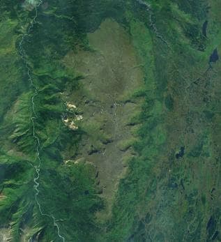
Heart Peaks rises as a vast shield volcano complex in the remote Tahltan Highland of northern British Columbia. Its broad, gently sloping form stretches roughly 35 kilometres across, shaped by ancient lava flows and dotted with cinder cones and obsidian outcrops. The mountain offers no developed trails or facilities, rewarding only those prepared for true wilderness travel with sweeping tundra views, clear alpine lakes, and the chance to witness the raw geology of the Northern Cordilleran Volcanic Province.

How to Reach Heart Peaks

Access begins with a flight to Dease Lake or Telegraph Creek. From there, travellers arrange fixed-wing charter flights or helicopter drops to high-elevation lakes or ridges near the volcano’s flanks. A few rough mining tracks extend partway into the region, but most visitors rely on air support followed by multi-day backpacking routes. Self-sufficient navigation with topographic maps and GPS is essential, as cell service is nonexistent.

Best Time to Visit

July and August provide the only reliable window when snow has melted from lower slopes and daytime temperatures allow comfortable travel. Earlier in the season, deep snow lingers on the plateau; by September, early storms can strand parties. Plan for long daylight hours but pack for sudden temperature drops and frequent rain.

Activities and What to See

Experienced hikers traverse the broad summit plateau, examining volcanic features such as pressure ridges and lava tubes. Wildlife sightings may include grizzly bears, woodland caribou, and golden eagles. Photographers find dramatic foregrounds of twisted volcanic rock against distant ice-capped peaks. Those with mountaineering skills can ascend secondary cones for panoramic views over the surrounding Stikine Plateau. All activities require bear-aware camping practices and full self-sufficiency.

Nearby Destinations

  • Mount Edziza Provincial Park lies to the southwest, offering similar volcanic terrain with established hiking routes.
  • The Spatsizi Plateau Wilderness Provincial Park provides river paddling and big-game viewing opportunities.
  • Telegraph Creek serves as the nearest supply point with historic buildings and access to the Stikine River.

Heart Peaks rewards careful planning with solitude and geological drama found nowhere else in southern Canada.

Visitor tips

  • Carry a satellite communicator and file a detailed trip plan with a trusted contact before departure.
  • Pack extra fuel, food, and repair supplies; resupply points are days away by air or foot.
  • Travel in groups of at least three and practice strict bear-country protocols at all camps.

Frequently asked questions

Do I need a guide to visit Heart Peaks?+

No formal guiding service operates at Heart Peaks. Only experienced backcountry travellers with strong navigation skills should attempt the area independently.

Are there any established trails or huts?+

There are no maintained trails, shelters, or campsites. Visitors must be fully self-sufficient with tents, water treatment, and navigation tools.

What permits are required?+

No entry permit is needed for the mountain itself, but travellers should check current access rules with the Tahltan Central Government and BC Parks for any overlapping protected areas.

How difficult is the hiking?+

Routes involve route-finding across tussock tundra, loose volcanic rubble, and stream crossings with no trail markers. Expect demanding travel even on gentle slopes.

Can I fly in and out the same day?+

Day trips are impractical due to the mountainu2019s size and the time required to explore meaningful sections. Multi-day itineraries are standard.

Share
Google Maps Apple Maps Directions

Image: NASA · Public domain · via Wikimedia Commons

Keep reading

Nearby & related

All stories
Vedder River: Salmon Fishing, Paddling and Riverside Trails in British Columbia
British Columbia

Vedder River: Salmon Fishing, Paddling and Riverside Trails in British Columbia

A clear, productive river in the Fraser Valley offering consistent chinook and coho runs, easy paddling and quiet hiking…

1 August 2026
E
British Columbia

Englishman River: Waterfalls, Forests and Salmon Runs on Vancouver Island

Hike to dramatic waterfalls, swim in clear pools, and watch salmon spawn along this Vancouver Island river.

1 August 2026
B
British Columbia

Bella Coola River: Wilderness Fishing and Grizzly Viewing in British Columbia’s Great Bear Rainforest

This remote river in the Bella Coola Valley offers world-class steelhead and salmon fishing, abundant wildlife, and…

1 August 2026


