Skip to content
Plan & Tour
DestinationsItinerariesTravel BlogAboutContact
0Sign inPlan a trip
Plan & TourPlan & Tour

Travel guides, destination inspiration and curated itineraries for Canada, the USA and beyond, plus a free tool to plan your own day-by-day trip.

Get travel inspiration

Explore

  • All Destinations
  • Curated Itineraries
  • Travel Blog
  • Plan a Trip

Topics

  • Hiking & Nature
  • Food & Drink
  • City Breaks
  • Budget Travel

Company

  • About Us
  • Contact
  • Privacy Policy
  • Terms of Service

© 2026 Plan & Tour. Built for travellers.

Discover the world, one trip at a time.

Cinder Cone: Hiking British Columbia’s Volcanic Landmark
  1. Home
  2. Destinations
  3. British Columbia
  4. Cinder Cone: Hiking British Columbia’s Volcanic Landmark
Mountain

Cinder Cone: Hiking British Columbia’s Volcanic Landmark

Climb the striking cinder cone in Garibaldi Provincial Park for sweeping views of the Coast Mountains and surrounding volcanic landscape.

British ColumbiaUpdated 31 July 2026

Overview of Cinder Cone

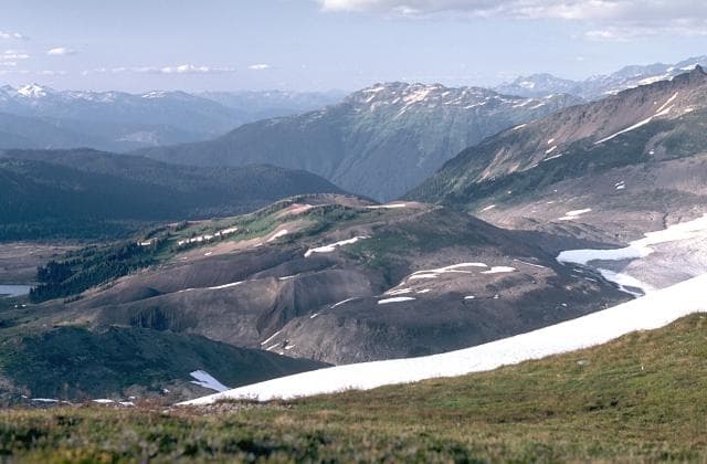
Cinder Cone rises as a classic volcanic landform within Garibaldi Provincial Park in southwestern British Columbia. Formed by explosive eruptions thousands of years ago, the steep-sided peak consists of loose dark scoria and ash that creates a distinctive reddish-brown profile against the surrounding granite peaks. The summit rewards hikers with 360-degree vistas that include the glaciated slopes of Mount Garibaldi, the Cheakamus River valley, and distant peaks of the Sea-to-Sky corridor.

Getting There

Access begins from the Squamish area via Highway 99, turning east onto the Cheakamus Lake Forest Service Road. A short drive leads to the trailhead parking area near the park boundary. From there, the maintained path follows old logging roads before climbing steadily through subalpine forest and open meadows. The route is well-marked but involves steady elevation gain on loose volcanic material near the final ascent.

Best Time to Visit

July through September offers the most reliable conditions, when snow has melted from the upper slopes and wildflowers bloom in the meadows. Early summer may still hold patches of snow on north-facing sections, while fall brings cooler temperatures and fewer visitors. Winter travel requires avalanche awareness and specialized gear, as the cone lies in an active snow zone.

What to See and Do

The primary activity is the out-and-back hike to the crater rim and true summit. Along the way, hikers pass through old-growth cedar-hemlock forest before emerging onto rocky slopes dotted with hardy alpine plants. At the top, the shallow crater depression and panoramic sightlines make for excellent photography. Many visitors combine the trip with a stop at nearby Cheakamus Lake for a refreshing swim after the descent.

Nearby Attractions

Garibaldi Provincial Park offers additional options including the popular Black Tusk trail and the scenic Panorama Ridge viewpoint. The town of Whistler lies roughly an hour north, providing lodging, dining, and gondola rides for those extending their stay. Southward, the Sea-to-Sky Highway leads to Squamish for rock climbing at the Stawamus Chief or a visit to the Britannia Mine Museum.

Practical Considerations

  • Carry plenty of water, as sources are limited above the treeline.
  • Stay on established trails to protect fragile alpine vegetation.
  • Check current park conditions and obtain any required day-use permits before departure.

Visitor tips

  • Start early in the morning to avoid afternoon clouds that often obscure summit views.
  • Wear sturdy hiking boots with good ankle support, as the upper slopes consist of loose cinder that shifts underfoot.
  • Bring layers and rain gear; mountain weather can change rapidly even on clear days.

Frequently asked questions

How long does the hike to the summit take?+

Most fit hikers complete the round-trip in five to seven hours, depending on pace and stops for photos.

Is Cinder Cone suitable for beginners?+

The trail involves significant elevation gain and loose terrain near the top, so it is best suited for those with some hiking experience and good fitness.

Are there facilities at the trailhead?+

Basic parking and an outhouse are available, but no potable water or visitor center exists at the starting point.

Can I camp near Cinder Cone?+

Backcountry camping is permitted in designated sites within Garibaldi Provincial Park; reservations are recommended during peak season.

What wildlife might I encounter?+

Black bears, marmots, and mountain goats are occasionally seen; store food properly and make noise on the trail.

Share
Google Maps Apple Maps Directions

Image: Lee Siebert · Public domain · via Wikimedia Commons

Keep reading

Nearby & related

All stories
Vedder River: Salmon Fishing, Paddling and Riverside Trails in British Columbia
British Columbia

Vedder River: Salmon Fishing, Paddling and Riverside Trails in British Columbia

A clear, productive river in the Fraser Valley offering consistent chinook and coho runs, easy paddling and quiet hiking…

1 August 2026
E
British Columbia

Englishman River: Waterfalls, Forests and Salmon Runs on Vancouver Island

Hike to dramatic waterfalls, swim in clear pools, and watch salmon spawn along this Vancouver Island river.

1 August 2026
B
British Columbia

Bella Coola River: Wilderness Fishing and Grizzly Viewing in British Columbia’s Great Bear Rainforest

This remote river in the Bella Coola Valley offers world-class steelhead and salmon fishing, abundant wildlife, and…

1 August 2026