Skip to content
Plan & Tour
DestinationsItinerariesTravel BlogAboutContact
0Sign inPlan a trip
Plan & TourPlan & Tour

Travel guides, destination inspiration and curated itineraries for Canada, the USA and beyond, plus a free tool to plan your own day-by-day trip.

Get travel inspiration

Explore

  • All Destinations
  • Curated Itineraries
  • Travel Blog
  • Plan a Trip

Topics

  • Hiking & Nature
  • Food & Drink
  • City Breaks
  • Budget Travel

Company

  • About Us
  • Contact
  • Privacy Policy
  • Terms of Service

© 2026 Plan & Tour. Built for travellers.

Discover the world, one trip at a time.

Chuginadak Island: Remote Volcanic Wilderness in Alaska’s Aleutians
  1. Home
  2. Destinations
  3. Aleutians West Census Area
  4. Chuginadak Island: Remote Volcanic Wilderness in Alaska’s Aleutians
Island

Chuginadak Island: Remote Volcanic Wilderness in Alaska’s Aleutians

Discover the dramatic volcanoes, seabird colonies, and untouched terrain of this uninhabited island in the Islands of Four Mountains.

Aleutians West Census AreaUpdated 14 August 2026

Why Chuginadak Island Stands Out

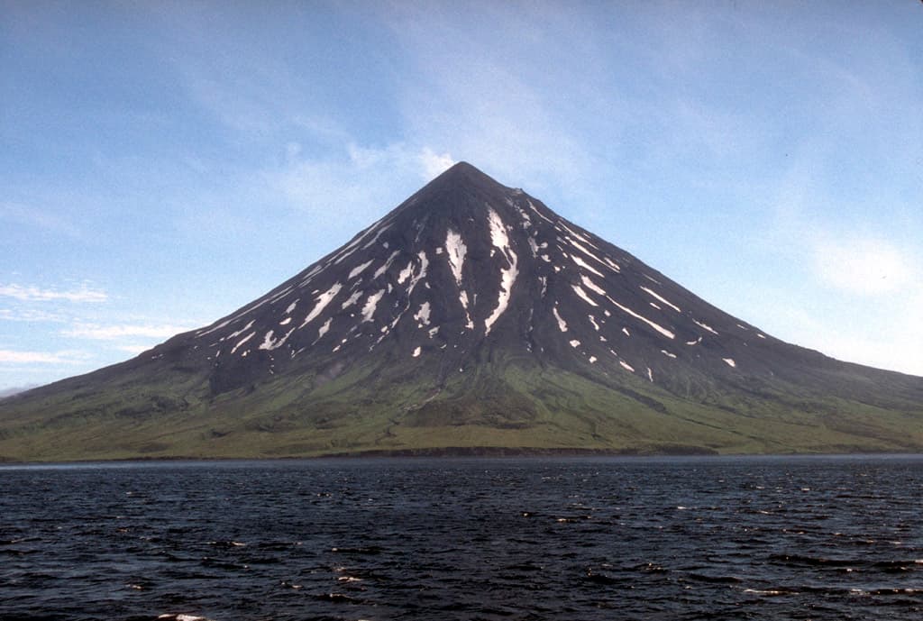
Chuginadak Island rises from the stormy North Pacific as part of the remote Islands of Four Mountains chain in the Aleutian archipelago. Its centerpiece is Mount Cleveland, a symmetrical stratovolcano that frequently steams and occasionally erupts, creating a stark contrast between black lava flows and green tundra. The island remains uninhabited, preserving a raw landscape shaped by frequent seismic activity and fierce marine weather.

Getting There

Access begins with a commercial flight to Unalaska/Dutch Harbor. From there, travelers arrange charter boats or small aircraft for the final leg across open water. Sea conditions can change rapidly, so flexible itineraries are essential. Most visitors arrive via multi-day boat expeditions that also explore neighboring islands such as Carlisle and Herbert.

What to See and Do

Hiking across the island reveals fumaroles, cinder fields, and tide pools teeming with sea stars and anemones. Seabird colonies on the cliffs include puffins, kittiwakes, and murres; binoculars help spot Steller sea lions hauled out on rocky shores. Kayakers can circumnavigate sheltered bays on calm days, while photographers capture the volcano’s plume against endless ocean horizons. No trails or facilities exist, so navigation relies on maps and GPS.

Best Time to Visit

July through early September offers the mildest weather and longest daylight for safe landings and extended hikes. Winter brings prolonged darkness and hurricane-force winds that make travel impractical. Even in summer, pack layers for sudden fog, rain, and temperature drops.

Nearby Attractions

Chuginadak sits within the Alaska Maritime National Wildlife Refuge, allowing boat-based exploration of neighboring volcanic islands and the rich marine ecosystem of the Bering Sea. Many charters continue to Unimak Island or the western Aleutians for extended wildlife viewing.

Visitor tips

  • Pack all food, water, and shelter; no services exist on the island.
  • Carry a satellite communicator and file a float plan with your charter operator.
  • Stay well clear of active fumaroles and avoid approaching wildlife to prevent disturbance.

Frequently asked questions

Do I need a permit to visit Chuginadak Island?+

No special permit is required for day visits, but travelers must follow U.S. Fish and Wildlife Service regulations within the Alaska Maritime National Wildlife Refuge.

Is Chuginadak Island safe for hiking?+

The terrain is rugged with loose volcanic rock and sudden weather changes; only experienced backcountry hikers should attempt exploration, and always travel with a guide or group.

What wildlife might I see?+

Expect seabird colonies, sea lions, and occasionally whales in surrounding waters; brown bears are absent from the island.

How long should I plan to stay?+

Most visitors spend one to three days anchored offshore, using small boats or kayaks for shore excursions during favorable weather windows.

Can I camp on Chuginadak Island?+

Primitive camping is possible but requires complete self-sufficiency and awareness of volcanic hazards and extreme wind.

Share
Google Maps Apple Maps Directions

Image: M. L. Harbin of the University of Alaska Fairbanks in a joint program, the Alaska Volcano Observatory, with the USGS[1] · Public domain · via Wikimedia Commons

Keep reading

Nearby & related

All stories
H
Aleutians West Census Area

Hammerhead Island: Remote Wilderness in Alaska’s Aleutian Chain

Experience the raw, windswept isolation and abundant marine wildlife of this uninhabited Aleutian island.

16 August 2026
L
Aleutians West Census Area

Little Kiska Island: Remote Aleutian Wilderness and WWII History

Discover the untouched landscapes, seabird colonies, and wartime relics of this isolated island in Alaska’s Aleutian…

16 August 2026
A
Aleutians West Census Area

Aziak Island: Remote Wilderness in Alaska’s Aleutian Chain

This isolated island in the central Aleutians delivers raw volcanic landscapes, seabird colonies, and true frontier…

16 August 2026