Skip to content
Plan & Tour
DestinationsItinerariesTravel BlogAboutContact
0Sign inPlan a trip
Plan & TourPlan & Tour

Travel guides, destination inspiration and curated itineraries for Canada, the USA and beyond, plus a free tool to plan your own day-by-day trip.

Get travel inspiration

Explore

  • All Destinations
  • Curated Itineraries
  • Travel Blog
  • Plan a Trip

Topics

  • Hiking & Nature
  • Food & Drink
  • City Breaks
  • Budget Travel

Company

  • About Us
  • Contact
  • Privacy Policy
  • Terms of Service

© 2026 Plan & Tour. Built for travellers.

Discover the world, one trip at a time.

Chari River: Exploring Cameroon’s Far North Waterway
  1. Home
  2. Destinations
  3. Far North
  4. Chari River: Exploring Cameroon’s Far North Waterway
River

Chari River: Exploring Cameroon’s Far North Waterway

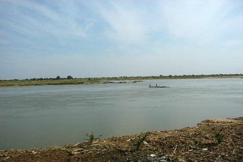
The Chari River sustains fishing communities, wildlife, and dramatic floodplains in Cameroon's remote Far North.

Far NorthUpdated 27 October 2026

Why Visit the Chari River

The Chari forms a crucial artery through the Sahelian landscape of Far North Cameroon, feeding into Lake Chad and supporting seasonal wetlands that attract migratory birds and large mammals. Visitors come for its unspoiled riverine scenery, opportunities to observe traditional fishing practices, and proximity to protected areas where hippos and antelope still thrive.

What to See and Do

Boat Excursions and Fishing Villages

Local pirogue trips reveal riverbanks lined with doum palms and acacia. Fishermen using cast nets and traps provide insight into sustainable livelihoods that have persisted for generations. Dawn departures offer the best chance to spot waterbirds and basking reptiles.

Wildlife Viewing

The river corridor serves as a dry-season refuge. Expect to see herds of kob and occasional elephants moving between water points. Crocodiles inhabit deeper pools, while the surrounding floodplains host large flocks of pelicans and storks during the wet-to-dry transition.

Community and Cultural Encounters

Visits to riverside settlements allow respectful observation of boat-building, fish smoking, and market trading. Guides from local communities explain the river’s role in seasonal migration and agriculture.

Getting There

Reach the Chari via Maroua, the regional hub. From there, 4×4 vehicles or shared taxis travel north toward the river’s Cameroonian stretches near the Chad border. Most visitors arrange transport through lodges or local operators familiar with seasonal road conditions.

Best Time to Visit

The period from November through April offers lower water levels, clearer boat navigation, and concentrated wildlife. The rainy season from June to September brings lush vegetation but can flood access tracks and increase mosquito activity.

Nearby Attractions

  • Waza National Park lies to the west and shares the same ecosystem of floodplains and acacia woodland.
  • The Mandara Mountains offer hiking and traditional villages a short distance south.
  • Logone River confluence points provide additional birding and cultural sites.

Visitor tips

  • Engage a local guide from riverside communities to ensure respectful access and accurate cultural context.
  • Carry sufficient water, sun protection, and insect repellent, as shade is limited along much of the river.
  • Travel with a reputable operator experienced in the Far North region for vehicle reliability and border-area permissions.

Frequently asked questions

Can I swim in the Chari River?+

Swimming is discouraged due to strong currents in places and the presence of crocodiles; boat-based activities are safer.

What wildlife is most likely to be seen?+

Hippos, Nile crocodiles, waterbirds, and antelope such as kob are commonly observed, especially during the dry season.

Is the area safe for independent travelers?+

Independent travel requires local knowledge of security checkpoints and road conditions; organized tours with experienced operators are strongly recommended.

Are there lodges or camps right on the river?+

Basic riverside camps and community-run guesthouses exist near key fishing settlements, though most visitors base themselves in Maroua and make day or overnight excursions.

What should I pack for a river trip?+

Light, long-sleeved clothing, sturdy footwear for riverbanks, binoculars, a reusable water bottle, and a hat are essential.

Share
Google Maps Apple Maps Directions

Image: Rebecca Musarra on en.wikipedia · CC BY-SA 2.5 · via Wikimedia Commons

Keep reading

Nearby & related

All stories
M
Far North

Massif de Mora: Hiking Cameroon’s Dramatic Far North Mountains

Discover the rugged volcanic landscapes, hiking trails, and Mandara Mountain culture at Massif de Mora near the town of…

30 October 2026
The Cultural Center and Museum of the Logone Valley: Exploring Cameroon’s Far North Heritage
Far North

The Cultural Center and Museum of the Logone Valley: Exploring Cameroon’s Far North Heritage

This museum preserves the artistic traditions, archaeological finds, and living cultures of the Logone Valley in a…

30 October 2026
Mayo Tsanaga River: Exploring Cameroon’s Remote Far North Waterway
Far North

Mayo Tsanaga River: Exploring Cameroon’s Remote Far North Waterway

This seasonal river cuts through the Mandara foothills near Maroua, offering visitors a glimpse of Sahelian landscapes,…

30 October 2026