Skip to content
Plan & Tour
DestinationsItinerariesTravel BlogAboutContact
0Sign inPlan a trip
Plan & TourPlan & Tour

Travel guides, destination inspiration and curated itineraries for Canada, the USA and beyond, plus a free tool to plan your own day-by-day trip.

Get travel inspiration

Explore

  • All Destinations
  • Curated Itineraries
  • Travel Blog
  • Plan a Trip

Topics

  • Hiking & Nature
  • Food & Drink
  • City Breaks
  • Budget Travel

Company

  • About Us
  • Contact
  • Privacy Policy
  • Terms of Service

© 2026 Plan & Tour. Built for travellers.

Discover the world, one trip at a time.

Umurata: Climbing Bolivia’s Remote Andean Peak in Sajama Province
  1. Home
  2. Destinations
  3. Sajama Province
  4. Umurata: Climbing Bolivia’s Remote Andean Peak in Sajama Province
Mountain

Umurata: Climbing Bolivia’s Remote Andean Peak in Sajama Province

A practical guide to reaching, climbing, and experiencing Umurata, one of the striking volcanic summits of Sajama National Park.

Sajama ProvinceUpdated 12 October 2026

Why Umurata Belongs on Your Bolivia Itinerary

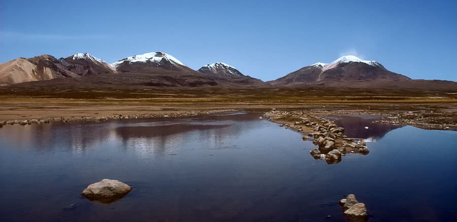
Umurata rises as a symmetrical volcanic cone on the Bolivian Altiplano, offering climbers and hikers a quieter alternative to the more famous peaks of Sajama National Park. Its position near the Chilean border delivers sweeping views across the Andean cordillera, salt flats, and the world’s highest forest of queñua trees. The mountain rewards visitors with a genuine high-altitude wilderness experience without the crowds found on neighboring Sajama or Parinacota.

Getting There

Most travelers start in La Paz. Regular buses run to the village of Sajama; the journey takes six to eight hours over paved and gravel roads. From Sajama village, 4×4 transfers or guided hikes reach the mountain’s lower slopes. No public transport serves the trailheads directly, so arranging transport with a local operator in Sajama or through La Paz agencies is standard. The nearest airport with reliable connections is El Alto International in La Paz.

Best Time to Visit

The dry season from May through October provides the most stable weather for climbing. Clear skies and minimal precipitation reduce avalanche risk and improve route-finding. Nights remain cold year-round; expect temperatures well below freezing at altitude even in the dry months. The wet season brings frequent afternoon storms and slippery volcanic scree, making ascents more technical.

What to See and Do

Most visitors attempt the standard south ridge route, a long day or overnight climb involving scree, rock bands, and a final snow or ice section depending on recent weather. Non-climbers enjoy multi-day treks around the base through vicuña habitat and past pre-Inca ruins. Nearby attractions include the geysers and hot springs of Termas de Sajama, the dramatic rock formations of the Sajama volcano itself, and the remote Laguna Blanca wetland that hosts flamingos. Combining Umurata with a circuit of the park’s other peaks creates a memorable week-long adventure.

Practical Considerations

Altitude exceeds 5,000 meters on approach routes, so a minimum of three nights in Sajama village for acclimatization is advisable. Local Aymara communities manage some campsites and can supply mules for gear. Carry plenty of water; natural sources are scarce above the queñua forest line.

Visitor tips

  • Spend at least three nights at Sajama village elevation before attempting the summit to reduce altitude sickness risk.
  • Hire a local guide or join a small-group tour from Sajama; unmarked routes and sudden weather changes make independent travel risky.
  • Pack layers for extreme temperature swings and bring enough food and fuel, as resupply options above the village are nonexistent.

Frequently asked questions

How difficult is climbing Umurata?+

The standard route is suitable for fit hikers with basic mountaineering experience; expect a long day on loose scree and possible snow near the top.

Do I need a permit to climb Umurata?+

Park entry fees apply for Sajama National Park; no additional climbing permit is required, but local community fees may be charged at trailheads.

Can beginners climb Umurata?+

Complete novices should join a guided group and ensure prior acclimatization; the mountain is not a beginner peak despite its non-technical reputation.

What wildlife might I see around Umurata?+

Vicuu00f1as graze the lower slopes, while Andean foxes and occasional condors are spotted higher up; flamingos frequent nearby wetlands.

Is Umurata accessible without a 4x4 vehicle?+

The final approach roads require high-clearance transport; most visitors arrange transfers from Sajama village rather than attempting to drive rental cars.

Share
Google Maps Apple Maps Directions

Image: Gerard Prins · CC BY-SA 3.0 · via Wikimedia Commons

Keep reading

Nearby & related

All stories
M
Sajama Province

Macizo de Pacuni: Trekking Bolivia’s Remote Andean Massif

A high-altitude massif in Sajama Province offering stark volcanic landscapes, wildlife viewing, and solitude for…

12 October 2026
A
Sajama Province

Asu Asuni: Trekking Bolivia’s Remote Andean Peak

Explore the stark volcanic landscapes and high-altitude trails of Asu Asuni in Sajama Province.

12 October 2026
M
Sajama Province

Macizo de Larancagua: Trekking Bolivia’s Remote Andean Volcanic Massif

A high-altitude wonderland of volcanic peaks, vast altiplano vistas, and wildlife-rich trails in Sajama Province.

12 October 2026