Skip to content
Plan & Tour
DestinationsItinerariesTravel BlogAboutContact
0Sign inPlan a trip
Plan & TourPlan & Tour

Travel guides, destination inspiration and curated itineraries for Canada, the USA and beyond, plus a free tool to plan your own day-by-day trip.

Get travel inspiration

Explore

  • All Destinations
  • Curated Itineraries
  • Travel Blog
  • Plan a Trip

Topics

  • Hiking & Nature
  • Food & Drink
  • City Breaks
  • Budget Travel

Company

  • About Us
  • Contact
  • Privacy Policy
  • Terms of Service

© 2026 Plan & Tour. Built for travellers.

Discover the world, one trip at a time.

M
  1. Home
  2. Destinations
  3. Sajama Province
  4. Macizo de Larancagua: Trekking Bolivia’s Remote Andean Volcanic Massif
Mountain

Macizo de Larancagua: Trekking Bolivia’s Remote Andean Volcanic Massif

A high-altitude wonderland of volcanic peaks, vast altiplano vistas, and wildlife-rich trails in Sajama Province.

Sajama ProvinceUpdated 12 October 2026

Why Visit Macizo de Larancagua

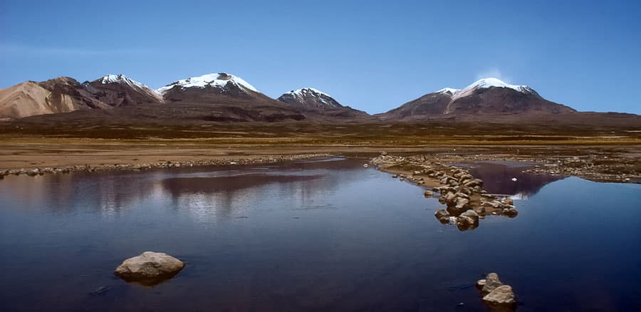
Macizo de Larancagua rises as a striking volcanic massif in Bolivia’s Sajama Province, part of the western Andean cordillera. Its rugged slopes, lava fields, and high plateaus offer visitors a raw, uncrowded alternative to more famous peaks. The area features dramatic views of neighboring Sajama volcano, one of Bolivia’s highest, and supports hardy wildlife such as vicuñas, Andean foxes, and flamingos in seasonal wetlands.

How to Get There

Most travelers reach the massif from La Paz by taking a bus or private transfer southwest to the town of Sajama, then continuing by 4×4 or local transport along dirt roads toward the base. The final approach often requires a sturdy vehicle due to rough, high-altitude tracks. Those flying into La Paz can arrange multi-day tours that include the massif as part of a Sajama National Park circuit.

Best Time to Visit

The dry season from May to October brings clearer skies and more stable trails, ideal for trekking and photography. Temperatures remain cold at night year-round, but daytime conditions are more manageable outside the wet months of December to March when roads can become impassable and lightning poses risks on exposed ridges.

What to See and Do

Hiking routes wind through ancient lava flows and offer panoramic views of the Sajama and Parinacota volcanoes. Serious trekkers can attempt the ascent of Larancagua’s main summits, while easier walks lead to highland lagoons where flamingos feed. Wildlife spotting and stargazing at over 4,000 meters are highlights. Local Aymara communities occasionally offer cultural visits that include traditional weaving demonstrations and stories of the mountain’s significance.

Nearby Attractions

The massif sits within easy reach of Sajama National Park’s hot springs and the famous Sajama tree line, the highest in the world. Further afield, the Chilean border town of Tambo Quemado provides access to Lauca National Park, while the vast Salar de Coipasa salt flat lies to the south for those extending their journey across the altiplano.

Visitor tips

  • Acclimatize for several days in La Paz or Sajama village before attempting strenuous hikes to reduce altitude sickness risk.
  • Hire a local guide or join an organized tour; trails are unmarked and weather can change rapidly at elevation.
  • Carry plenty of water, sun protection, and layered clothingu2014temperatures drop sharply after sunset even in the dry season.

Frequently asked questions

What is the elevation of Macizo de Larancagua?+

The massifu2019s highest points exceed 5,500 meters, with base areas starting around 4,200 meters above sea level.

Do I need a permit to visit Macizo de Larancagua?+

Entry to the surrounding Sajama National Park requires a small fee paid at park entrances; no separate permit is needed for the massif itself.

Is Macizo de Larancagua suitable for beginners?+

Lower trails offer moderate day hikes, but summit attempts demand prior high-altitude experience and proper acclimatization.

What wildlife might I see around the massif?+

Vicuu00f1as, vizcachas, Andean foxes, and seasonal flamingos are commonly spotted in the wetlands and grasslands.

Can I camp near Macizo de Larancagua?+

Basic campsites exist near Sajama village and along some park roads; bring all supplies as facilities are minimal.

Share
Google Maps Apple Maps Directions

Keep reading

Nearby & related

All stories
M
Sajama Province

Macizo de Pacuni: Trekking Bolivia’s Remote Andean Massif

A high-altitude massif in Sajama Province offering stark volcanic landscapes, wildlife viewing, and solitude for…

12 October 2026
A
Sajama Province

Asu Asuni: Trekking Bolivia’s Remote Andean Peak

Explore the stark volcanic landscapes and high-altitude trails of Asu Asuni in Sajama Province.

12 October 2026
Umurata: Climbing Bolivia’s Remote Andean Peak in Sajama Province
Sajama Province

Umurata: Climbing Bolivia’s Remote Andean Peak in Sajama Province

A practical guide to reaching, climbing, and experiencing Umurata, one of the striking volcanic summits of Sajama…

12 October 2026