Skip to content
Plan & Tour
DestinationsItinerariesTravel BlogAboutContact
0Sign inPlan a trip
Plan & TourPlan & Tour

Travel guides, destination inspiration and curated itineraries for Canada, the USA and beyond, plus a free tool to plan your own day-by-day trip.

Get travel inspiration

Explore

  • All Destinations
  • Curated Itineraries
  • Travel Blog
  • Plan a Trip

Topics

  • Hiking & Nature
  • Food & Drink
  • City Breaks
  • Budget Travel

Company

  • About Us
  • Contact
  • Privacy Policy
  • Terms of Service

© 2026 Plan & Tour. Built for travellers.

Discover the world, one trip at a time.

M
  1. Home
  2. Destinations
  3. Sajama Province
  4. Macizo de Pacuni: Trekking Bolivia’s Remote Andean Massif
Mountain

Macizo de Pacuni: Trekking Bolivia’s Remote Andean Massif

A high-altitude massif in Sajama Province offering stark volcanic landscapes, wildlife viewing, and solitude for experienced trekkers.

Sajama ProvinceUpdated 12 October 2026

Why Macizo de Pacuni Stands Out

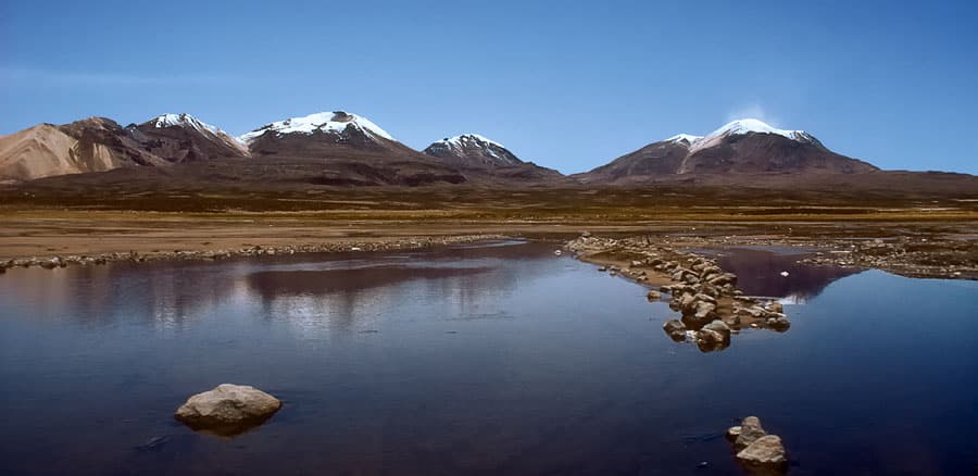
Macizo de Pacuni rises as a broad volcanic massif in Bolivia’s western Altiplano, part of the same chain that includes the country’s highest peak, Nevado Sajama. Its dark basalt slopes, scattered lava domes, and high puna grasslands create a stark, windswept setting rarely visited by tourists. The massif’s isolation preserves fragile high-Andean ecosystems where vicuñas, Andean foxes, and herds of domesticated llamas roam freely.

Getting There

Most visitors start from La Paz, traveling west on the paved highway toward the Chilean border before turning north on gravel roads that pass through the village of Sajama. From there, local transport or a 4×4 vehicle is required to reach trailheads at the base of the massif. The final approach crosses open pampas and dry riverbeds, so drivers should carry extra fuel and water. No public buses serve the immediate vicinity, making private transport or organized tours the practical options.

What to See and Do

Day hikes lead up gentle ridges to viewpoints overlooking the Sajama volcano and the distant Chilean volcanoes. Longer treks circumnavigate the massif’s northern flanks, passing seasonal wetlands that attract flamingos during the wet season. Photographers favor the golden-hour light that turns the dark rock faces red and gold. Birders can scan for Andean condors riding thermals above the peaks. Because trails are unmarked, travelers should carry a GPS or hire a local guide familiar with the terrain and water sources.

Wildlife and Culture

The surrounding puna supports large vicuña populations protected within the nearby Sajama National Park. Aymara herding communities still graze alpacas on the lower slopes; respectful travelers ask permission before crossing private land. Small hot springs near the village of Sajama provide a welcome soak after long hikes, though facilities remain basic.

Best Time to Visit

The dry season from May to October offers the clearest skies and firm ground for trekking. Afternoon winds are common year-round, so early starts are essential. The rainy months of December to March bring greener vegetation but also muddy tracks and the risk of flash floods in canyons. Nighttime temperatures can drop below freezing at any time of year, making proper layering mandatory.

Nearby Attractions

Combine a visit with Sajama village for its colonial church and traditional reed boats on nearby lakes. The massive bofedales wetlands north of the massif support additional birdlife, while the border town of Tambo Quemado offers basic supplies before crossing into Chile. Those with extra time can continue to the geothermal fields of Sol de Mañana for geysers and fumaroles.

Visitor tips

  • Acclimatize for several days at elevations above 3,500 m before attempting any hikes on the massif.
  • Carry at least three liters of water per person per day, as natural sources are scarce and unreliable.
  • Hire a local Aymara guide from Sajama village to navigate unmarked trails and respect community land boundaries.

Frequently asked questions

How high is Macizo de Pacuni?+

The massifu2019s main summits reach approximately 5,300 m, though exact elevations vary across its broad ridgelines.

Do I need a permit to visit?+

No special permit is required for the massif itself, but entry fees apply if you pass through Sajama National Park boundaries.

Is Macizo de Pacuni suitable for beginners?+

The terrain is demanding due to altitude and lack of marked trails; only experienced, well-acclimatized hikers should attempt multi-day routes.

What kind of wildlife might I see?+

Vicuu00f1as, Andean foxes, vizcachas, and occasional condors are the most common sightings on the open slopes and wetlands.

Can I camp on the massif?+

Wild camping is possible with permission from nearby herding families; bring all supplies as no facilities exist on the slopes.

Share
Google Maps Apple Maps Directions

Keep reading

Nearby & related

All stories
A
Sajama Province

Asu Asuni: Trekking Bolivia’s Remote Andean Peak

Explore the stark volcanic landscapes and high-altitude trails of Asu Asuni in Sajama Province.

12 October 2026
M
Sajama Province

Macizo de Larancagua: Trekking Bolivia’s Remote Andean Volcanic Massif

A high-altitude wonderland of volcanic peaks, vast altiplano vistas, and wildlife-rich trails in Sajama Province.

12 October 2026
Umurata: Climbing Bolivia’s Remote Andean Peak in Sajama Province
Sajama Province

Umurata: Climbing Bolivia’s Remote Andean Peak in Sajama Province

A practical guide to reaching, climbing, and experiencing Umurata, one of the striking volcanic summits of Sajama…

12 October 2026