Skip to content
Plan & Tour
DestinationsItinerariesTravel BlogAboutContact
0Sign inPlan a trip
Plan & TourPlan & Tour

Travel guides, destination inspiration and curated itineraries for Canada, the USA and beyond, plus a free tool to plan your own day-by-day trip.

Get travel inspiration

Explore

  • All Destinations
  • Curated Itineraries
  • Travel Blog
  • Plan a Trip

Topics

  • Hiking & Nature
  • Food & Drink
  • City Breaks
  • Budget Travel

Company

  • About Us
  • Contact
  • Privacy Policy
  • Terms of Service

© 2026 Plan & Tour. Built for travellers.

Discover the world, one trip at a time.

Penyal d’Honor: Hiking Mallorca’s Striking Tramuntana Summit
  1. Home
  2. Destinations
  3. Balearic Islands
  4. Penyal d’Honor: Hiking Mallorca’s Striking Tramuntana Summit
Mountain

Penyal d’Honor: Hiking Mallorca’s Striking Tramuntana Summit

A rewarding climb through olive terraces to panoramic views over the Serra de Tramuntana and the Mediterranean.

Balearic IslandsUpdated 21 September 2026

Why Penyal d’Honor Stands Out

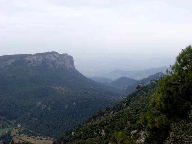
Penyal d’Honor rises sharply from the northern slopes of Mallorca’s Serra de Tramuntana, offering hikers a compact yet memorable ascent with 360-degree views that stretch from the Puig Major massif to the sea near Sóller. Its position within the UNESCO-listed Tramuntana range places it amid terraced olive groves, dry-stone walls, and dramatic limestone cliffs that define the island’s northwest interior.

The Route to the Summit

Most visitors start from the Coll de Sóller or the hamlet of Fornalutx, following well-marked paths that ascend through holm oak woodland and open scrub. The trail gains roughly 400 metres of elevation over 3–4 kilometres, passing abandoned fincas and natural springs before reaching a rocky final scramble to the summit cross. The descent follows the same path or a parallel route via the Coll des Telógrafo for variety.

What to Expect on the Trail

  • Rocky limestone underfoot that becomes slippery after rain
  • Shade from pines on the lower slopes but full sun near the top
  • Frequent sightings of black vultures and booted eagles riding thermals
  • Clear sightlines to the Formentor peninsula on crisp days

Getting There and Around

Penyal d’Honor is reached by car along the MA-10 road that threads the Tramuntana between Valldemossa and Sóller; parking is available at trailheads near the pass. Public buses run from Palma to Sóller, but onward connections to the trailhead are limited, making a rental car or taxi the most practical option. Once on the mountain, the path network connects to longer routes toward Puig de Massanella or the GR-221 dry-stone trail.

Best Time to Visit

Spring (March–May) brings wildflowers and moderate temperatures ideal for the exposed upper slopes, while autumn (September–November) offers clear skies and fewer crowds. Summer heat makes the climb strenuous, and winter can bring strong winds or occasional snow at elevation. Early morning starts help avoid afternoon cloud build-up common in the range.

Nearby Places Worth Combining

After the hike, continue to the historic village of Fornalutx with its narrow stone streets or descend to the port of Sóller for a ride on the vintage tram to the orange groves. The monastery at Valldemossa lies a short drive south along the same scenic road, allowing a full-day itinerary that balances mountain exercise with cultural stops.

Visitor tips

  • Carry at least two litres of water per person; there are no reliable refill points above the trailhead.
  • Wear sturdy hiking boots with good gripu2014the final approach involves loose scree and exposed rock.
  • Check the mountain weather forecast the evening before; sudden wind or mist can reduce visibility on the summit ridge.

Frequently asked questions

How difficult is the hike to Penyal d'Honor?+

It is a moderate outing suitable for fit walkers with some scrambling experience; the main challenge is the steep, rocky upper section rather than overall distance.

Can I reach the summit without a car?+

Buses reach Su00f3ller, but the final approach to the trailhead requires a taxi or additional walking along the road; most visitors drive.

Are dogs allowed on the trail?+

Dogs are permitted if kept on a lead, though the rocky terrain and heat make the route demanding for pets in summer.

Is there phone coverage on the mountain?+

Signal is generally reliable on the lower slopes but can drop near the summit; download an offline map before setting out.

What should I do if the weather turns bad?+

Descend immediately via the same path; the route is exposed and lightning risk is real on the bare limestone near the top.

Share
Google Maps Apple Maps Directions

Image: Antoni Sureda · CC BY-SA 3.0 · via Wikimedia Commons

Keep reading

Nearby & related

All stories
Poblat Pretalaiòtic des Figueral: Exploring Mallorca’s Hidden Bronze Age Village
Balearic Islands

Poblat Pretalaiòtic des Figueral: Exploring Mallorca’s Hidden Bronze Age Village

A quiet prehistoric settlement in northeastern Mallorca revealing early island life long before the Talayotic towers.

21 September 2026
Talaiot de Son Fred: Exploring Mallorca’s Ancient Talayotic Tower
Balearic Islands

Talaiot de Son Fred: Exploring Mallorca’s Ancient Talayotic Tower

Discover this well-preserved prehistoric monument hidden in the quiet countryside of central Mallorca.

21 September 2026
Temple Talaiòtic de Son Corró: Mallorca’s Ancient Talayotic Sanctuary
Balearic Islands

Temple Talaiòtic de Son Corró: Mallorca’s Ancient Talayotic Sanctuary

Step into the Bronze Age at this remarkably intact prehistoric temple set amid Mallorca’s rural heartland.

21 September 2026