Skip to content
Plan & Tour
DestinationsItinerariesTravel BlogAboutContact
0Sign inPlan a trip
Plan & TourPlan & Tour

Travel guides, destination inspiration and curated itineraries for Canada, the USA and beyond, plus a free tool to plan your own day-by-day trip.

Get travel inspiration

Explore

  • All Destinations
  • Curated Itineraries
  • Travel Blog
  • Plan a Trip

Topics

  • Hiking & Nature
  • Food & Drink
  • City Breaks
  • Budget Travel

Company

  • About Us
  • Contact
  • Privacy Policy
  • Terms of Service

© 2026 Plan & Tour. Built for travellers.

Discover the world, one trip at a time.

Nevado Sajama: Bolivia’s Highest Peak in the Remote Andes
  1. Home
  2. Destinations
  3. Sajama Province
  4. Nevado Sajama: Bolivia’s Highest Peak in the Remote Andes
Mountain

Nevado Sajama: Bolivia’s Highest Peak in the Remote Andes

Discover the solitary majesty of Nevado Sajama, Bolivia’s tallest mountain and a gateway to high-altitude adventure in Sajama National Park.

Sajama ProvinceUpdated 11 October 2026

Why Nevado Sajama Stands Apart

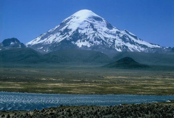
Nevado Sajama rises as Bolivia’s highest summit at 6,542 meters, an extinct stratovolcano that dominates the Altiplano landscape near the Chilean border. Its perfect cone shape and isolation create one of the most dramatic mountain profiles in the Andes, often compared to a miniature Fuji. The mountain anchors Sajama National Park, a protected area famous for its high-altitude wetlands, herds of vicuña, and the ancient Sajama Lines—pre-Inca geoglyphs etched across the surrounding plains.

How to Reach the Mountain

Most travelers start from La Paz, taking a bus southwest to Patacamaya, then transferring to a shared vehicle or private transfer that continues west across the windswept plateau to the village of Sajama. The final stretch is a rough dirt road that climbs gradually, offering ever-widening views of the snow-capped cone. Allow a full day for the journey; the road is unpaved and subject to seasonal washouts. Once in Sajama village, local guides and muleteers arrange transport to base camps or trailheads on the mountain’s lower slopes.

Activities Around the Peak

Day hikes from the village lead through queñua forests—the world’s highest woodlands—and past thermal springs that steam in the cold air. For experienced mountaineers, the standard route ascends the northwest ridge, requiring crampons and ice axes on the upper glacier. Non-climbers can circle the mountain on multi-day treks that reveal lava fields, bofedales wetlands, and panoramic views of neighboring volcanoes such as Parinacota and Pomerape. Wildlife viewing is excellent at dawn, when vicuñas graze near the road and Andean flamingos feed in shallow lagoons.

Best Time to Visit

The dry season from May to October brings stable weather and clearer skies, ideal for both trekking and summit attempts. Afternoon thunderstorms are rare during these months, though temperatures drop sharply at night. The wet season from November to April can close roads and increase avalanche risk on higher slopes, making travel unpredictable.

Exploring the Wider Sajama Region

Beyond the peak itself, the national park offers hot springs at Termas de Sajama and the chance to observe traditional Aymara communities that still herd llamas and alpacas. The Sajama Lines, visible from the air or certain ridges, represent one of South America’s lesser-known archaeological mysteries. Visitors often combine a Sajama trip with a border crossing into Chile’s Lauca National Park or a longer circuit that includes the Uyuni salt flats to the south.

Visitor tips

  • Acclimatize for several days in La Paz or at intermediate elevations before attempting any high routes around Sajama, as the village sits above 4,200 meters.
  • Hire a local guide and mule support even for non-technical hikes; the terrain is remote and weather can change quickly.
  • Carry extra layers and sun protectionu2014UV radiation is intense at altitude and temperatures swing dramatically between day and night.

Frequently asked questions

How high is Nevado Sajama and is it climbable by beginners?+

At 6,542 meters it is Boliviau2019s highest peak. The standard route involves glacier travel and requires prior mountaineering experience; beginners should consider guided trekking on the lower slopes instead.

Do I need a permit to enter Sajama National Park?+

Entrance fees are collected at the park gate near Sajama village; payment covers access to trails and basic facilities within the park boundaries.

What wildlife can I expect to see near the mountain?+

Vicuu00f1a, Andean flamingos, and vizcachas are commonly spotted in the parku2019s wetlands and rocky slopes, especially in early morning.

Is it possible to visit Nevado Sajama without climbing it?+

Yes. Many visitors enjoy day hikes through queu00f1ua forests, visits to hot springs, and viewpoints that showcase the mountain without ever stepping on snow.

How cold does it get at Sajama village?+

Nighttime temperatures frequently drop below freezing year-round; daytime highs in the dry season are usually mild but wind chill remains significant.

Share
Google Maps Apple Maps Directions

Image: Public domain · via Wikimedia Commons

Keep reading

Nearby & related

All stories
M
Sajama Province

Macizo de Pacuni: Trekking Bolivia’s Remote Andean Massif

A high-altitude massif in Sajama Province offering stark volcanic landscapes, wildlife viewing, and solitude for…

12 October 2026
A
Sajama Province

Asu Asuni: Trekking Bolivia’s Remote Andean Peak

Explore the stark volcanic landscapes and high-altitude trails of Asu Asuni in Sajama Province.

12 October 2026
M
Sajama Province

Macizo de Larancagua: Trekking Bolivia’s Remote Andean Volcanic Massif

A high-altitude wonderland of volcanic peaks, vast altiplano vistas, and wildlife-rich trails in Sajama Province.

12 October 2026