
Keep reading
Nearby & related

Squamish River: Rafting, Fishing and Wild Scenery in British Columbia
Follow the clear waters of the Squamish River through canyons, forests and gravel bars for year-round outdoor adventures…
30 June 2026
A remote wilderness summit in the Coast Mountains offering serious mountaineering amid glaciers and fjords.
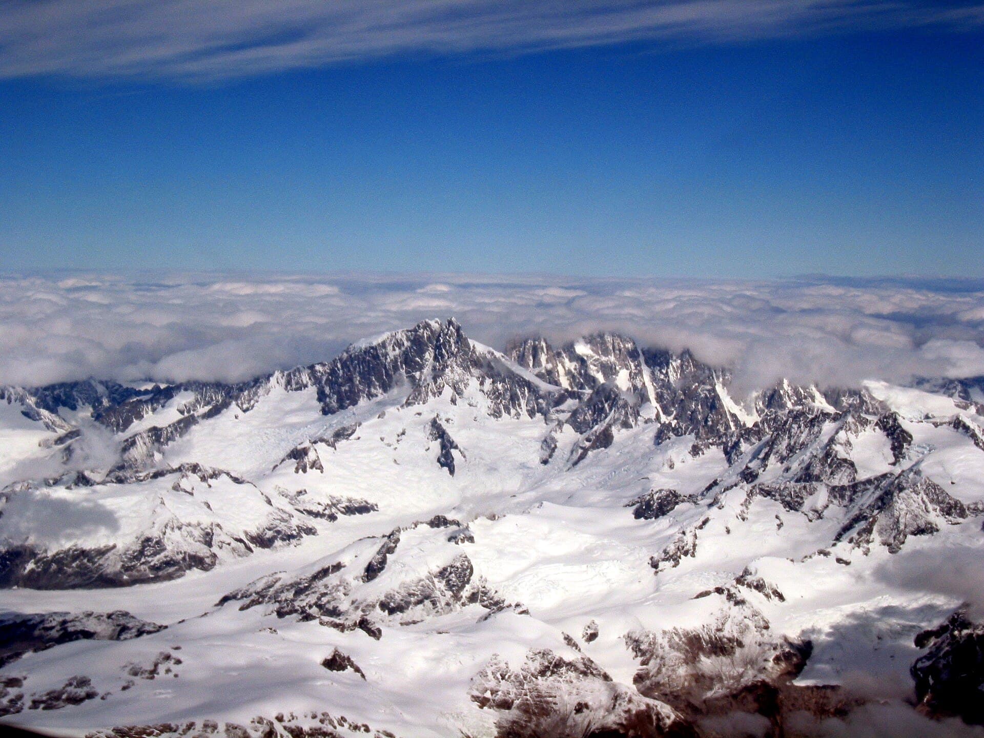
Mount Waddington rises to 4,019 metres as the highest point in British Columbia’s Coast Mountains. Its isolation, heavy glaciation, and technical routes distinguish it from more accessible peaks farther south. The mountain sits within a vast roadless region where granite spires, icefalls, and deep valleys create a true expedition environment rather than a day-hike destination.
Most visitors reach the mountain by helicopter from bases near Campbell River or Port McNeill on Vancouver Island, or from Tatlayoko Lake on the mainland. Fixed-wing flights to gravel strips at Knight Inlet or Bute Inlet are sometimes combined with boat transfers. From these points, multi-day approaches on foot or ski cross glaciers and moraines before climbers establish base camps on the Dais or Tiedemann Glacier. Self-supported parties should budget several days simply to reach the mountain.
The climbing season runs from late June through early September when snow bridges are most stable and daylight is longest. July and August offer the highest probability of clear weather windows, though afternoon thunderstorms and sudden coastal moisture can still arrive quickly. Shoulder months require greater experience with variable snow conditions and longer nights.
The standard route ascends the south face via the Dais Glacier, involving moderate snow and ice climbing with some rock sections rated up to 5.7. More committing lines exist on the north face and east ridge. Non-climbers can join ski-touring or glacier-travel courses that stay on the lower icefields. Wildlife viewing—mountain goats, grizzlies, and wolves—is possible from camp, and photographers prize the contrast between the white summit pyramid and the dark fjords visible on clear days.
After a Waddington trip, many travelers continue to the beaches and old-growth forests of northern Vancouver Island or paddle the sheltered waters of Bute Inlet. The volcanic landscapes around Bella Coola and the waterfalls of the Homathko River valley also lie within a day’s drive or flight once back on the mainland road network.
Because no facilities exist on the mountain, every party must carry full mountaineering and camping equipment plus extra food for weather delays. Permits are not required, yet filing a trip plan with friends or a local outfitter is strongly advised. Experienced local guides can arrange logistics and provide safety backup for parties lacking glacier travel skills.
Keep reading
Follow the clear waters of the Squamish River through canyons, forests and gravel bars for year-round outdoor adventures…
The peak demands intermediate to advanced mountaineering skills, glacier travel experience, and the ability to manage multi-day self-supported trips in remote terrain.
Guides are not mandatory for experienced parties, but first-time visitors to the range usually hire one for logistics, route-finding, and emergency support.
Scenic flights from Campbell River or Port McNeill offer aerial views of the peak and its surrounding icefields without setting foot on the mountain.
Expect to carry glacier travel equipment, a four-season tent, extra fuel, and at least seven days of food plus weather contingency supplies.
No permanent huts exist; all camping is on snow or moraine and visitors must be entirely self-sufficient.
A remote, reservation-controlled lake basin in British Columbia’s Rockies offering world-class day hikes amid turquoise…

Hike to one of the province’s most striking glacial lakes, framed by volcanic peaks in Garibaldi Provincial Park.
