Skip to content
Plan & Tour
DestinationsItinerariesTravel BlogAboutContact
0Sign inPlan a trip
Plan & TourPlan & Tour

Travel guides, destination inspiration and curated itineraries for Canada, the USA and beyond, plus a free tool to plan your own day-by-day trip.

Get travel inspiration

Explore

  • All Destinations
  • Curated Itineraries
  • Travel Blog
  • Plan a Trip

Topics

  • Hiking & Nature
  • Food & Drink
  • City Breaks
  • Budget Travel

Company

  • About Us
  • Contact
  • Privacy Policy
  • Terms of Service

© 2026 Plan & Tour. Built for travellers.

Discover the world, one trip at a time.

Mount Gilbert: Trekking Alaska’s Remote Aleutian Peak
  1. Home
  2. Destinations
  3. Alaska
  4. Mount Gilbert: Trekking Alaska’s Remote Aleutian Peak
Mountain

Mount Gilbert: Trekking Alaska’s Remote Aleutian Peak

A practical guide to reaching and climbing this rugged mountain on Unalaska Island.

AlaskaUpdated 15 August 2026

Introduction to Mount Gilbert

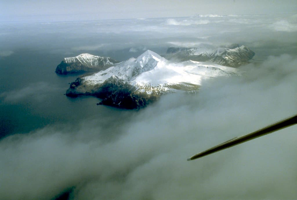
Mount Gilbert rises on the northern half of Unalaska Island in the Aleutian chain, offering hikers and climbers a true wilderness experience far from developed trail systems. The peak stands amid volcanic terrain shaped by centuries of eruptions, with steep slopes, alpine meadows, and frequent fog that define travel here.

Reaching the Mountain

Access begins with a flight to Unalaska Airport (DUT) from Anchorage. From the small town of Unalaska or adjacent Dutch Harbor, travelers arrange boat transport across Iliuliuk Bay or Captains Bay to trailheads near the mountain’s base. No roads lead directly to the peak, so every visit involves water or air transfer followed by foot travel.

Permits and Regulations

Most of the island falls under federal or state management. Check current land status with the Alaska Maritime National Wildlife Refuge or local tribal authorities before departure; some areas require advance notification even for day hikes.

Climbing and Hiking Routes

The most common approach follows drainage valleys that ascend through alder thickets before opening onto rocky ridges. Expect route-finding challenges, loose scree, and sudden weather changes. Summit attempts typically require an overnight camp due to distance and elevation gain. Experienced parties report multi-day traverses linking Mount Gilbert with neighboring peaks when conditions allow.

Wildlife and Safety

Brown bears frequent lower elevations, while sea otters and seabirds populate the surrounding waters. Carry bear spray, store food properly, and travel in groups. Hypothermia risk remains high year-round because of persistent wind and rain.

Best Time to Visit

July and August provide the longest daylight and relatively drier windows, though rain can occur any day. Snow lingers on upper slopes into early summer, and winter travel demands ice axes and avalanche awareness. Shoulder months of June and September offer fewer visitors but shorter days and more variable conditions.

Nearby Attractions

After a climb, many visitors explore the World War II remnants around Dutch Harbor, hike the easier trails of Mount Ballyhoo, or take wildlife-viewing boat trips into Unalaska Bay. The island’s Russian-era churches and active fishing harbor provide cultural contrast to the mountain’s wild interior.

Visitor tips

  • Book flights and boat charters well ahead; weather cancellations are common and seats limited.
  • Carry redundant navigation toolsu2014GPS, paper maps, and compassu2014because fog frequently obscures landmarks.
  • Pack layers for rapid temperature swings and waterproof everything; dry bags and gaiters are essential.

Frequently asked questions

How difficult is climbing Mount Gilbert?+

The route is strenuous and unmarked, requiring good fitness, route-finding skills, and preparation for multi-day travel in variable weather.

Do I need a guide to visit Mount Gilbert?+

Guides are strongly recommended for first-time visitors unfamiliar with Aleutian conditions and bear safety protocols.

What is the nearest town with services?+

Unalaska offers lodging, food, and charter services; most climbers base there before heading to the mountain.

Are there established trails to the summit?+

No maintained trails exist; hikers follow drainages and ridges using maps and GPS.

What permits are required for climbing?+

No climbing permit is needed, but land-use notifications may be required depending on the exact starting point.

Share
Google Maps Apple Maps Directions

Image: Public domain · via Wikimedia Commons

Keep reading

Nearby & related

All stories
Atna Peaks: Remote Wilderness Hiking in Alaska’s Wrangell Mountains
Alaska

Atna Peaks: Remote Wilderness Hiking in Alaska’s Wrangell Mountains

Venture into the quiet, glaciated slopes of Atna Peaks for uncrowded alpine trekking and sweeping views of Alaska’s…

15 August 2026
Mount Bear: Scaling Alaska’s Remote Wrangell Mountains Peak
Alaska

Mount Bear: Scaling Alaska’s Remote Wrangell Mountains Peak

Discover the challenges and pristine wilderness of climbing Mount Bear in Wrangell-St. Elias National Park.

15 August 2026
Mount Jarvis: Climbing Alaska’s Remote Wrangell Mountains Peak
Alaska

Mount Jarvis: Climbing Alaska’s Remote Wrangell Mountains Peak

A practical guide to reaching and experiencing the volcanic summit of Mount Jarvis deep inside Wrangell-St. Elias…

15 August 2026