Skip to content
Plan & Tour
DestinationsItinerariesTravel BlogAboutContact
0Sign inPlan a trip
Plan & TourPlan & Tour

Travel guides, destination inspiration and curated itineraries for Canada, the USA and beyond, plus a free tool to plan your own day-by-day trip.

Get travel inspiration

Explore

  • All Destinations
  • Curated Itineraries
  • Travel Blog
  • Plan a Trip

Topics

  • Hiking & Nature
  • Food & Drink
  • City Breaks
  • Budget Travel

Company

  • About Us
  • Contact
  • Privacy Policy
  • Terms of Service

© 2026 Plan & Tour. Built for travellers.

Discover the world, one trip at a time.

Mount Edgecumbe: Hiking Alaska’s Dormant Volcano Near Sitka
  1. Home
  2. Destinations
  3. Alaska
  4. Mount Edgecumbe: Hiking Alaska’s Dormant Volcano Near Sitka
Mountain

Mount Edgecumbe: Hiking Alaska’s Dormant Volcano Near Sitka

A rewarding climb to sweeping ocean and island views on Kruzof Island, just west of Sitka.

AlaskaUpdated 14 August 2026

Why Visit Mount Edgecumbe

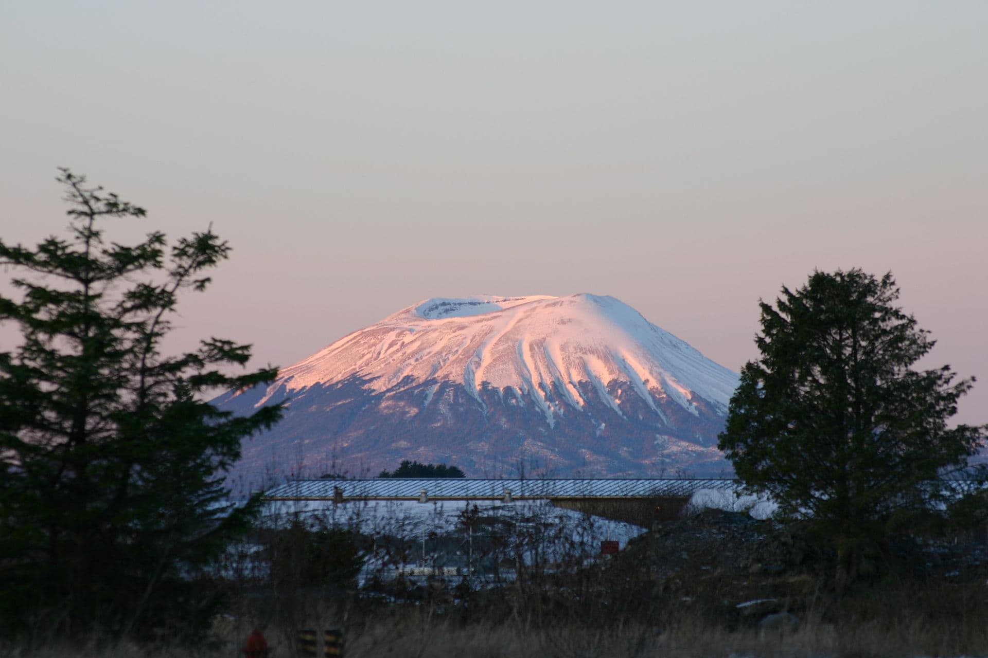
Mount Edgecumbe rises prominently from Kruzof Island across Sitka Sound, offering hikers a classic Southeast Alaska summit experience without technical climbing. The 3,200-foot volcano last erupted thousands of years ago, leaving a broad, grassy crater and open ridges that deliver unobstructed panoramas of the Pacific, Baranof Island, and distant volcanic peaks. The trail rewards steady effort with changing ecosystems from coastal rainforest to alpine meadows.

How to Get There

Access begins in Sitka. Take a water taxi or charter boat from the Sitka harbor to the Fred Sigrist Trailhead on the eastern shore of Kruzof Island, a crossing of roughly 20 minutes. Some visitors fly by floatplane for a scenic aerial approach. Once ashore, the well-marked trail climbs steadily through spruce-hemlock forest before breaking into open country. No road access exists on the island, so plan all transportation in advance from Sitka.

The Hike to the Summit

The out-and-back trail covers about seven miles with 2,500 feet of elevation gain. The lower section is forested and can be muddy; higher up, boardwalks and gravel give way to open tundra. Most hikers reach the rim in four to six hours. The broad crater floor allows easy exploration, and on clear days the 360-degree view stretches from the open ocean to the mountains of Chichagof Island. Carry plenty of water, as none is available above the treeline.

Best Time to Visit

July through early September offers the most reliable weather and longest daylight for the hike. Snow lingers on the upper slopes into June, and rain or fog can arrive any month. Winter visits require skis or snowshoes and are suited only to experienced travelers. Always check marine forecasts before crossing Sitka Sound.

Nearby Attractions

Combine the trip with time in Sitka, where Russian and Tlingit history converge at Sitka National Historical Park and the Sheldon Jackson Museum. Sea-kayak tours around nearby islands, wildlife viewing for whales and sea otters, and visits to the Alaska Raptor Center provide complementary activities on non-hiking days.

Visitor tips

  • Book water-taxi transport from Sitka the day before; schedules fill quickly in summer.
  • Wear layers and bring rain gearu2014weather changes rapidly above treeline.
  • Start early; the full round-trip often takes eight to ten hours including time on the rim.

Frequently asked questions

How difficult is the hike to Mount Edgecumbe?+

The trail is strenuous due to steady elevation gain and variable trail conditions, but it requires no technical skills. Fit hikers with good footwear complete it in a long day.

Do I need a guide or permit?+

No permit is required. Most visitors hike independently, though guided day trips are available from Sitka operators for those wanting local expertise.

What should I bring on the hike?+

Pack at least two liters of water, food, a map or GPS, rain jacket, warm layer, and sturdy boots. Trekking poles help on the descent.

Can children or beginners attempt the summit?+

The distance and elevation make it challenging for young children or first-time hikers. Strong teens and fit adults usually manage well with proper pacing.

Is there cell service on the trail?+

Service is unreliable once you leave the Sitka area. Carry a satellite communicator or inform someone of your plans.

Share
Google Maps Apple Maps Directions

Image: Duncan Mariott · Public domain · via Wikimedia Commons

Keep reading

Nearby & related

All stories
Korovin Volcano: Remote Aleutian Island Hiking in Alaska
Alaska

Korovin Volcano: Remote Aleutian Island Hiking in Alaska

Trek the dramatic slopes of this active stratovolcano on Atka Island for unmatched wilderness and volcanic scenery.

14 August 2026
Mount Isto: Alaska’s Remote Brooks Range Summit
Alaska

Mount Isto: Alaska’s Remote Brooks Range Summit

Explore the highest peak in the Brooks Range, a true wilderness adventure deep within the Arctic National Wildlife…

14 August 2026
Mount Griggs: Hiking Alaska’s Remote Volcanic Peak
Lake and Peninsula Borough

Mount Griggs: Hiking Alaska’s Remote Volcanic Peak

A guide to exploring the rugged stratovolcano and wilderness of Katmai National Park.

14 August 2026