Skip to content
Plan & Tour
DestinationsItinerariesTravel BlogAboutContact
0Sign inPlan a trip
Plan & TourPlan & Tour

Travel guides, destination inspiration and curated itineraries for Canada, the USA and beyond, plus a free tool to plan your own day-by-day trip.

Get travel inspiration

Explore

  • All Destinations
  • Curated Itineraries
  • Travel Blog
  • Plan a Trip

Topics

  • Hiking & Nature
  • Food & Drink
  • City Breaks
  • Budget Travel

Company

  • About Us
  • Contact
  • Privacy Policy
  • Terms of Service

© 2026 Plan & Tour. Built for travellers.

Discover the world, one trip at a time.

Mount Burgess: Exploring the Iconic Peak and Burgess Shale in Yoho National Park
  1. Home
  2. Destinations
  3. British Columbia
  4. Mount Burgess: Exploring the Iconic Peak and Burgess Shale in Yoho National Park
Mountain

Mount Burgess: Exploring the Iconic Peak and Burgess Shale in Yoho National Park

Discover hiking trails, fossil sites, and sweeping Rocky Mountain views at this landmark peak near Field, British Columbia.

British ColumbiaUpdated 31 July 2026

Why Visit Mount Burgess

Mount Burgess rises prominently above the Kicking Horse River valley in Yoho National Park, offering visitors a striking introduction to the Canadian Rockies. Its steep limestone cliffs and forested lower slopes frame classic alpine scenery while protecting one of the world’s most important fossil localities on its northwestern face. Travelers come for the combination of accessible day hikes, panoramic viewpoints, and the chance to stand near the Burgess Shale quarries that revealed the Cambrian explosion of life.

Getting There

Reach the mountain by driving the Trans-Canada Highway to the small community of Field, then following the Yoho Valley Road or the Emerald Lake Road. Both routes provide pullouts with clear sightlines of the peak’s distinctive profile. From Field, short walks along the Kicking Horse River trail lead to the base of the mountain, while longer routes begin at trailheads near the highway.

Best Time to Visit

July through September offers the most reliable trail access and wildflower displays. Snow lingers into July on higher routes, and early autumn brings golden larches on the lower slopes. Winter visits are possible along the highway corridor for photography, though avalanche risk limits backcountry travel.

Things to See and Do

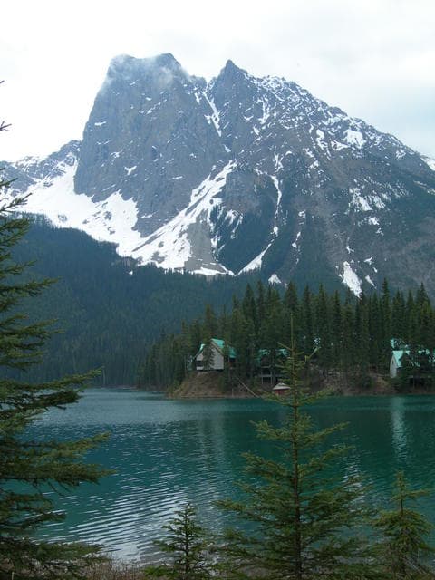
The Burgess Pass trail climbs steadily through mixed forest to open meadows with unobstructed views of Mount Burgess and the surrounding peaks. Hikers often continue toward Emerald Lake for a full-day loop. Photographers favor the shoreline of Emerald Lake at sunrise, when the mountain’s reflection appears in the turquoise water. Wildlife watchers may spot mountain goats on the cliffs and grizzly bears foraging in the valley bottoms.

Nearby Attractions

  • Emerald Lake: A short drive offers easy lakeside walking and canoeing.
  • Takakkaw Falls: One of Canada’s highest waterfalls lies farther up the Yoho Valley Road.
  • Lake O’Hara: Reservations are required for the shuttle, but the alpine meadows and peaks beyond provide a longer day or overnight extension.

Interpretive programs at the Field visitor centre explain the significance of the Burgess Shale fossils without requiring a guided hike to the restricted quarry sites.

Practical Planning

Carry bear spray and know how to use it. Trails cross active bear habitat. Pack layers for rapid weather changes common at elevation. Cell service is limited once you leave the highway corridor, so download offline maps. Respect park regulations that protect both the fossil beds and the fragile alpine vegetation.

Visitor tips

  • Start early in the day to secure parking at popular trailheads near Emerald Lake and avoid afternoon thunderstorms.
  • Check current trail conditions and bear activity reports at the Field visitor centre before heading out.
  • Bring plenty of water and snacks; there are no services once you leave the highway corridor.

Frequently asked questions

Is Mount Burgess a difficult hike?+

The lower slopes offer moderate day hikes to Burgess Pass with steady elevation gain, while the summit requires mountaineering experience and is not recommended for casual visitors.

Can I see the Burgess Shale fossils?+

The main quarry sites are protected and accessible only on guided tours arranged through the Burgess Shale Geoscience Foundation; casual visitors can learn about the fossils at park interpretive centres.

Are there facilities at Mount Burgess?+

No services exist on the mountain itself; the nearest restrooms, water, and information are in Field or at the Emerald Lake parking area.

What wildlife might I encounter?+

Grizzly bears, black bears, mountain goats, and marmots are commonly seen; always travel in groups and carry bear spray.

Is Mount Burgess suitable for families?+

The shorter interpretive trails near Emerald Lake work well for families, but longer routes to Burgess Pass require good fitness and proper footwear.

Share
Google Maps Apple Maps Directions

Image: Timon Orawski · CC BY-SA 2.5 · via Wikimedia Commons

Keep reading

Nearby & related

All stories
Vedder River: Salmon Fishing, Paddling and Riverside Trails in British Columbia
British Columbia

Vedder River: Salmon Fishing, Paddling and Riverside Trails in British Columbia

A clear, productive river in the Fraser Valley offering consistent chinook and coho runs, easy paddling and quiet hiking…

1 August 2026
E
British Columbia

Englishman River: Waterfalls, Forests and Salmon Runs on Vancouver Island

Hike to dramatic waterfalls, swim in clear pools, and watch salmon spawn along this Vancouver Island river.

1 August 2026
B
British Columbia

Bella Coola River: Wilderness Fishing and Grizzly Viewing in British Columbia’s Great Bear Rainforest

This remote river in the Bella Coola Valley offers world-class steelhead and salmon fishing, abundant wildlife, and…

1 August 2026


