Skip to content
Plan & Tour
DestinationsItinerariesTravel BlogAboutContact
0Sign inPlan a trip
Plan & TourPlan & Tour

Travel guides, destination inspiration and curated itineraries for Canada, the USA and beyond, plus a free tool to plan your own day-by-day trip.

Get travel inspiration

Explore

  • All Destinations
  • Curated Itineraries
  • Travel Blog
  • Plan a Trip

Topics

  • Hiking & Nature
  • Food & Drink
  • City Breaks
  • Budget Travel

Company

  • About Us
  • Contact
  • Privacy Policy
  • Terms of Service

© 2026 Plan & Tour. Built for travellers.

Discover the world, one trip at a time.

Montaña Tamia: Hiking Lanzarote’s Underrated Volcanic Summit
  1. Home
  2. Destinations
  3. Las Palmas
  4. Montaña Tamia: Hiking Lanzarote’s Underrated Volcanic Summit
Mountain

Montaña Tamia: Hiking Lanzarote’s Underrated Volcanic Summit

A serene hike up Montaña Tamia delivers sweeping views across Lanzarote’s volcanic landscape without the crowds.

Las PalmasUpdated 12 November 2026

Why Montaña Tamia Stands Out

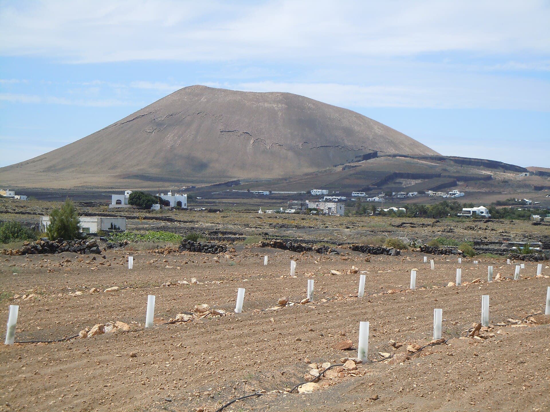
Montaña Tamia rises gently from the arid interior of Lanzarote, offering hikers a quiet alternative to busier volcanic sites. Its slopes reveal the island’s dramatic geology formed by ancient eruptions, while the summit provides unobstructed panoramas of the Famara massif, the Atlantic, and distant calderas. The trail feels remote yet accessible, making it ideal for those seeking solitude amid Lanzarote’s stark beauty.

Trail and What to Expect

The main route begins at a dirt track near the village of Guatiza and climbs steadily through dark volcanic rubble and hardy shrubs. Most visitors complete the round trip in two to three hours. The path is well-defined but rocky, with occasional steep sections near the top. At the summit, a small cairn marks the high point and serves as a perfect spot for photos or a quiet picnic. Expect strong winds on clear days and dramatic light changes as the sun moves across the island.

Flora and Fauna

Despite the harsh terrain, Montaña Tamia supports typical Lanzarote vegetation including tabaiba and cardoncillo. Birdwatchers may spot kestrels and Barbary partridges. The area remains largely untouched, preserving the raw volcanic character that defines the island.

Getting There

Drive from Arrecife along the LZ-1 highway toward Órzola, then take the LZ-201 turnoff toward Guatiza. Parking is available along the unpaved roads leading to the base. Public transport is limited, so a rental car or taxi from nearby towns is the most practical option. The mountain lies within easy reach of the César Manrique Foundation and the Cactus Garden, allowing visitors to combine cultural stops with the hike.

Best Time to Visit

Winter and spring bring milder temperatures and occasional wildflowers. Summer hikes require early starts to avoid midday heat. Always check wind forecasts, as Lanzarote’s trade winds can intensify on exposed ridges. Clear winter days offer the sharpest views across the entire island.

Nearby Attractions

  • The dramatic cliffs and beaches of Famara lie a short drive north.
  • Jameos del Agua showcases volcanic caves transformed into cultural spaces.
  • The wine region of La Geria demonstrates how vines thrive in volcanic ash just south of the mountain.

Visitor tips

  • Bring at least two liters of water per person and wear sturdy hiking shoes with good grip on loose volcanic rock.
  • Start early in the morning to avoid strong afternoon winds and enjoy cooler temperatures on the ascent.
  • Carry a light windbreaker and sun protection; the summit offers little shade and weather can change quickly.

Frequently asked questions

Is Montau00f1a Tamia suitable for beginners?+

The trail is moderate rather than technical, but the rocky surface and steady climb make it best for those with some hiking experience and good fitness.

Are dogs allowed on the trail?+

Dogs are permitted if kept on a leash, though the sharp volcanic terrain can be tough on paws.

Can I camp on Montau00f1a Tamia?+

Wild camping is not permitted; the mountain lies within protected natural areas where overnight stays are prohibited.

What should I wear for the hike?+

Layered clothing, a hat, sunglasses, and closed-toe hiking shoes are essential. The ground is uneven and dusty.

Is there any shade or water on the trail?+

There is no shade or water source along the route, so carry everything you need for the full duration of your hike.

Share
Google Maps Apple Maps Directions

Image: Patrice78500 · CC BY-SA 4.0 · via Wikimedia Commons

Keep reading

Nearby & related

All stories
Inagua Natural Reserve: Gran Canaria’s Rugged Protected Wilderness
Las Palmas

Inagua Natural Reserve: Gran Canaria’s Rugged Protected Wilderness

Discover volcanic ridges, endemic pine forests, and rare birdlife in this quiet corner of the Canary Islands.

12 November 2026
Malpaís de la Arena: Hiking Fuerteventura’s Ancient Lava Badlands
Las Palmas

Malpaís de la Arena: Hiking Fuerteventura’s Ancient Lava Badlands

Discover the stark volcanic beauty and quiet trails of this protected lava field on Fuerteventura’s northern coast.

12 November 2026
Montaña de Ajódar: Hiking Gran Canaria’s Quiet Volcanic Summit
Las Palmas

Montaña de Ajódar: Hiking Gran Canaria’s Quiet Volcanic Summit

A rugged, lesser-known peak offering sweeping island views and peaceful trails in the Canary Islands.

12 November 2026