Skip to content
Plan & Tour
DestinationsItinerariesTravel BlogAboutContact
0Sign inPlan a trip
Plan & TourPlan & Tour

Travel guides, destination inspiration and curated itineraries for Canada, the USA and beyond, plus a free tool to plan your own day-by-day trip.

Get travel inspiration

Explore

  • All Destinations
  • Curated Itineraries
  • Travel Blog
  • Plan a Trip

Topics

  • Hiking & Nature
  • Food & Drink
  • City Breaks
  • Budget Travel

Company

  • About Us
  • Contact
  • Privacy Policy
  • Terms of Service

© 2026 Plan & Tour. Built for travellers.

Discover the world, one trip at a time.

Chilkat River: Bald Eagle Capital Along the BC-Alaska Border
  1. Home
  2. Destinations
  3. British Columbia
  4. Chilkat River: Bald Eagle Capital Along the BC-Alaska Border
River

Chilkat River: Bald Eagle Capital Along the BC-Alaska Border

Float through salmon-rich waters teeming with eagles and bears in one of North America's premier wildlife corridors.

British ColumbiaUpdated 1 July 2026

Why the Chilkat River Draws Visitors Year After Year

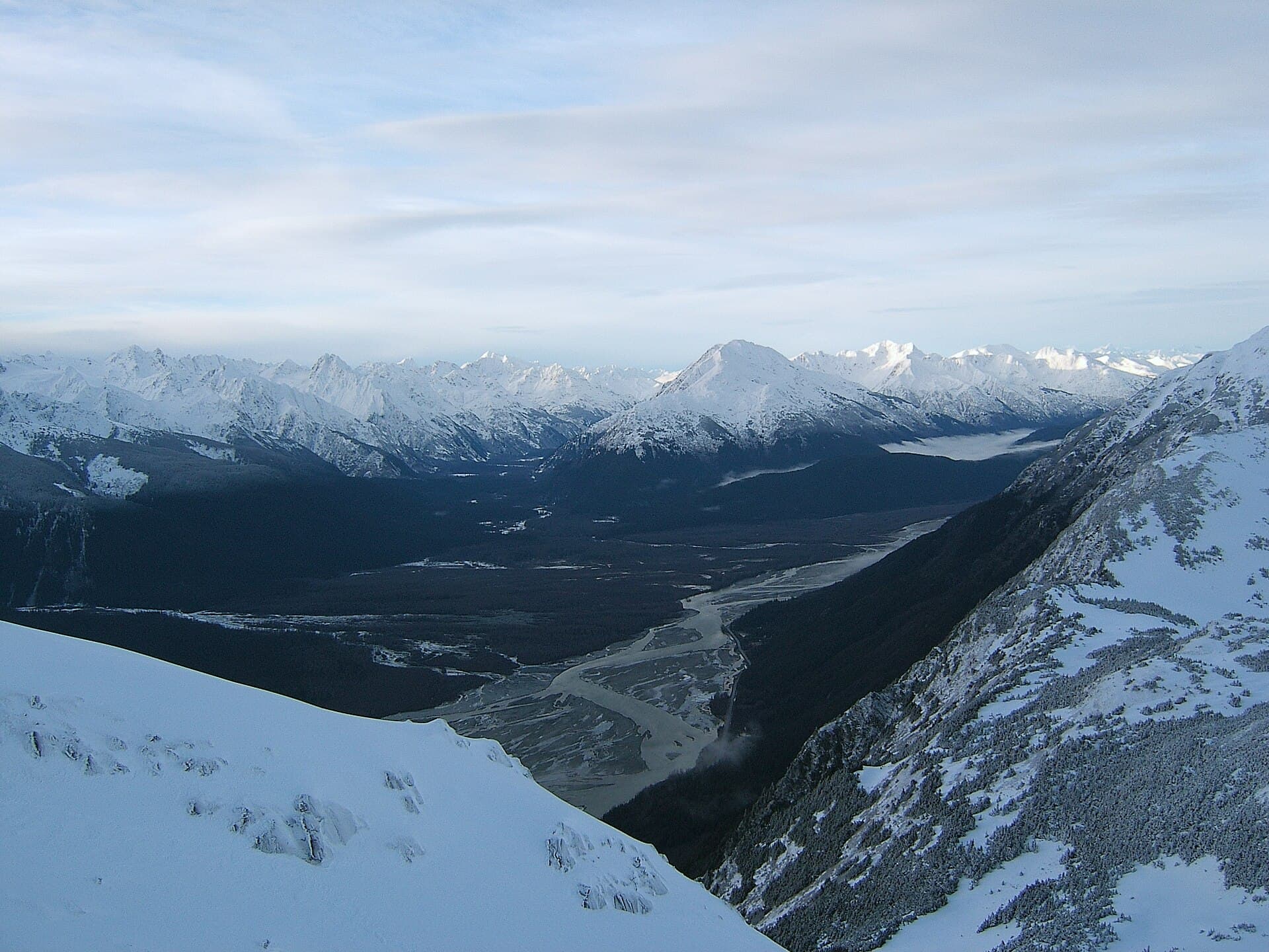
The Chilkat River begins in the high peaks of British Columbia and flows northwest into Alaska, creating a broad, braided valley that supports one of the continent’s largest concentrations of bald eagles. Its late salmon runs keep hundreds of birds fed well into winter, while the surrounding rain-shadow forests and wetlands host grizzlies, moose, and spawning salmon visible from river level.

Wildlife Viewing and River Activities

Eagle Watching

From late October through February, thousands of bald eagles gather along the Chilkat River near Klukwan. Float trips drift past cottonwood roosts where birds perch shoulder-to-shoulder. Photographers favor the low winter light that turns eagle feathers golden against snow-dusted mountains.

Summer Rafting and Kayaking

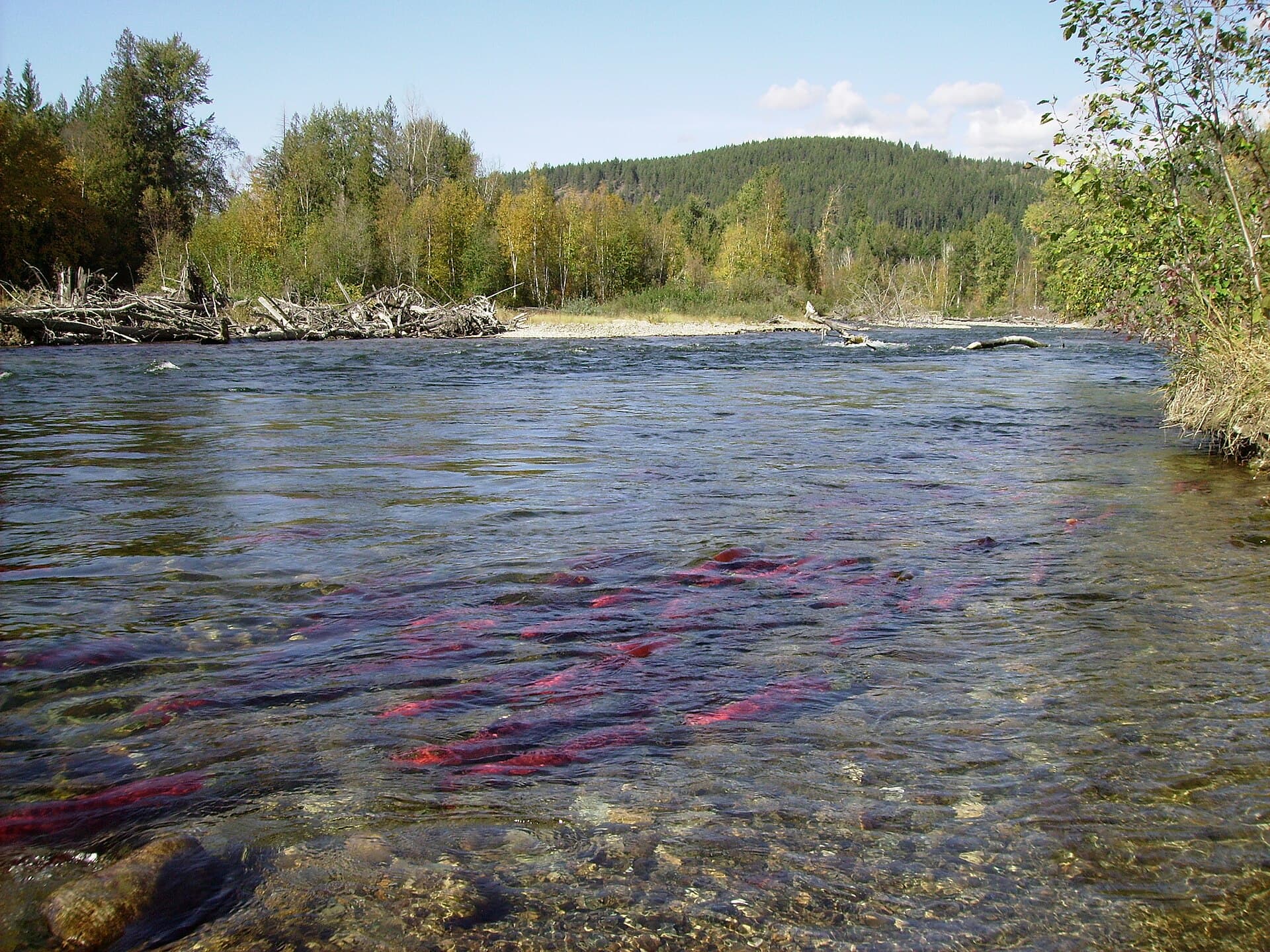
From June through August, Class I-II sections offer gentle floats suitable for families. Guides point out sockeye and chum salmon migrating upstream; anglers can target Dolly Varden and king salmon under strict catch-and-release rules in Canadian waters.

Hiking and Shoreline Exploration

Short trails from the riverbanks lead into the Chilkat River Valley, where boardwalks cross tidal flats and old-growth spruce. Look for bear tracks in the mud and spawning salmon in side channels.

Getting There

Most visitors reach the river via Haines, Alaska, then drive or boat 20–30 minutes north to Canadian sections near the border. The Haines Highway parallels the lower river for much of its length, offering pullouts for independent viewing. Travelers arriving from Whitehorse can drive south on the same highway; the border crossing is usually quick for day trips.

Best Time to Visit

October to February delivers peak eagle numbers and dramatic winter scenery. Summer months provide milder weather, longer daylight, and easier access for rafting and fishing. Shoulder seasons in September and March offer fewer crowds and transitional wildlife sightings.

Nearby Places Worth Exploring

Combine a river trip with a visit to the historic town of Haines for art galleries and ferry connections, or continue north into Canada’s Tatshenshini-Alsek Provincial Park for multi-day wilderness rafting. The nearby village of Klukwan preserves Tlingit culture and offers interpretive programs about the river’s importance to local people.

Visitor tips

  • Bring binoculars and a zoom lens; eagles often sit 50u2013100 meters away across wide channels.
  • Dress in layers and pack rain gear; weather can shift rapidly even on calm days.
  • Book float trips with operators permitted in both countries to avoid border complications mid-trip.

Frequently asked questions

Do I need a passport to visit the Chilkat River?+

Yes. The most accessible sections lie in British Columbia, so travelers must clear the Canada-U.S. border on the Haines Highway.

Are there guided tours available on the river?+

Local outfitters in Haines run half- and full-day rafting and photography tours that cross into Canadian waters with proper permits.

What kind of fish can I catch?+

The river supports runs of king, sockeye, and chum salmon plus Dolly Varden; check current regulations as rules differ between Canadian and Alaskan sections.

Is the river suitable for beginners?+

The main float sections are gentle Class I-II water, making them appropriate for novice paddlers when accompanied by a guide.

How cold does it get in winter?+

Daytime temperatures often hover around freezing with occasional dips well below zero; proper insulated clothing and wind protection are essential for eagle viewing.

Share
Google Maps Apple Maps Directions

Image: Jonathan.s.kt · CC BY-SA 3.0 · via Wikimedia Commons

Keep reading

Nearby & related

All stories
Similkameen River: A Scenic Waterway Through British Columbia’s Southern Valleys
British Columbia

Similkameen River: A Scenic Waterway Through British Columbia’s Southern Valleys

Follow the Similkameen River through dramatic canyons, fertile orchards, and quiet parks in the heart of the Similkameen…

1 July 2026
Adams River: Witnessing British Columbia’s Legendary Sockeye Salmon Migration
British Columbia

Adams River: Witnessing British Columbia’s Legendary Sockeye Salmon Migration

Discover the dramatic sockeye salmon runs, clear waters, and surrounding forests of Adams River in British Columbia’s…

1 July 2026
Dease River: Wilderness Fishing and Canoeing in Northern British Columbia
British Columbia

Dease River: Wilderness Fishing and Canoeing in Northern British Columbia

This remote northern river offers world-class angling and untouched wilderness along the Cassiar Highway corridor.

1 July 2026