Skip to content
Plan & Tour
DestinationsItinerariesTravel BlogAboutContact
0Sign inPlan a trip
Plan & TourPlan & Tour

Travel guides, destination inspiration and curated itineraries for Canada, the USA and beyond, plus a free tool to plan your own day-by-day trip.

Get travel inspiration

Explore

  • All Destinations
  • Curated Itineraries
  • Travel Blog
  • Plan a Trip

Topics

  • Hiking & Nature
  • Food & Drink
  • City Breaks
  • Budget Travel

Company

  • About Us
  • Contact
  • Privacy Policy
  • Terms of Service

© 2026 Plan & Tour. Built for travellers.

Discover the world, one trip at a time.

The Table: Hiking British Columbia’s Striking Flat-Topped Mountain
  1. Home
  2. Destinations
  3. British Columbia
  4. The Table: Hiking British Columbia’s Striking Flat-Topped Mountain
Mountain

The Table: Hiking British Columbia’s Striking Flat-Topped Mountain

A distinctive volcanic peak in Garibaldi Provincial Park offering dramatic views and rewarding scrambles near Whistler.

British ColumbiaUpdated 31 July 2026

Why The Table Stands Out

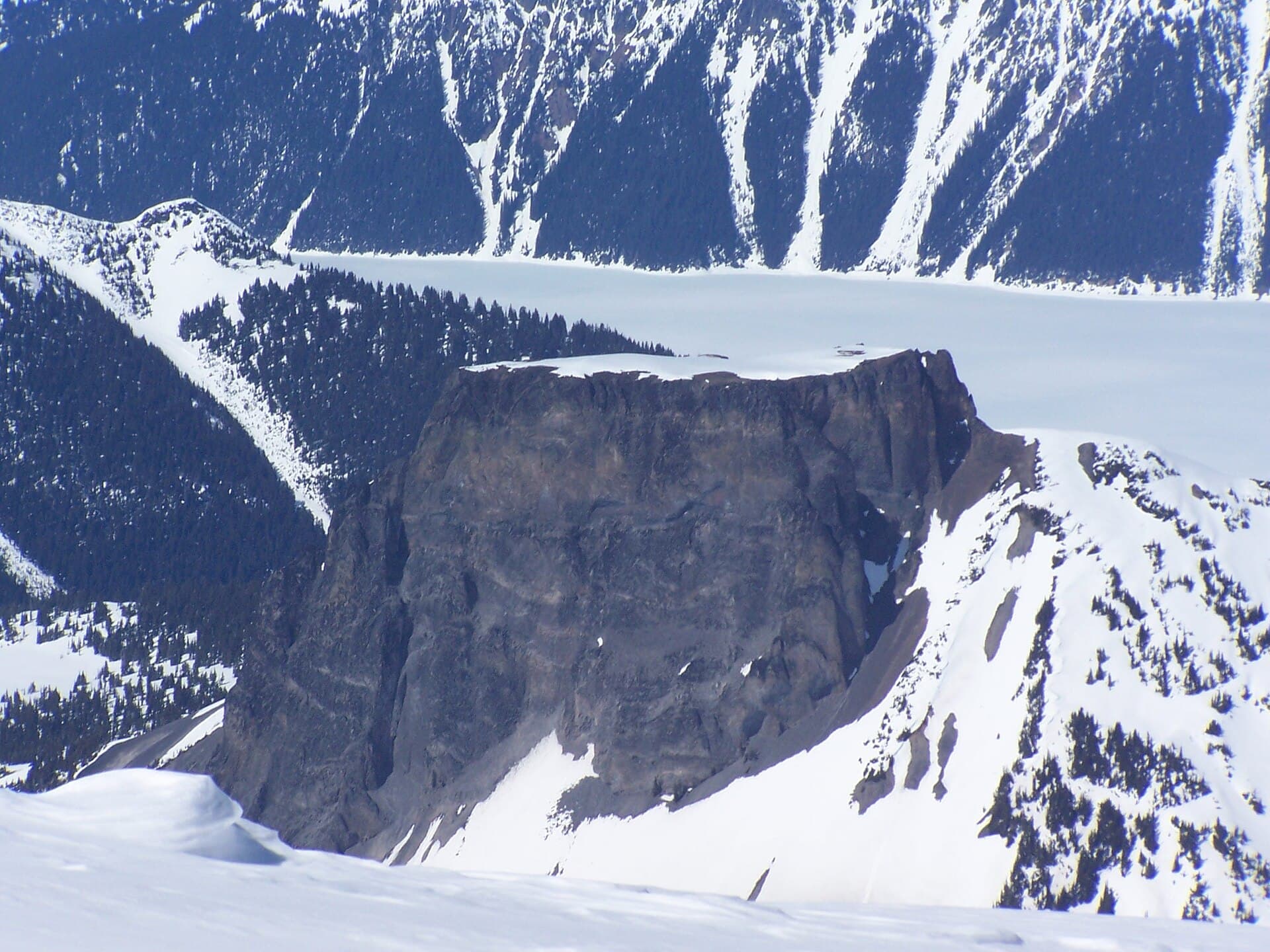
The Table rises as a broad, sheer-sided mesa amid the rugged peaks of Garibaldi Provincial Park, its flat summit the result of ancient lava flows capped by erosion-resistant rock. This geological oddity creates a natural platform with sweeping panoramas of the surrounding Coast Mountains, including neighboring Black Tusk and the turquoise waters of Garibaldi Lake below.

Getting There

Access begins from the Rubble Creek trailhead off Highway 99 between Squamish and Whistler. Hikers follow the well-marked trail past Garibaldi Lake, then branch onto the less-traveled path that climbs toward The Table’s base. The route demands solid fitness and route-finding skills once the maintained trail fades into boulder fields and steeper slopes.

What to See and Do

Most visitors aim for the summit plateau, where a short scramble leads to expansive 360-degree views. On clear days the vista stretches from the Sea-to-Sky corridor to distant icefields. Photographers favor the golden-hour light that accentuates the mountain’s vertical walls and the contrast with surrounding glaciers. Experienced scramblers can extend the outing by traversing ridgelines toward nearby peaks, while casual hikers enjoy shorter out-and-back trips that still deliver striking lake-and-peak compositions.

Best Time to Visit

Summer and early fall provide the most reliable conditions, with snow-free trails and long daylight. Wildflowers carpet lower slopes in July and August, while September brings fewer bugs and cooler temperatures ideal for longer days on rock. Winter visits require avalanche awareness and ice-axe skills, as the approach crosses steep snow slopes.

Nearby Attractions

Combine a visit with a circuit around Garibaldi Lake, where shoreline campsites offer convenient bases. The Black Tusk looms nearby for those seeking more technical terrain, and the Panorama Ridge trail provides an easier alternative with comparable lake views. Whistler village lies roughly an hour north by car, supplying lodging and supplies after multi-day park trips.

Visitor tips

  • Carry more water than you expect; the upper slopes have no reliable sources once you leave the lake basin.
  • Study the route on a detailed topographic map before leaving the trailhead, as the final approach crosses confusing boulder fields.
  • Pack layers and sun protection; the open summit offers no shade and weather can shift rapidly even on forecast-clear days.

Frequently asked questions

How difficult is the hike to The Table summit?+

The approach from Garibaldi Lake involves moderate trail hiking followed by off-trail scrambling over loose rock; it suits experienced hikers comfortable with route-finding but is not a beginner outing.

Can I camp near The Table?+

Designated campsites exist at Garibaldi Lake; no camping is permitted on The Table itself to protect the fragile alpine environment.

Is The Table visible from the highway?+

Its flat profile appears prominently from several pullouts along Highway 99 south of Whistler, especially when driving northbound past Daisy Lake.

What wildlife might I encounter?+

Marmots, pikas, and occasional mountain goats inhabit the upper slopes; keep a respectful distance and store food properly at lower campsites.

Do I need a permit to visit The Table?+

Day hikes require no permit, but overnight stays at Garibaldi Lake need advance reservations through BC Parks during peak season.

Share
Google Maps Apple Maps Directions

Image: Andre Charland · CC BY 2.0 · via Wikimedia Commons

Keep reading

Nearby & related

All stories
Vedder River: Salmon Fishing, Paddling and Riverside Trails in British Columbia
British Columbia

Vedder River: Salmon Fishing, Paddling and Riverside Trails in British Columbia

A clear, productive river in the Fraser Valley offering consistent chinook and coho runs, easy paddling and quiet hiking…

1 August 2026
E
British Columbia

Englishman River: Waterfalls, Forests and Salmon Runs on Vancouver Island

Hike to dramatic waterfalls, swim in clear pools, and watch salmon spawn along this Vancouver Island river.

1 August 2026
B
British Columbia

Bella Coola River: Wilderness Fishing and Grizzly Viewing in British Columbia’s Great Bear Rainforest

This remote river in the Bella Coola Valley offers world-class steelhead and salmon fishing, abundant wildlife, and…

1 August 2026


