Skip to content
Plan & Tour
DestinationsItinerariesTravel BlogAboutContact
0Sign inPlan a trip
Plan & TourPlan & Tour

Travel guides, destination inspiration and curated itineraries for Canada, the USA and beyond, plus a free tool to plan your own day-by-day trip.

Get travel inspiration

Explore

  • All Destinations
  • Curated Itineraries
  • Travel Blog
  • Plan a Trip

Topics

  • Hiking & Nature
  • Food & Drink
  • City Breaks
  • Budget Travel

Company

  • About Us
  • Contact
  • Privacy Policy
  • Terms of Service

© 2026 Plan & Tour. Built for travellers.

Discover the world, one trip at a time.

Spotted Lake: British Columbia’s Striking Mineral Phenomenon
  1. Home
  2. Destinations
  3. British Columbia
  4. Spotted Lake: British Columbia’s Striking Mineral Phenomenon
Lake

Spotted Lake: British Columbia’s Striking Mineral Phenomenon

A vivid natural landmark where mineral deposits create seasonal patterns visible from the roadside in the Okanagan-Similkameen.

British ColumbiaUpdated 22 June 2026

The Unique Character of Spotted Lake

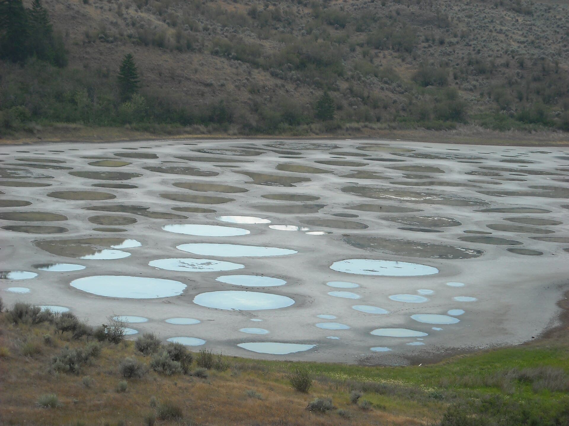
Spotted Lake sits in a dry valley near Osoyoos, its surface marked by dozens of circular mineral pools that shift in color and visibility with evaporation. High concentrations of magnesium sulfate, calcium, and trace elements produce the distinctive spots, especially prominent when summer heat reduces water levels. The site holds cultural importance to the Syilx people, who have long recognized its properties and continue to regard it with respect.

Access and Location Details

The lake lies directly beside Highway 3, roughly midway between Osooyoos and Keremeos. A dedicated roadside pullout allows clear viewing without entering the property. No trails lead onto the lake bed itself, preserving both the fragile crust and the site’s significance. Travelers heading east from Osoyoos reach the viewpoint within a 10-minute drive; those coming from Keremeos arrive after about 25 minutes on the same route.

Best Time to Visit

Late spring through early fall offers the clearest patterns as water recedes. Mid-summer typically produces the strongest contrast, though conditions vary yearly with rainfall. Winter visits show a more uniform frozen surface and reduced spotting. Sunrise and late afternoon provide the best light for photography from the pullout.

What to See and Do Nearby

Combine the stop with exploration of the surrounding desert landscape. Short drives lead to the Osoyoos Desert Centre boardwalks, where native plants and wildlife are interpreted. Wineries along the Black Sage Bench produce distinctive wines from the same arid soils. Further east, the town of Keremeos offers fruit stands and access to Cathedral Lakes Provincial Park trails. The entire corridor supports birdwatching, particularly for species adapted to dry grasslands.

Practical Considerations

  • Stay on the highway shoulder or designated pullout; the lake bed is not open to visitors.
  • Carry water and sun protection, as shade is absent at the viewpoint.
  • Allow 15–30 minutes for observation and photos before continuing along the highway.

Visitor tips

  • View the lake only from the signed roadside pullout to avoid trespassing on private and culturally sensitive land.
  • Visit between June and September for maximum visibility of the mineral circles, and plan around midday heat.
  • Combine the stop with a drive along Highway 3 to sample nearby desert ecosystems and fruit stands without backtracking.

Frequently asked questions

Can visitors walk out onto Spotted Lake?+

No. The lake bed is private property and culturally protected; all viewing occurs from the highway pullout.

When do the spots appear most clearly?+

The circular mineral patterns become most visible in summer once water evaporates, typically peaking in July and August.

Is there an entrance fee or designated parking?+

No fee applies. Parking is limited to the informal shoulder pullout beside Highway 3.

How far is Spotted Lake from Osoyoos?+

The viewpoint lies approximately 10 minutes east of Osoyoos along Highway 3.

Are there facilities such as restrooms or picnic areas?+

None exist at the pullout. Plan stops in Osoyoos or Keremeos for services.

Share
Google Maps Apple Maps Directions

Image: AndrewEnns · CC BY-SA 3.0 · via Wikimedia Commons

Keep reading

Nearby & related

All stories
Chilkat River: Bald Eagle Capital Along the BC-Alaska Border
British Columbia

Chilkat River: Bald Eagle Capital Along the BC-Alaska Border

Float through salmon-rich waters teeming with eagles and bears in one of North America’s premier wildlife corridors.

1 July 2026
Similkameen River: A Scenic Waterway Through British Columbia’s Southern Valleys
British Columbia

Similkameen River: A Scenic Waterway Through British Columbia’s Southern Valleys

Follow the Similkameen River through dramatic canyons, fertile orchards, and quiet parks in the heart of the Similkameen…

1 July 2026
Adams River: Witnessing British Columbia’s Legendary Sockeye Salmon Migration
British Columbia

Adams River: Witnessing British Columbia’s Legendary Sockeye Salmon Migration

Discover the dramatic sockeye salmon runs, clear waters, and surrounding forests of Adams River in British Columbia’s…

1 July 2026