
Skip to content
Plan & Tour
DestinationsItinerariesTravel BlogAboutContact
0Sign inPlan a trip
Plan & TourPlan & Tour

Travel guides, destination inspiration and curated itineraries for Canada, the USA and beyond, plus a free tool to plan your own day-by-day trip.

Get travel inspiration

Explore

  • All Destinations
  • Curated Itineraries
  • Travel Blog
  • Plan a Trip

Topics

  • Hiking & Nature
  • Food & Drink
  • City Breaks
  • Budget Travel

Company

  • About Us
  • Contact
  • Privacy Policy
  • Terms of Service

© 2026 Plan & Tour. Built for travellers.

Discover the world, one trip at a time.

Sa Galera: Hiking Mallorca’s Quiet Tramuntana Summit
  1. Home
  2. Destinations
  3. Balearic Islands
  4. Sa Galera: Hiking Mallorca’s Quiet Tramuntana Summit
Mountain

Sa Galera: Hiking Mallorca’s Quiet Tramuntana Summit

A compact but rewarding peak in the Serra de Tramuntana offering sweeping views without the crowds of better-known neighbours.

Balearic IslandsUpdated 21 September 2026

Why Sa Galera Stands Out

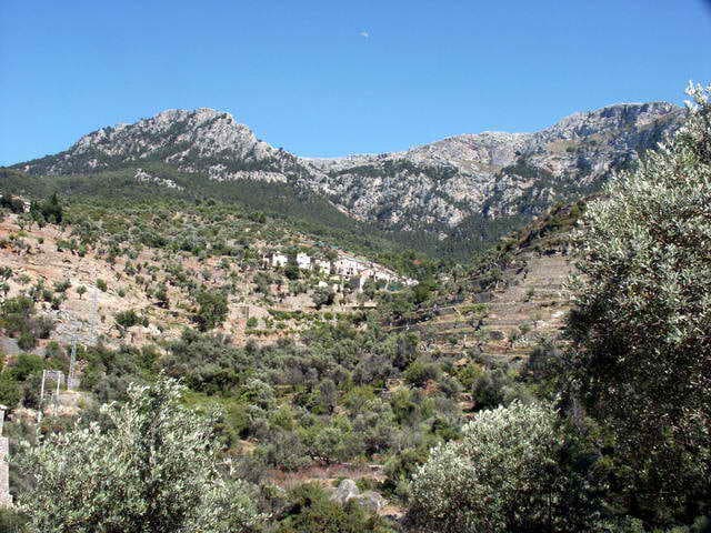
Sa Galera rises above the western slopes of Mallorca’s Serra de Tramuntana, a UNESCO World Heritage landscape of dramatic limestone ridges and terraced olive groves. Its modest height delivers 360-degree panoramas that stretch from the Puig Major massif to the Mediterranean, yet the trail remains relatively quiet compared with the island’s signature peaks.

How to Reach the Trailhead

The most practical access is from the MA-10 road between Sóller and Fornalutx. Park in the small lay-by at Coll de sa Batalla and follow the well-marked GR-221 dry-stone path that climbs gently through holm oak woodland. After roughly 45 minutes the trail forks; take the left branch signed “Sa Galera” and ascend the final rocky section to the summit cairn. Total walking time is about two hours return.

Alternative Approaches

  • From the village of Fornalutx via the old mule track that joins the GR-221 higher up.
  • Combine with the longer circuit that continues to Puig de sa Font and returns via the Torrent de Biniaraix.

Best Time to Visit

April to early June and September to October offer mild temperatures and clear visibility. Summer visits are possible but start at dawn to avoid heat and the occasional afternoon thunderstorm. Winter days can be crisp and sunny, though the upper path may be icy after rain.

What to Expect on the Summit

The final scramble reveals a flat limestone platform with a trig point and sweeping views. On clear days you can trace the entire northern coastline from Cap de Formentor to the distant Cabrera archipelago. The immediate surroundings are a mosaic of wind-sculpted rocks and endemic Balearic flora, including the rare rock violet.

Nearby Attractions Worth Combining

  • The historic village of Fornalutx with its orange groves and stone houses.
  • The Cuber reservoir, a short drive west, for easy lakeside walks.
  • The Jardins d’Alfàbia, a 17th-century estate with fountains and exotic plants just below the pass.

Visitor tips

  • Carry at least 1.5 litres of water per person; there are no springs on the route.
  • Wear approach shoes or light hiking bootsu2014the final 200 m involves loose limestone.
  • Download an offline map; mobile coverage drops once you leave the main road.

Frequently asked questions

How difficult is the hike to Sa Galera?+

It is a moderate outing suitable for fit walkers with basic route-finding skills. The total elevation gain is around 350 m on good paths, with one short rocky scramble near the top.

Can I drive all the way to the summit?+

No vehicle access exists beyond the Coll de sa Batalla parking area; the final section is a footpath only.

Is the summit suitable for children?+

Older children accustomed to mountain walking can manage the route, but the rocky top requires close supervision.

Are there facilities at the trailhead?+

There is no water or toilet at Coll de sa Batalla; the nearest services are in Su00f3ller or Fornalutx.

What should I do if the weather turns bad?+

The exposed limestone ridge offers little shelter; descend immediately via the same path if clouds build or wind increases.

Share
Google Maps Apple Maps Directions

Image: Antoni Sureda · CC BY-SA 3.0 · via Wikimedia Commons

Keep reading

Nearby & related

All stories
T
Balearic Islands

The Statue of James I of Aragon in Palma de Mallorca

Stand before the bronze monument to the king who conquered Mallorca and shaped the island’s medieval identity.

26 September 2026
M
Balearic Islands

Mirador del Centenari del Foment: Panoramic Views Over Mallorca’s Tramuntana Mountains

This secluded viewpoint delivers sweeping vistas of rugged peaks, olive terraces, and the Mediterranean from the heart…

26 September 2026
M
Balearic Islands

Mirador des Salt de la Bella Dona: Dramatic Cliffside Views in Mallorca’s Tramuntana

This secluded viewpoint reveals plunging gorges, terraced valleys, and distant sea horizons in the heart of the Serra de…

26 September 2026