Skip to content
Plan & Tour
DestinationsItinerariesTravel BlogAboutContact
0Sign inPlan a trip
Plan & TourPlan & Tour

Travel guides, destination inspiration and curated itineraries for Canada, the USA and beyond, plus a free tool to plan your own day-by-day trip.

Get travel inspiration

Explore

  • All Destinations
  • Curated Itineraries
  • Travel Blog
  • Plan a Trip

Topics

  • Hiking & Nature
  • Food & Drink
  • City Breaks
  • Budget Travel

Company

  • About Us
  • Contact
  • Privacy Policy
  • Terms of Service

© 2026 Plan & Tour. Built for travellers.

Discover the world, one trip at a time.

Reserva Natural Especial del Chinyero: Hiking Tenerife’s Youngest Volcano
  1. Home
  2. Destinations
  3. Santa Cruz de Tenerife Province
  4. Reserva Natural Especial del Chinyero: Hiking Tenerife’s Youngest Volcano
Protected area

Reserva Natural Especial del Chinyero: Hiking Tenerife’s Youngest Volcano

Explore the stark lava fields, Canary Island pine forests, and 1909 volcanic cone of this protected reserve on Tenerife’s northwest flank.

Santa Cruz de Tenerife ProvinceUpdated 12 November 2026

Why Visit Reserva Natural Especial del Chinyero

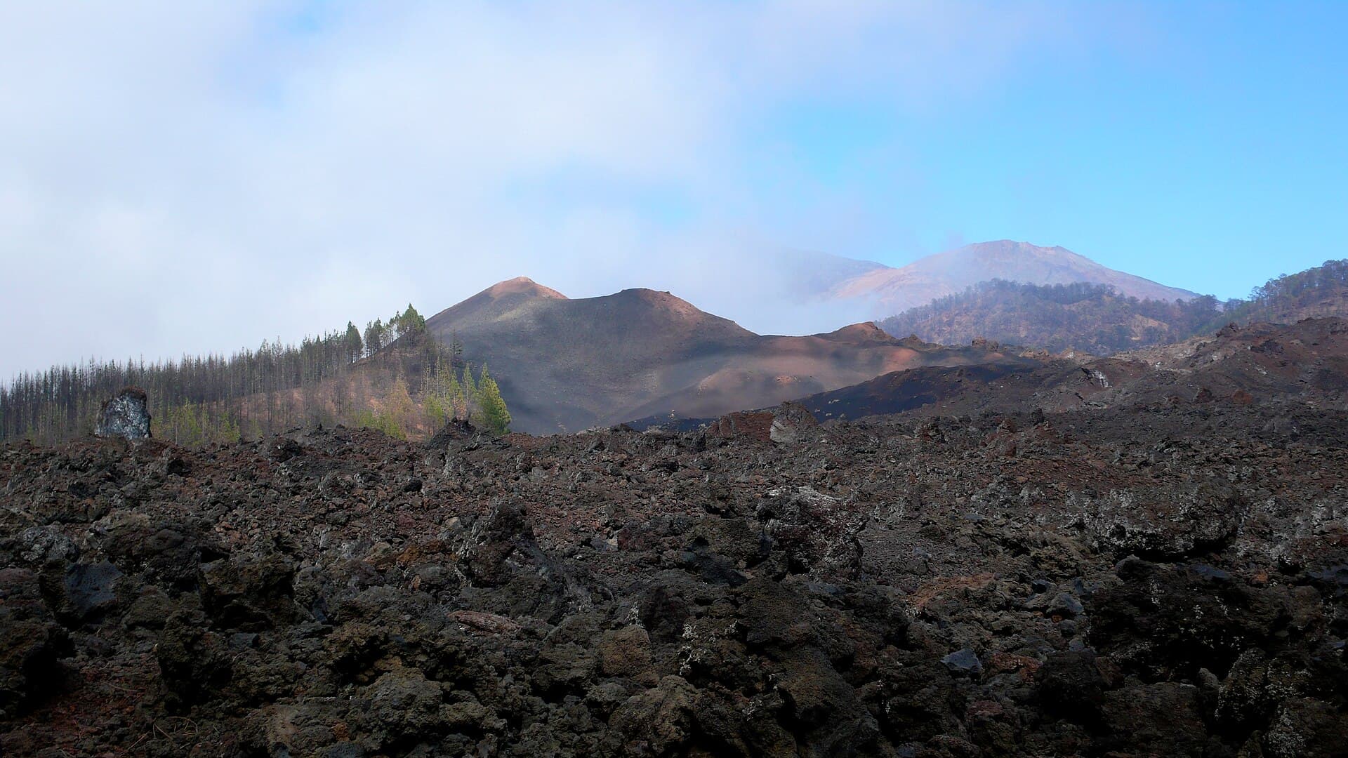
This protected area preserves the dramatic aftermath of Tenerife’s most recent eruption, which created the Chinyero cinder cone in 1909. The reserve showcases raw volcanic terrain alongside recovering pine woodland, offering hikers a tangible connection to the island’s geological story without the crowds of nearby Teide National Park.

What to See and Do

Key Landscapes

Walk the black and red lava flows that radiate from the central cone. The aa and pahoehoe textures remain clearly visible, illustrating different eruption styles. Scattered vents and hornitos rise from the fields, while Canary Island pines (Pinus canariensis) have recolonized the margins, their deep roots stabilizing the slopes.

Hiking Trails

Several marked paths cross the reserve. The loop around the Chinyero cone provides close views of the crater rim and sweeping panoramas toward the Teno massif and the Atlantic. Longer routes connect with the GR-131 long-distance trail, allowing extended walks through alternating forest and lava. Carry a map; signage is minimal once you leave the main access points.

Wildlife and Plants

Listen for the Tenerife blue chaffinch and look for the endemic Canary Islands lizard basking on warm rocks. In spring, the understory blooms with Echium and Cistus species adapted to volcanic soils.

Getting There

The reserve lies between the villages of El Tanque and Santiago del Teide. Drivers can reach trailheads via the TF-82 road; parking areas sit at the forest edge. Public buses from Puerto de la Cruz or Los Cristianos stop in nearby towns, from which a short taxi or additional walk reaches the entrance. No direct shuttle operates inside the reserve.

Best Time to Visit

Winter and spring offer the most comfortable temperatures and clearer skies for photography. Summer brings intense sun on exposed lava; early morning starts are essential. After heavy rain, some trails become slippery with fine volcanic ash.

Nearby Attractions

Combine a visit with the Masca gorge hike to the west or the coastal paths of Playa de la Enramada. The historic town of Garachico, with its volcanic-stone architecture and natural pools, lies a short drive north.

Visitor tips

  • Stay on marked trails to protect fragile lava surfaces and avoid hidden crevices.
  • Bring at least two liters of water per person; shade is scarce on the lava fields.
  • Wear sturdy hiking boots with good grip; volcanic rock is sharp and unstable in places.

Frequently asked questions

Can I camp inside the reserve?+

No camping or overnight stays are permitted; the reserve closes at dusk and is strictly day-use only.

Are dogs allowed on the trails?+

Dogs are not permitted to protect ground-nesting birds and the fragile ecosystem.

Is the hike suitable for children?+

The shorter cone loop can be managed by older children with proper footwear, but the uneven lava makes it unsuitable for very young kids or strollers.

Do I need a permit to visit?+

No special permit is required for standard hiking on marked paths.

What happens if the weather turns bad?+

Trails can become hazardous in fog or heavy rain; check the forecast and turn back if visibility drops.

Share
Google Maps Apple Maps Directions

Image: Mataparda · CC BY 3.0 · via Wikimedia Commons

Keep reading

Nearby & related

All stories
P
Santa Cruz de Tenerife Province

Playa de Bajamar: Tenerife’s Rugged Black-Sand Beach and Natural Pools

Find calm volcanic shores, dramatic cliffs, and tide-fed rock pools on Tenerife’s wild northern coast.

12 November 2026
Playa de Benijo: Tenerife’s Rugged Black-Sand Beach in the Anaga Mountains
Santa Cruz de Tenerife Province

Playa de Benijo: Tenerife’s Rugged Black-Sand Beach in the Anaga Mountains

A dramatic pebble cove backed by steep cliffs and Atlantic waves, offering hikers and photographers an untamed slice of…

12 November 2026
Playa de las Vistas: Tenerife’s Golden-Sand Family Beach in Los Cristianos
Santa Cruz de Tenerife Province

Playa de las Vistas: Tenerife’s Golden-Sand Family Beach in Los Cristianos

A calm, accessible stretch of imported golden sand with a lively promenade, ideal for swimming and relaxed days on…

12 November 2026