Skip to content
Plan & Tour
DestinationsItinerariesTravel BlogAboutContact
0Sign inPlan a trip
Plan & TourPlan & Tour

Travel guides, destination inspiration and curated itineraries for Canada, the USA and beyond, plus a free tool to plan your own day-by-day trip.

Get travel inspiration

Explore

  • All Destinations
  • Curated Itineraries
  • Travel Blog
  • Plan a Trip

Topics

  • Hiking & Nature
  • Food & Drink
  • City Breaks
  • Budget Travel

Company

  • About Us
  • Contact
  • Privacy Policy
  • Terms of Service

© 2026 Plan & Tour. Built for travellers.

Discover the world, one trip at a time.

Pitt River: Exploring British Columbia’s Scenic Waterway Near Vancouver
  1. Home
  2. Destinations
  3. British Columbia
  4. Pitt River: Exploring British Columbia’s Scenic Waterway Near Vancouver
River

Pitt River: Exploring British Columbia’s Scenic Waterway Near Vancouver

A peaceful river ideal for fishing, paddling, and wildlife viewing in the Lower Mainland’s forested landscape.

British ColumbiaUpdated 1 July 2026

Introduction to Pitt River

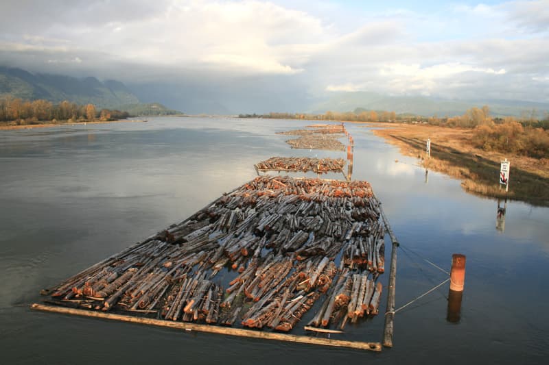
The Pitt River flows through the forested lowlands of British Columbia’s Lower Mainland, connecting the vast Pitt Lake with the Fraser River. Its calm stretches and dramatic mountain backdrop make it a rewarding destination for visitors seeking nature without the crowds of more famous BC waterways. The river’s 25-kilometre length passes through a mix of wetlands and temperate rainforest, supporting strong runs of salmon and steelhead that draw anglers year after year.

What to See and Do

Fishing the Pitt

Anglers target chinook, coho, and pink salmon in late summer and fall, while winter steelhead provide action from December through March. Drift fishing from boats or shore casting at established pullouts yields the best results. Always check current fishing regulations through provincial resources before heading out.

Paddling and Boating

Kayakers and canoeists launch at several informal access points to explore both the river and the adjacent Pitt Lake, one of the largest freshwater tidal lakes in the world. The flat water and protected setting suit beginners, while stronger paddlers can venture toward Widgeon Creek for multi-day trips. Motorized boats are permitted but should watch for log debris after heavy rains.

Wildlife and Scenery

Bald eagles, herons, and black bears frequent the riverbanks, especially during salmon spawning season. Short hikes along dike trails near the mouth offer elevated views of the valley and surrounding peaks of Golden Ears Provincial Park.

How to Get There

From Vancouver, drive east on Highway 7 (Lougheed Highway) through Maple Ridge and turn north on 203rd Street or Neaves Road to reach river access points. The journey takes roughly 45 minutes under normal traffic. Public transit options are limited, so most visitors arrive by car; parking is available at several roadside pullouts and regional park lots.

Best Time to Visit

Late spring through early fall offers the most comfortable conditions for paddling and fishing. Peak salmon runs occur from August to October, while winter visits appeal to steelhead anglers prepared for cooler temperatures and occasional fog. Avoid periods of heavy rainfall when water levels rise quickly and debris increases.

Nearby Attractions

  • Golden Ears Provincial Park for hiking and camping
  • Widgeon Marsh Regional Park for birdwatching trails
  • Maple Ridge’s historic downtown for supplies and dining
  • Alouette Lake for additional boating opportunities

Visitor tips

  • Launch early in the day to avoid afternoon winds on Pitt Lake and to secure limited roadside parking.
  • Carry a tide chart; Pitt Lake experiences noticeable tidal fluctuations that affect river levels and currents near the lake outlet.
  • Wear a personal flotation device at all times on the water and watch for submerged logs, especially after rain.
  • Pack out all trash and respect private property along the riverbanks.

Frequently asked questions

Is Pitt River good for salmon fishing?+

Yes, the river supports seasonal runs of chinook, coho, and pink salmon. Success is highest from late August through October when fish move upstream from the Fraser River.

Can beginners kayak on Pitt River?+

The lower river and Pitt Lake offer calm, protected water suitable for novice paddlers, though strong outgoing tides near the lake can create noticeable current.

Are there hiking trails right along the river?+

Dike trails near the river mouth provide easy walking with scenic views. More substantial hikes are available a short drive away in Golden Ears Provincial Park.

How far is Pitt River from Vancouver?+

The main access points lie approximately 45 minutes east of central Vancouver by car via Highway 7.

Do I need a license to fish the Pitt River?+

A valid British Columbia freshwater fishing licence is required, along with any applicable salmon conservation tags. Regulations change seasonally, so verify current rules before fishing.

Share
Google Maps Apple Maps Directions

Image: Quant08 · CC BY-SA 3.0 · via Wikimedia Commons

Keep reading

Nearby & related

All stories
Chilkat River: Bald Eagle Capital Along the BC-Alaska Border
British Columbia

Chilkat River: Bald Eagle Capital Along the BC-Alaska Border

Float through salmon-rich waters teeming with eagles and bears in one of North America’s premier wildlife corridors.

1 July 2026
Similkameen River: A Scenic Waterway Through British Columbia’s Southern Valleys
British Columbia

Similkameen River: A Scenic Waterway Through British Columbia’s Southern Valleys

Follow the Similkameen River through dramatic canyons, fertile orchards, and quiet parks in the heart of the Similkameen…

1 July 2026
Adams River: Witnessing British Columbia’s Legendary Sockeye Salmon Migration
British Columbia

Adams River: Witnessing British Columbia’s Legendary Sockeye Salmon Migration

Discover the dramatic sockeye salmon runs, clear waters, and surrounding forests of Adams River in British Columbia’s…

1 July 2026