Skip to content
Plan & Tour
DestinationsItinerariesTravel BlogAboutContact
0Sign inPlan a trip
Plan & TourPlan & Tour

Travel guides, destination inspiration and curated itineraries for Canada, the USA and beyond, plus a free tool to plan your own day-by-day trip.

Get travel inspiration

Explore

  • All Destinations
  • Curated Itineraries
  • Travel Blog
  • Plan a Trip

Topics

  • Hiking & Nature
  • Food & Drink
  • City Breaks
  • Budget Travel

Company

  • About Us
  • Contact
  • Privacy Policy
  • Terms of Service

© 2026 Plan & Tour. Built for travellers.

Discover the world, one trip at a time.

Pender Island: A Peaceful Retreat in British Columbia’s Southern Gulf Islands
  1. Home
  2. Destinations
  3. British Columbia
  4. Pender Island: A Peaceful Retreat in British Columbia’s Southern Gulf Islands
Island

Pender Island: A Peaceful Retreat in British Columbia’s Southern Gulf Islands

Discover quiet beaches, forest trails, and a relaxed island pace on this car-accessible Gulf Island.

British ColumbiaUpdated 1 July 2026

Why Pender Island Stands Out

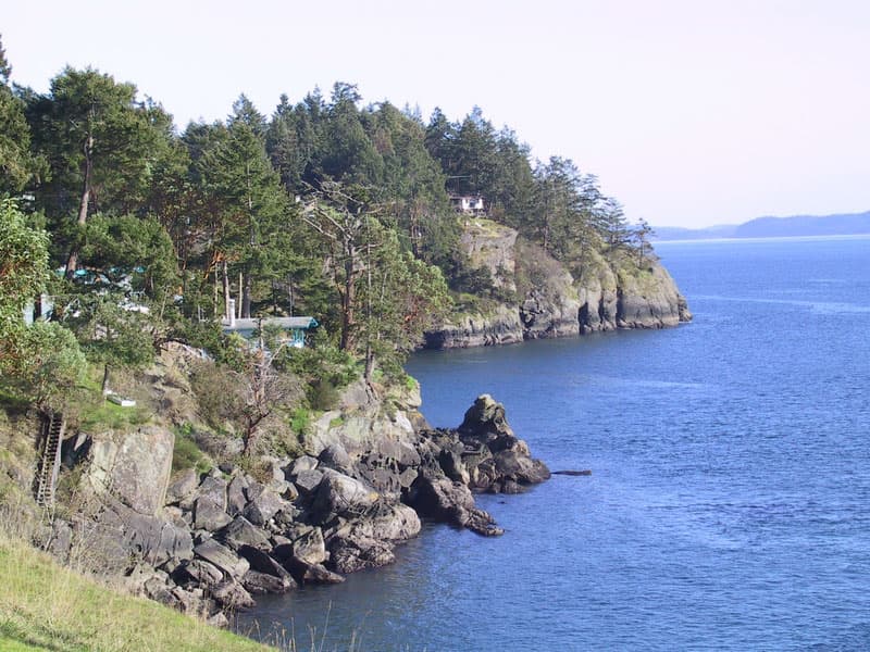
Pender Island sits in the Southern Gulf Islands archipelago between Vancouver and Victoria. Its two halves, joined by a single bridge, offer a compact yet varied landscape of sheltered coves, rocky headlands, and second-growth forest. The island’s small population and limited commercial development create a noticeably slower rhythm than nearby Salt Spring or the larger cities.

Things to See and Do

Beaches and Shoreline

Beaches here tend to be small and sheltered. Mortimer Spit provides easy water access for kayakers and swimmers, while Gowlland Point offers dramatic views across Boundary Pass on clear days. Many coves are reached by short trails through arbutus and fir.

Trails and Parks

The Pender Island Parks system maintains several accessible hikes. Mount Norman Regional Park climbs to the island’s highest point with panoramic views over the Strait of Georgia. Enchanted Forest Trail winds through mossy woodland on the north end. Most routes are moderate and suitable for half-day outings.

Local Food and Drink

Small farms and wineries dot the island. Visitors often stop at roadside stands for seasonal produce or visit one of the two wineries for tastings. The Saturday farmers’ market runs spring through fall and features local cheeses, baked goods, and crafts.

How to Get There

BC Ferries runs frequent sailings from Tsawwassen on the mainland and Swartz Bay on Vancouver Island to Otter Bay on Pender. Reservations are strongly recommended in summer. Once on the island, a car or bicycle is the most practical way to explore; public transit is minimal.

Best Time to Visit

Late spring and early fall offer the best balance of mild weather and fewer crowds. Summer brings longer days and warmer water but increased ferry traffic. Winter visits appeal to those seeking solitude, though some businesses close and rain is frequent.

Nearby Islands

Day trips to Saturna, Mayne, or North Pender’s close neighbor South Pender are straightforward by ferry or water taxi. Each offers its own character while sharing the same quiet Gulf Islands atmosphere.

Visitor tips

  • Reserve ferry travel in advance during peak season to avoid long waits at the terminal.
  • Pack layers and sturdy footwear; trails can be muddy and weather changes quickly.
  • Support local businesses by buying produce at farm stands and refilling water bottles rather than buying single-use plastics.

Frequently asked questions

Do I need a car on Pender Island?+

A vehicle is helpful for reaching trailheads and beaches, but cyclists and those staying centrally can manage with a bike or limited taxi service.

Are there many restaurants on Pender Island?+

Dining options are limited and casual. Expect farm-to-table cafu00e9s, a pub, and seasonal food trucks rather than fine dining.

Is Pender Island good for families?+

Yes, the calm beaches and short hiking trails suit children, though there are no large playgrounds or amusement facilities.

Can I camp on Pender Island?+

Camping is available at designated parks and a few private sites; reservations are required at the most popular locations.

Are there bears or dangerous wildlife?+

Black bears are occasionally sighted; store food properly and make noise on trails. There are no dangerous snakes or large predators.

Share
Google Maps Apple Maps Directions

Image: No machine-readable author provided. Tawker assumed (based on copyright claims). · CC BY 2.5 · via Wikimedia Commons

Keep reading

Nearby & related

All stories
Chilkat River: Bald Eagle Capital Along the BC-Alaska Border
British Columbia

Chilkat River: Bald Eagle Capital Along the BC-Alaska Border

Float through salmon-rich waters teeming with eagles and bears in one of North America’s premier wildlife corridors.

1 July 2026
Similkameen River: A Scenic Waterway Through British Columbia’s Southern Valleys
British Columbia

Similkameen River: A Scenic Waterway Through British Columbia’s Southern Valleys

Follow the Similkameen River through dramatic canyons, fertile orchards, and quiet parks in the heart of the Similkameen…

1 July 2026
Adams River: Witnessing British Columbia’s Legendary Sockeye Salmon Migration
British Columbia

Adams River: Witnessing British Columbia’s Legendary Sockeye Salmon Migration

Discover the dramatic sockeye salmon runs, clear waters, and surrounding forests of Adams River in British Columbia’s…

1 July 2026


