Skip to content
Plan & Tour
DestinationsItinerariesTravel BlogAboutContact
0Sign inPlan a trip
Plan & TourPlan & Tour

Travel guides, destination inspiration and curated itineraries for Canada, the USA and beyond, plus a free tool to plan your own day-by-day trip.

Get travel inspiration

Explore

  • All Destinations
  • Curated Itineraries
  • Travel Blog
  • Plan a Trip

Topics

  • Hiking & Nature
  • Food & Drink
  • City Breaks
  • Budget Travel

Company

  • About Us
  • Contact
  • Privacy Policy
  • Terms of Service

© 2026 Plan & Tour. Built for travellers.

Discover the world, one trip at a time.

Mount Pleasant: Panoramic Views Over Canberra
  1. Home
  2. Destinations
  3. Australian Capital Territory
  4. Mount Pleasant: Panoramic Views Over Canberra
Mountain

Mount Pleasant: Panoramic Views Over Canberra

Hike this accessible peak in the Australian Capital Territory for sweeping city vistas and quiet bushland trails.

Australian Capital TerritoryUpdated 17 September 2026

Why Visit Mount Pleasant

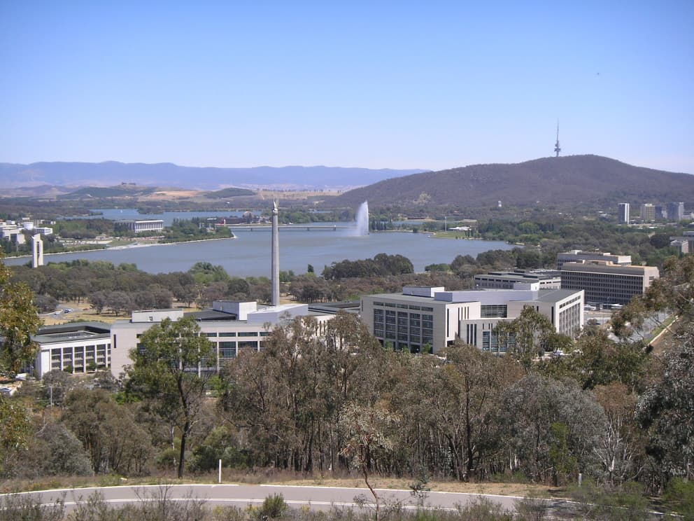
Mount Pleasant rises just north of Canberra’s city centre, providing one of the easiest ways to gain elevation and see the layout of the Australian Capital Territory. The summit delivers uninterrupted views across Lake Burley Griffin, the Parliamentary Triangle, Black Mountain and the Brindabella Ranges, all within a short climb from suburban streets.

Getting There

Drive via Fairbairn Avenue or Limestone Avenue and park at the small lot off General Bridges Drive. Several ACTION bus routes stop within 400 metres of the trailhead. Cyclists can follow the dedicated path that runs alongside the lake and then climbs steadily through the reserve. The mountain forms part of the Canberra Nature Park network, so entry is free and gates remain open at all times.

Walking Tracks and Activities

Two main tracks lead to the 659-metre summit. The shorter western path is a steady gravel climb of about 25 minutes. The eastern loop via the old reservoir adds distance and passes through stands of yellow box and red stringybark. Both routes are well signed and suitable for most fitness levels. At the top, a cleared area with a trig point and bench offers the best vantage point for photography and picnics. Early morning visits often reveal kangaroos grazing on the lower slopes.

Best Time to Visit

Autumn (March to May) and spring (September to November) bring mild daytime temperatures and fewer insects. Summer mornings are still pleasant before the heat builds, while winter walks reward visitors with crisp air and occasional light snow on the distant Brindabellas. Avoid the summit during strong westerly winds, which are common in the region.

Nearby Attractions

Combine a visit with the Australian War Memorial, only a five-minute drive away. Mount Ainslie lies immediately to the east and can be linked via a connecting fire trail. Lake Burley Griffin’s northern shore is perfect for a post-walk coffee or kayak rental. The Australian National University campus and Civic’s restaurants are a short downhill stroll or bus ride from the mountain’s base.

Visitor tips

  • Carry at least one litre of water per person; there are no refill points on the mountain.
  • Wear sturdy shoes with good gripu2014sections of the track become loose gravel after rain.
  • Check the ACT Emergency Services app for any park closures before heading out, especially on total fire ban days.

Frequently asked questions

How long does the walk to the top take?+

Most visitors reach the summit in 25u201335 minutes from the main car park; allow an hour for the longer eastern loop.

Is Mount Pleasant suitable for children?+

Yes, the shorter western track is manageable for school-age children with adult supervision; strollers are not practical beyond the first 100 metres.

Are dogs allowed on the mountain?+

Dogs on leads are permitted on the formed tracks within Canberra Nature Park.

What facilities are available at the summit?+

There are no toilets or water points; the only infrastructure is a trig point and a single bench.

Can I cycle to the summit?+

Mountain bikes are allowed on the fire trails but the steep, loose surface near the top is challenging; most riders leave bikes at the lower car park.

Share
Google Maps Apple Maps Directions

Image: Nick Dowling at English Wikipedia · CC BY-SA 3.0 · via Wikimedia Commons

Keep reading

Nearby & related

All stories
A
Australian Capital Territory

Australians of the Year Walk: Canberra’s Lakeside Tribute to National Achievers

A peaceful foreshore path in Canberra honouring every Australian of the Year with permanent plaques and stories.

17 September 2026
Cotter River: Canberra’s Wild Waterway for Hiking, Fishing and Picnics
Australian Capital Territory

Cotter River: Canberra’s Wild Waterway for Hiking, Fishing and Picnics

Flowing through Namadgi National Park, the Cotter River offers clear trout streams, riverside campsites and easy day…

17 September 2026
Mount Franklin: Summit Hikes in the Brindabella Ranges
Australian Capital Territory

Mount Franklin: Summit Hikes in the Brindabella Ranges

Tackle the rugged trails and sweeping alpine views at this prominent peak in the Australian Capital Territory.

17 September 2026