Skip to content
Plan & Tour
DestinationsItinerariesTravel BlogAboutContact
0Sign inPlan a trip
Plan & TourPlan & Tour

Travel guides, destination inspiration and curated itineraries for Canada, the USA and beyond, plus a free tool to plan your own day-by-day trip.

Get travel inspiration

Explore

  • All Destinations
  • Curated Itineraries
  • Travel Blog
  • Plan a Trip

Topics

  • Hiking & Nature
  • Food & Drink
  • City Breaks
  • Budget Travel

Company

  • About Us
  • Contact
  • Privacy Policy
  • Terms of Service

© 2026 Plan & Tour. Built for travellers.

Discover the world, one trip at a time.

Mount Arrowsmith: Hiking Vancouver Island’s Signature Peak
  1. Home
  2. Destinations
  3. British Columbia
  4. Mount Arrowsmith: Hiking Vancouver Island’s Signature Peak
Mountain

Mount Arrowsmith: Hiking Vancouver Island’s Signature Peak

Explore the rugged trails, sweeping island views, and quiet subalpine terrain of this prominent British Columbia summit.

British ColumbiaUpdated 31 July 2026

Why Mount Arrowsmith Stands Out

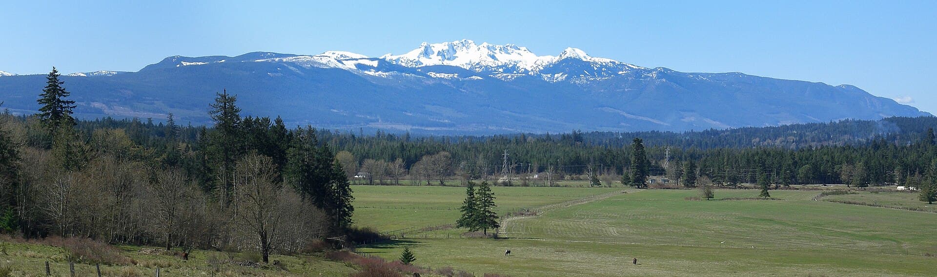
Mount Arrowsmith rises prominently above central Vancouver Island, offering hikers and sightseers a rare combination of accessible subalpine terrain and 360-degree panoramas that stretch from the Strait of Georgia to the peaks of the Beaufort Range. Its location between Port Alberni and Qualicum Beach makes it a natural draw for travelers seeking a full-day mountain outing without venturing into remote backcountry.

Trails and What to Expect on the Mountain

The most popular route follows the Arrowsmith Trail from the Mount Arrowsmith Trailhead near Highway 4. The path climbs steadily through old-growth forest before emerging into open meadows dotted with heather and small tarns. Beyond the meadows the grade steepens over loose rock and occasional snow patches even in midsummer, culminating at the true summit with views of Mount Baker on clear days and the full length of Alberni Inlet.

A shorter but steeper option begins from the south side via logging roads near the Cameron River valley; this approach suits experienced hikers comfortable with route-finding. Both routes reward early starts, as afternoon clouds frequently obscure the summit.

Best Time to Visit

July through early October provides the most reliable snow-free conditions on the upper slopes. Wildflowers peak in late July and early August, while September brings cooler temperatures and fewer insects. Winter visits are possible for experienced backcountry travelers with avalanche awareness, but the mountain’s north-facing aspects hold snow late into spring.

Getting There and Nearby Attractions

From Nanaimo, follow Highway 19 north then Highway 4 west toward Port Alberni; the main trailhead turnoff is well signed roughly 25 kilometres west of Qualicum Beach. A high-clearance vehicle is advisable for the final gravel section. Visitors often combine the hike with a stop at nearby Cathedral Grove or a picnic at Little Qualicum Falls Provincial Park, both less than 30 minutes away by car.

Practical Considerations for a Safe Visit

  • Cell service is unreliable above the trailhead; download offline maps in advance.
  • Weather can change rapidly; carry layers, rain shell, and extra food even on sunny forecasts.
  • Respect the watershed—leave no trace and pack out all waste.

Visitor tips

  • Start hiking by 8 a.m. to avoid afternoon cloud build-up on the summit.
  • Carry at least two litres of water per person; there are no reliable sources above the lower forest.
  • Check current road conditions with the local forestry office before driving the final gravel approach.

Frequently asked questions

How difficult is the hike to the summit of Mount Arrowsmith?+

The standard route is a strenuous full-day outing with significant elevation gain and some exposed scrambling near the top; it is best suited to fit hikers comfortable with 8u201310 hours on trail.

Do I need a vehicle with four-wheel drive to reach the trailhead?+

A high-clearance two-wheel-drive vehicle can usually manage the main access road in dry summer conditions, but a four-wheel-drive vehicle is safer after rain or early in the season.

Are there any facilities at the trailhead or on the mountain?+

There are no toilets, water, or shelters at the trailhead or along the route; plan to be completely self-sufficient.

Can I see the ocean from the summit?+

Yes, on clear days the view includes the Strait of Georgia, parts of the mainland Coast Mountains, and the full sweep of Alberni Inlet.

Is Mount Arrowsmith suitable for children?+

Only very fit older children experienced with long hikes should attempt the full summit route; shorter forest sections near the trailhead offer easier options for younger hikers.

Share
Google Maps Apple Maps Directions

Image: KenWalker kgw@lunar.ca · CC BY-SA 3.0 · via Wikimedia Commons

Keep reading

Nearby & related

All stories
Vedder River: Salmon Fishing, Paddling and Riverside Trails in British Columbia
British Columbia

Vedder River: Salmon Fishing, Paddling and Riverside Trails in British Columbia

A clear, productive river in the Fraser Valley offering consistent chinook and coho runs, easy paddling and quiet hiking…

1 August 2026
E
British Columbia

Englishman River: Waterfalls, Forests and Salmon Runs on Vancouver Island

Hike to dramatic waterfalls, swim in clear pools, and watch salmon spawn along this Vancouver Island river.

1 August 2026
B
British Columbia

Bella Coola River: Wilderness Fishing and Grizzly Viewing in British Columbia’s Great Bear Rainforest

This remote river in the Bella Coola Valley offers world-class steelhead and salmon fishing, abundant wildlife, and…

1 August 2026