Skip to content
Plan & Tour
DestinationsItinerariesTravel BlogAboutContact
0Sign inPlan a trip
Plan & TourPlan & Tour

Travel guides, destination inspiration and curated itineraries for Canada, the USA and beyond, plus a free tool to plan your own day-by-day trip.

Get travel inspiration

Explore

  • All Destinations
  • Curated Itineraries
  • Travel Blog
  • Plan a Trip

Topics

  • Hiking & Nature
  • Food & Drink
  • City Breaks
  • Budget Travel

Company

  • About Us
  • Contact
  • Privacy Policy
  • Terms of Service

© 2026 Plan & Tour. Built for travellers.

Discover the world, one trip at a time.

Mount Albert Edward: Hiking Vancouver Island’s Second-Highest Peak
  1. Home
  2. Destinations
  3. British Columbia
  4. Mount Albert Edward: Hiking Vancouver Island’s Second-Highest Peak
Mountain

Mount Albert Edward: Hiking Vancouver Island’s Second-Highest Peak

A rewarding alpine trek through Strathcona Provincial Park to sweeping summit views on Vancouver Island.

British ColumbiaUpdated 31 July 2026

Why Visit Mount Albert Edward

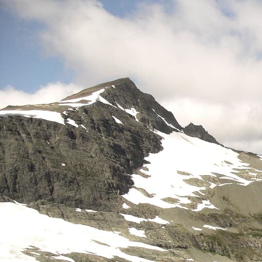
Mount Albert Edward rises prominently in central Vancouver Island’s Strathcona Provincial Park, offering hikers a true alpine experience without technical climbing. At 2,093 metres it ranks as the island’s second-highest summit after Golden Hinde, yet its broad, rounded top and accessible trail make it a classic objective for fit day hikers and overnight backpackers seeking expansive views of jagged peaks, turquoise tarns, and coastal ranges.

Getting There

The most common approach begins at the Paradise Meadows trailhead near Mount Washington Alpine Resort, reached by paved road from Courtenay or Campbell River. From the parking area, hikers follow well-marked park trails past Battleship Lake and Mount Brooks before ascending the steady switchbacks that lead to the open alpine bowl beneath the summit. Those arriving by ferry from the mainland typically base themselves in Courtenay or Campbell River for an early start.

Best Time to Visit

July through September provides the most reliable snow-free conditions on the upper slopes. Early summer can still hold lingering cornices, while October brings the first heavy snows. Clear, stable weather windows are essential; sudden fog or afternoon thunderstorms are common on the exposed plateau.

The Hike and What to Expect

The route traverses subalpine meadows dotted with heather and dwarf fir before climbing into rocky terrain. The final ascent crosses a broad saddle with 360-degree panoramas that include the Comox Glacier, distant Strait of Georgia, and a sea of Vancouver Island summits. Wildlife such as Vancouver Island marmots and black bears may appear; maintain distance and store food properly. Overnight options exist at designated backcountry campsites near Circlet Lake or Moat Lake for those wanting sunrise from the summit.

Nearby Attractions

Strathcona Provincial Park offers additional objectives including the shorter walk to Lake Helen Mackenzie and longer traverses toward Mount Albert Edward’s neighbours. The Forbidden Plateau area to the south provides further lake-dotted hiking, while the nearby Mount Washington resort offers chairlift-accessed summer trails for those seeking easier options.

Visitor tips

  • Carry more water than you think you need; alpine streams are scarce on the final slopes.
  • Bring layered clothing and a shellu2014wind and temperature drops are sudden above treeline.
  • Use a map and compass or GPS; the open plateau can disorient hikers in low visibility.

Frequently asked questions

How difficult is the hike to Mount Albert Edward?+

It is a strenuous full-day outing with significant elevation gain and rocky terrain; most hikers rate it as challenging but non-technical.

Do I need a permit to hike Mount Albert Edward?+

No day-use permit is required, but backcountry camping in Strathcona Provincial Park requires a valid park permit obtained in advance.

Can beginners reach the summit?+

The route is best suited to experienced hikers with good fitness; novices should consider shorter park trails first.

Is Mount Albert Edward suitable for winter hiking or snowshoeing?+

Winter travel demands avalanche awareness, ice axes, and crampons; only experienced mountaineers should attempt it outside summer.

Are there facilities at the trailhead?+

The Paradise Meadows trailhead has basic parking and vault toilets; no potable water or services are available.

Share
Google Maps Apple Maps Directions

Image: Smably (talk) (Uploads) · Public domain · via Wikimedia Commons

Keep reading

Nearby & related

All stories
Wedgemount Lake: Hiking to a Turquoise Alpine Gem Near Whistler
British Columbia

Wedgemount Lake: Hiking to a Turquoise Alpine Gem Near Whistler

A rewarding backcountry trek leads to glacial waters and sweeping mountain views in British Columbia’s Coast Range.

8 August 2026
Yellowhead Lake: Turquoise Waters and Mountain Backdrops in Mount Robson Provincial Park
British Columbia

Yellowhead Lake: Turquoise Waters and Mountain Backdrops in Mount Robson Provincial Park

This serene lake in British Columbia’s Rockies delivers quiet paddling, trout fishing, and easy access to dramatic peaks…

8 August 2026
Swindle Island: Remote Wilderness on British Columbia’s Central Coast
British Columbia

Swindle Island: Remote Wilderness on British Columbia’s Central Coast

Discover pristine rainforest, marine wildlife, and quiet anchorages on this secluded island in the Inside Passage.

8 August 2026


