
Skip to content
Plan & Tour
DestinationsItinerariesTravel BlogAboutContact
0Sign inPlan a trip
Plan & TourPlan & Tour

Travel guides, destination inspiration and curated itineraries for Canada, the USA and beyond, plus a free tool to plan your own day-by-day trip.

Get travel inspiration

Explore

  • All Destinations
  • Curated Itineraries
  • Travel Blog
  • Plan a Trip

Topics

  • Hiking & Nature
  • Food & Drink
  • City Breaks
  • Budget Travel

Company

  • About Us
  • Contact
  • Privacy Policy
  • Terms of Service

© 2026 Plan & Tour. Built for travellers.

Discover the world, one trip at a time.

Liard River: Soaking in British Columbia’s Wild Northern Waters
  1. Home
  2. Destinations
  3. British Columbia
  4. Liard River: Soaking in British Columbia’s Wild Northern Waters
River

Liard River: Soaking in British Columbia’s Wild Northern Waters

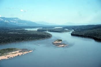
Follow the Liard River through remote boreal forest to its renowned hot springs and sweeping wilderness landscapes.

British ColumbiaUpdated 22 June 2026

Why the Liard River Draws Visitors

The Liard River carves through northern British Columbia’s boreal forest, offering clear water, abundant wildlife, and direct access to one of Canada’s most accessible natural hot springs. Travelers on the Alaska Highway stop here for the contrast between cold river currents and steaming pools surrounded by old-growth spruce.

What to See and Do

Liard River Hot Springs Provincial Park

Two main boardwalk-accessed pools sit a short walk from the highway. The Alpha Pool maintains a steady 42 °C while the cooler Beta Pool allows longer soaks. Boardwalks protect the delicate tufa formations and keep visitors above the marshy ground.

River Activities

  • Cast for northern pike and Arctic grayling from shore or by canoe near the highway bridge.
  • Launch kayaks or packrafts for day trips downstream; the current is gentle but watch for log jams after high water.
  • Watch for moose, bears, and sandhill cranes along the gravel bars at dawn and dusk.

How to Get There

The river crosses the Alaska Highway at kilometre 799. Drive north from Fort Nelson (roughly 290 km) or south from Watson Lake, Yukon (about 230 km). A large parking area and day-use facilities sit immediately beside the highway; no vehicle reservations are required.

Best Time to Visit

June through early September brings the longest days, open highway access, and active wildlife. The hot springs remain open year-round, though winter visits require ice cleats and awareness of extreme cold. Spring runoff can make river levels high and murky until mid-July.

Nearby Attractions

  • Stone Mountain Provincial Park offers alpine hiking and Summit Lake viewpoints 100 km north.
  • Muncho Lake Provincial Park features turquoise water and mineral licks 140 km south.
  • Short side roads lead to the Toad River and its dramatic canyon overlooks.

Visitor tips

  • Bring bug repellent and long clothing; mosquitoes and blackflies are intense from June through August.
  • Pack a cooler and water shoes for the hot springs; the wooden change rooms have limited space.
  • Fill the fuel tank in Fort Nelson or Watson Lakeu2014services along this stretch of highway are sparse.

Frequently asked questions

Can you swim in the Liard River itself?+

Yes, but the water stays cold even in summer. Most visitors combine a quick dip in the river with a longer soak in the adjacent hot springs.

Are the hot springs free to enter?+

There is no entry fee for day use at Liard River Hot Springs Provincial Park.

Is the area suitable for children?+

The boardwalks and main pools are family-friendly, but supervise children closely around the riveru2019s strong currents and slippery rocks.

Do I need a guide for river activities?+

Experienced paddlers can explore independently, but first-time visitors or those planning multi-day trips should arrange a local outfitter for safety and logistics.

Are there camping options right at the river?+

A small provincial park campground sits beside the hot springs with basic sites; reservations are recommended in peak summer months.

Share
Google Maps Apple Maps Directions

Image: The original uploader was Löwenzahn1 at German Wikipedia. · Public domain · via Wikimedia Commons

Keep reading

Nearby & related

All stories
Chilkat River: Bald Eagle Capital Along the BC-Alaska Border
British Columbia

Chilkat River: Bald Eagle Capital Along the BC-Alaska Border

Float through salmon-rich waters teeming with eagles and bears in one of North America’s premier wildlife corridors.

1 July 2026
Similkameen River: A Scenic Waterway Through British Columbia’s Southern Valleys
British Columbia

Similkameen River: A Scenic Waterway Through British Columbia’s Southern Valleys

Follow the Similkameen River through dramatic canyons, fertile orchards, and quiet parks in the heart of the Similkameen…

1 July 2026
Adams River: Witnessing British Columbia’s Legendary Sockeye Salmon Migration
British Columbia

Adams River: Witnessing British Columbia’s Legendary Sockeye Salmon Migration

Discover the dramatic sockeye salmon runs, clear waters, and surrounding forests of Adams River in British Columbia’s…

1 July 2026

