Skip to content
Plan & Tour
DestinationsItinerariesTravel BlogAboutContact
0Sign inPlan a trip
Plan & TourPlan & Tour

Travel guides, destination inspiration and curated itineraries for Canada, the USA and beyond, plus a free tool to plan your own day-by-day trip.

Get travel inspiration

Explore

  • All Destinations
  • Curated Itineraries
  • Travel Blog
  • Plan a Trip

Topics

  • Hiking & Nature
  • Food & Drink
  • City Breaks
  • Budget Travel

Company

  • About Us
  • Contact
  • Privacy Policy
  • Terms of Service

© 2026 Plan & Tour. Built for travellers.

Discover the world, one trip at a time.

Devils Paw: Climbing British Columbia’s Iconic Juneau Icefield Peak
  1. Home
  2. Destinations
  3. British Columbia
  4. Devils Paw: Climbing British Columbia’s Iconic Juneau Icefield Peak
Mountain

Devils Paw: Climbing British Columbia’s Iconic Juneau Icefield Peak

A remote, glaciated summit straddling the BC-Alaska border that rewards experienced mountaineers with sweeping icefield views.

British ColumbiaUpdated 1 July 2026

Why Devils Paw Stands Out

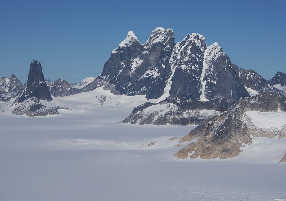
Devils Paw rises as the highest point of the Juneau Icefield, its distinctive double summit and steep rock faces creating one of the most recognizable landmarks along the BC-Alaska boundary. The peak’s isolation within a vast expanse of ice and snow makes it a compelling objective for climbers seeking both technical challenge and true wilderness immersion.

Reaching the Mountain

No roads lead to Devils Paw. Most visitors fly by helicopter from Juneau, Alaska, landing directly on the icefield near the base of the peak. Fixed-wing flights from Atlin, British Columbia, or Skagway can also position parties for ski-plane access when conditions allow. Once on the ice, travel is by ski or foot, often requiring crevasse navigation and route-finding across the icefield’s broad plateau.

Climbing Routes and Terrain

The standard ascent follows the southwest ridge, a mixed route of snow, ice, and exposed rock that demands glacier travel skills, crampon technique, and comfort with moderate rock climbing. The north face offers steeper ice and mixed lines for advanced parties. Because the mountain sits on the international border, climbers must carry appropriate identification and be prepared for possible customs inquiries upon return.

Essential Preparation

  • Strong glacier-travel and crevasse-rescue proficiency are mandatory.
  • Weather windows are short; multi-day storms can pin teams to camp for days.
  • All food, fuel, and shelter must be carried in and packed out.

Best Time to Visit

Prime conditions occur from late April through early July when snow bridges are still intact and daylight is long. Later in summer, crevasses open and rockfall increases. Winter ascents are possible but require greater commitment and specialized cold-weather experience.

Nearby Destinations

After a Devils Paw climb, many parties continue across the Juneau Icefield to other notable summits such as The Snowfield Peak or the Taku Towers. Lower-elevation options include exploring the historic mining trails around Atlin or taking a boat tour on Atlin Lake to view the surrounding peaks from the water.

Visitor tips

  • Hire a guide service familiar with the Juneau Icefield if your party lacks extensive glacier experience.
  • File a detailed trip plan with both Canadian and U.S. authorities because the peak lies on the border.
  • Pack extra fuel and foodu2014weather delays on the icefield are common and can extend trips by several days.

Frequently asked questions

Do I need a permit to climb Devils Paw?+

No special climbing permit is required, but visitors must follow standard backcountry regulations for the area and carry valid identification for border travel.

How technical is the climb?+

The standard route involves glacier travel, moderate snow and ice slopes, and some exposed rock scrambling; prior mountaineering experience is essential.

Can I reach Devils Paw by car or trail?+

No roads or maintained trails exist; access is exclusively by air, typically helicopter or ski-equipped plane from Juneau or Atlin.

What wildlife might I encounter?+

Bears are present on lower slopes and coastal approaches; keep a clean camp and carry bear spray on any overland sections.

Is cell service available near Devils Paw?+

There is no reliable cell coverage on the icefield; satellite communication devices are strongly recommended.

Share
Google Maps Apple Maps Directions

Image: Gillfoto · CC BY-SA 4.0 · via Wikimedia Commons

Keep reading

Nearby & related

All stories
Chilkat River: Bald Eagle Capital Along the BC-Alaska Border
British Columbia

Chilkat River: Bald Eagle Capital Along the BC-Alaska Border

Float through salmon-rich waters teeming with eagles and bears in one of North America’s premier wildlife corridors.

1 July 2026
Similkameen River: A Scenic Waterway Through British Columbia’s Southern Valleys
British Columbia

Similkameen River: A Scenic Waterway Through British Columbia’s Southern Valleys

Follow the Similkameen River through dramatic canyons, fertile orchards, and quiet parks in the heart of the Similkameen…

1 July 2026
Adams River: Witnessing British Columbia’s Legendary Sockeye Salmon Migration
British Columbia

Adams River: Witnessing British Columbia’s Legendary Sockeye Salmon Migration

Discover the dramatic sockeye salmon runs, clear waters, and surrounding forests of Adams River in British Columbia’s…

1 July 2026


