Skip to content
Plan & Tour
DestinationsItinerariesTravel BlogAboutContact
0Sign inPlan a trip
Plan & TourPlan & Tour

Travel guides, destination inspiration and curated itineraries for Canada, the USA and beyond, plus a free tool to plan your own day-by-day trip.

Get travel inspiration

Explore

  • All Destinations
  • Curated Itineraries
  • Travel Blog
  • Plan a Trip

Topics

  • Hiking & Nature
  • Food & Drink
  • City Breaks
  • Budget Travel

Company

  • About Us
  • Contact
  • Privacy Policy
  • Terms of Service

© 2026 Plan & Tour. Built for travellers.

Discover the world, one trip at a time.

Cheam Peak: Summit Views Over the Fraser Valley in British Columbia
  1. Home
  2. Destinations
  3. British Columbia
  4. Cheam Peak: Summit Views Over the Fraser Valley in British Columbia
Mountain

Cheam Peak: Summit Views Over the Fraser Valley in British Columbia

Hike this steep but short trail in the Cheam Range for sweeping vistas of the Cascades, Mount Baker, and the Fraser Valley.

British ColumbiaUpdated 31 July 2026

Why Cheam Peak Stands Out

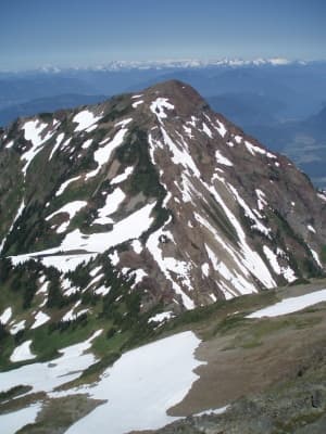
Cheam Peak rises prominently in the Cheam Range of British Columbia’s Cascade Mountains, delivering one of the most accessible high-elevation viewpoints near the Fraser Valley. From the 2,100-metre summit, hikers look north across the broad Fraser River valley toward Chilliwack and south to the jagged spires of the Border Peaks and the distinctive cone of Mount Baker. The mountain’s south-facing slopes and relatively short approach make it a favorite for day trips when longer alpine objectives remain snowbound.

Getting to the Trailhead

Drive east from Vancouver on Highway 1 to Chilliwack, then follow the Chilliwack Lake Road and turn onto the narrower Chipmunk Creek Forest Service Road. The final stretch is gravel and can be rough after winter; high-clearance vehicles handle it best, though most cars manage in dry conditions. Parking is limited at the signed trailhead, so arrive early on summer weekends.

The Hike to the Summit

The trail climbs steadily through second-growth forest before emerging onto open meadows and rocky slopes. Elevation gain is concentrated in the upper half, where switchbacks ease the grade but loose scree requires attention. At the top, a broad summit plateau offers sheltered spots for lunch and 360-degree views that include the entire Cheam Range to the east and the distant peaks of Manning Provincial Park on clear days. Most fit hikers complete the round trip in four to six hours.

What to Expect on the Trail

  • Steep grades and occasional loose rock near the top; trekking poles help on descent.
  • Wildflowers in July and August, followed by vibrant fall colors in September.
  • Possible snow patches into early summer; microspikes are useful in May and June.

Best Time to Visit

Late June through early October provides the most reliable snow-free conditions. July and August bring the longest days and warmest temperatures, while September offers cooler air and fewer bugs. Winter travel requires avalanche awareness and is best left to experienced parties with proper gear.

Nearby Destinations Worth Adding

Combine a Cheam Peak hike with a visit to Chilliwack Lake Provincial Park for shoreline walks or a stop at the Cultus Lake area for swimming and paddling. The same road network leads to other Cheam Range trails such as Mount Thom and Lady Peak, allowing multi-day exploration of the range without returning to the highway.

Visitor tips

  • Carry more water than you think you need; the trail is exposed in the upper sections with no reliable sources after the forest.
  • Check the current road and trail conditions with local forestry offices before driving the gravel section, especially after heavy rain.
  • Start early to secure parking and avoid afternoon thunderstorms common in the Cascades during summer.

Frequently asked questions

How difficult is the Cheam Peak hike?+

It is a strenuous day hike due to nearly 1,000 metres of elevation gain over a short distance, but the route is well-defined and suitable for experienced hikers with good fitness.

Is Cheam Peak suitable for beginners?+

Beginners should only attempt it with an experienced companion; the steep upper sections and loose rock can be intimidating for first-time hikers.

Can I camp on or near Cheam Peak?+

No established campsites exist at the summit. Overnight stays are possible at lower trailheads with proper permits where required, but the peak itself is a day-use destination.

Are dogs allowed on the trail?+

Dogs are permitted but must be kept under control on the exposed upper slopes where loose rock and steep drop-offs exist.

What gear should I bring beyond the basics?+

Sturdy hiking boots, trekking poles, extra layers for wind at the summit, and plenty of water are essential; binoculars enhance the views of distant peaks.

Share
Google Maps Apple Maps Directions

Image: Tsylos Michael F Coyle (Blue Toque), some rights reserved. · CC BY-SA 3.0 · via Wikimedia Commons

Keep reading

Nearby & related

All stories
Vedder River: Salmon Fishing, Paddling and Riverside Trails in British Columbia
British Columbia

Vedder River: Salmon Fishing, Paddling and Riverside Trails in British Columbia

A clear, productive river in the Fraser Valley offering consistent chinook and coho runs, easy paddling and quiet hiking…

1 August 2026
E
British Columbia

Englishman River: Waterfalls, Forests and Salmon Runs on Vancouver Island

Hike to dramatic waterfalls, swim in clear pools, and watch salmon spawn along this Vancouver Island river.

1 August 2026
B
British Columbia

Bella Coola River: Wilderness Fishing and Grizzly Viewing in British Columbia’s Great Bear Rainforest

This remote river in the Bella Coola Valley offers world-class steelhead and salmon fishing, abundant wildlife, and…

1 August 2026


