Skip to content
Plan & Tour
DestinationsItinerariesTravel BlogAboutContact
0Sign inPlan a trip
Plan & TourPlan & Tour

Travel guides, destination inspiration and curated itineraries for Canada, the USA and beyond, plus a free tool to plan your own day-by-day trip.

Get travel inspiration

Explore

  • All Destinations
  • Curated Itineraries
  • Travel Blog
  • Plan a Trip

Topics

  • Hiking & Nature
  • Food & Drink
  • City Breaks
  • Budget Travel

Company

  • About Us
  • Contact
  • Privacy Policy
  • Terms of Service

© 2026 Plan & Tour. Built for travellers.

Discover the world, one trip at a time.

Anahim Peak: Hiking the Remote Volcanic Summit in British Columbia’s Chilcotin
  1. Home
  2. Destinations
  3. British Columbia
  4. Anahim Peak: Hiking the Remote Volcanic Summit in British Columbia’s Chilcotin
Mountain

Anahim Peak: Hiking the Remote Volcanic Summit in British Columbia’s Chilcotin

Discover the stark volcanic landscapes and sweeping plateau views at Anahim Peak, a standout summit in central British Columbia's wilderness.

British ColumbiaUpdated 31 July 2026

Why Anahim Peak Stands Out

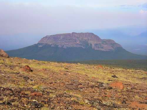
Anahim Peak rises as the highest point in the Anahim Volcanic Belt, a chain of ancient volcanic features that punctuate the Chilcotin Plateau. Its symmetrical cone shape and open alpine terrain offer hikers unobstructed 360-degree views across the Coast Mountains to the west and the rolling plateau to the east. The mountain’s remote location keeps crowds away, rewarding those who make the journey with a genuine sense of wilderness solitude.

Getting There

Access begins along Highway 20, the Bella Coola Road, which crosses the Chilcotin Plateau. From the community of Anahim Lake, travelers follow a network of active forestry roads that lead toward the mountain’s base. A high-clearance vehicle, preferably with four-wheel drive, is essential because road conditions change with weather and logging activity. The final approach involves a rough track that ends at a trailhead where the hike begins.

Best Time to Visit

July through early September provides the most reliable window for summit attempts. Snow lingers on north-facing slopes well into June, while September can bring early storms. Summer days are long, allowing hikers to start early and return before afternoon thunderstorms common in the interior mountains.

The Hike Itself

The route follows an old mining exploration trail that climbs steadily through subalpine forest before emerging onto open slopes. Above treeline the path becomes a straightforward walk-up over loose volcanic scree and hardy alpine meadows. Most fit hikers reach the summit in four to six hours round-trip. The final pitch requires careful footing but no technical climbing skills.

What to See and Do

From the summit cairn, clear days reveal the Rainbow Range to the south and the distant peaks of Tweedsmuir Provincial Park. Photographers favor the golden light of early morning or late evening when shadows accentuate the volcanic ridges. Wildflower displays peak in mid-July, with lupine and Indian paintbrush carpeting the lower meadows. Wildlife sightings may include grizzly bears, mountain caribou, and golden eagles riding thermals along the ridges.

Nearby Attractions

  • Anahim Lake offers fishing and a small float-plane base for scenic flights over the volcanic belt.
  • The Rainbow Range provides longer backpacking routes with similar volcanic geology.
  • Tweedsmuir Provincial Park lies a short drive west and features the dramatic Hunlen Falls and extensive trail networks.

Visitor tips

  • Carry extra fuel and spare tires; cell service is nonexistent beyond Anahim Lake.
  • Pack bear spray and practice proper food storage, as grizzlies frequent the area.
  • Check current forestry road status with local logging companies before departure, as active hauling can close sections without notice.

Frequently asked questions

How difficult is the hike to Anahim Peak?+

The trail is a steady but non-technical ascent suitable for experienced day hikers with good fitness; expect loose scree near the top and route-finding above treeline.

Do I need a 4x4 vehicle to reach the trailhead?+

A high-clearance four-wheel-drive vehicle is strongly recommended because forestry roads can be deeply rutted or muddy after rain.

Are there any facilities or water sources on the mountain?+

There are no facilities or reliable water sources above the trailhead; carry all drinking water and plan to filter from lower streams if needed.

Can I camp near Anahim Peak?+

Dispersed camping is possible at the trailhead or in nearby clearings, but no designated sites or services exist; practice Leave No Trace principles.

What wildlife should I watch for?+

Grizzly and black bears, mountain caribou, and wolves inhabit the region; make noise on the trail and store food properly at all times.

Share
Google Maps Apple Maps Directions

Image: nass5518 · CC BY 2.0 · via Wikimedia Commons

Keep reading

Nearby & related

All stories
Wedgemount Lake: Hiking to a Turquoise Alpine Gem Near Whistler
British Columbia

Wedgemount Lake: Hiking to a Turquoise Alpine Gem Near Whistler

A rewarding backcountry trek leads to glacial waters and sweeping mountain views in British Columbia’s Coast Range.

8 August 2026
Yellowhead Lake: Turquoise Waters and Mountain Backdrops in Mount Robson Provincial Park
British Columbia

Yellowhead Lake: Turquoise Waters and Mountain Backdrops in Mount Robson Provincial Park

This serene lake in British Columbia’s Rockies delivers quiet paddling, trout fishing, and easy access to dramatic peaks…

8 August 2026
Swindle Island: Remote Wilderness on British Columbia’s Central Coast
British Columbia

Swindle Island: Remote Wilderness on British Columbia’s Central Coast

Discover pristine rainforest, marine wildlife, and quiet anchorages on this secluded island in the Inside Passage.

8 August 2026


