Skip to content
Plan & Tour
DestinationsItinerariesTravel BlogAboutContact
0Sign inPlan a trip
Plan & TourPlan & Tour

Travel guides, destination inspiration and curated itineraries for Canada, the USA and beyond, plus a free tool to plan your own day-by-day trip.

Get travel inspiration

Explore

  • All Destinations
  • Curated Itineraries
  • Travel Blog
  • Plan a Trip

Topics

  • Hiking & Nature
  • Food & Drink
  • City Breaks
  • Budget Travel

Company

  • About Us
  • Contact
  • Privacy Policy
  • Terms of Service

© 2026 Plan & Tour. Built for travellers.

Discover the world, one trip at a time.

Toyo River: Scenic Walks and Local Life Along Aichi’s Eastern Waterway
  1. Home
  2. Destinations
  3. Aichi Prefecture
  4. Toyo River: Scenic Walks and Local Life Along Aichi’s Eastern Waterway
River

Toyo River: Scenic Walks and Local Life Along Aichi’s Eastern Waterway

Follow the Toyo River through quiet countryside and tidal reaches in Aichi Prefecture for relaxed nature and authentic regional experiences.

Aichi PrefectureUpdated 13 August 2026

Why the Toyo River Draws Visitors

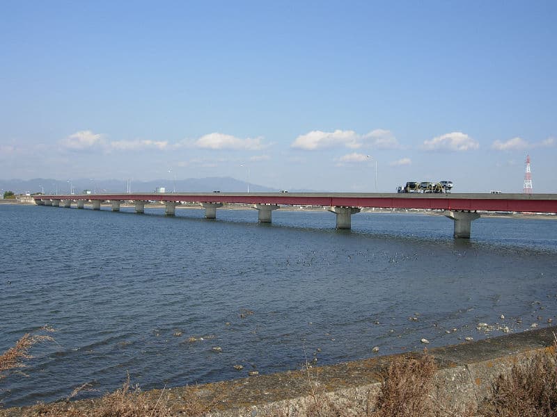
The Toyo River winds from the hills of eastern Aichi Prefecture down to Mikawa Bay, offering a calm corridor of farmland, reed beds, and small fishing communities. Its gentle flow and modest length make it ideal for unhurried exploration rather than dramatic adventure. Travelers seeking a quieter alternative to crowded Nagoya attractions find here a genuine slice of rural Japan shaped by the river’s seasonal rhythms.

Things to See and Do

Riverbank Paths and Cycling

Flat paths run along both banks for several kilometers, suitable for walking or renting a bicycle in nearby towns. Early morning visits reveal herons and egrets hunting in the shallows, while the wide sky provides open views toward the bay. In spring, scattered cherry trees line sections of the embankment; autumn brings golden rice fields that stretch to the water’s edge.

Fishing and Tidal Areas

Local anglers target sea-run trout and other species where the river meets brackish water. Visitors may observe traditional casting techniques or simply enjoy the peaceful sight of small boats heading out at dawn. The lower reaches near the estuary also support birdwatching, especially during migration periods when waders gather on exposed mudflats.

Nearby Villages and Markets

Short detours lead to roadside produce stands selling seasonal vegetables and dried seafood. The river has long supported agriculture and fishing communities, so modest shrines and old storehouses still stand along its course, offering glimpses of everyday Aichi life without the polish of major tourist sites.

Getting There

Reach the river by train to Toyohashi Station, then local bus or taxi to riverside access points. Renting a car provides more flexibility for following the river upstream into the hills or downstream to the bay. The area lies roughly 90 minutes by rail from central Nagoya, making it an easy day trip or quiet overnight stop.

Best Time to Visit

Late March through early April offers mild weather and blossoms, while October and November bring comfortable temperatures and harvest scenery. Summer can be humid and prone to sudden showers, and winter visits reward those prepared for cooler winds with empty paths and clear views of distant mountains.

Combining the Visit with Nearby Spots

Combine a river walk with a trip to the Irago Peninsula for coastal scenery or to the historic streets of nearby Yoshida Castle remnants. The river’s location also places it within reach of Mikawa Bay seafood restaurants and small onsen facilities that cater to travelers exploring eastern Aichi.

Visitor tips

  • Carry cash for small village shops and fishing permit fees, as card acceptance remains limited outside larger towns.
  • Wear sturdy shoes with good grip; riverbank paths can be muddy after rain and are not always paved.
  • Check local tide tables if planning time near the estuary, as water levels and bird activity change noticeably with the bayu2019s tides.

Frequently asked questions

Is the Toyo River suitable for swimming?+

Swimming is not recommended. The river has strong tidal influence near the bay and variable currents upstream; locals use it mainly for fishing and irrigation.

Are there guided tours available along the Toyo River?+

Formal tours are rare. Independent exploration by foot or bicycle is the norm; some local fishing cooperatives occasionally offer informal introductions for interested visitors.

What kind of wildlife can I expect to see?+

Common sightings include grey herons, little egrets, kingfishers, and seasonal migratory shorebirds near the estuary. Carp and mullet are visible in clearer stretches of water.

How far upstream can I comfortably travel on foot or by bike?+

Most visitors stay within the flat 10u201315 km stretch from the estuary toward the first major bridges. Beyond that the terrain rises and paths become narrower and less maintained.

Are there any seasonal events connected to the river?+

Small local festivals occur in spring and autumn at riverside shrines, featuring mikoshi processions and food stalls. Dates vary yearly and are announced primarily through community notice boards.

Share
Google Maps Apple Maps Directions

Image: Darklanlan · Public domain · via Wikimedia Commons

Keep reading

Nearby & related

All stories
M
Aichi Prefecture

Morizo & Kikkoro Statue: Aichi’s Enduring World Expo Mascots

Discover the whimsical Morizo and Kikkoro statues in Aichi Prefecture, lasting symbols of the 2005 Expo’s celebration of…

19 August 2026
預
Aichi Prefecture

預り渕ポットホール: Japan’s Dramatic River-Carved Pothole Viewpoint in Aichi

Stand above the massive swirling pothole formed by centuries of river erosion in the mountains of Aichi Prefecture.

19 August 2026
H
Aichi Prefecture

Hassoyama Panorama Observatory: Sweeping Views Across Aichi’s Countryside

Climb to this hilltop viewpoint in Aichi Prefecture for uninterrupted panoramas of mountains, valleys, and distant city…

19 August 2026