Skip to content
Plan & Tour
DestinationsItinerariesTravel BlogAboutContact
0Sign inPlan a trip
Plan & TourPlan & Tour

Travel guides, destination inspiration and curated itineraries for Canada, the USA and beyond, plus a free tool to plan your own day-by-day trip.

Get travel inspiration

Explore

  • All Destinations
  • Curated Itineraries
  • Travel Blog
  • Plan a Trip

Topics

  • Hiking & Nature
  • Food & Drink
  • City Breaks
  • Budget Travel

Company

  • About Us
  • Contact
  • Privacy Policy
  • Terms of Service

© 2026 Plan & Tour. Built for travellers.

Discover the world, one trip at a time.

Puig de l’Àguila: Hiking Mallorca’s Quiet Northeastern Peak
  1. Home
  2. Destinations
  3. Balearic Islands
  4. Puig de l’Àguila: Hiking Mallorca’s Quiet Northeastern Peak
Mountain

Puig de l’Àguila: Hiking Mallorca’s Quiet Northeastern Peak

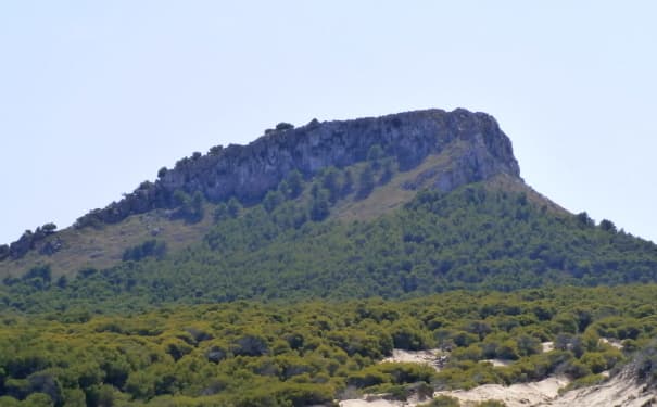
A rewarding climb through pine woods to panoramic views over the Llevant coast and Cap de Pera.

Balearic IslandsUpdated 21 September 2026

Why Puig de l’Àguila Stands Out

Unlike the crowded summits of the Tramuntana, Puig de l’Àguila rises gently from the rolling hills east of Artà. Its modest height delivers sweeping 360-degree views across the Bay of Alcúdia, the rugged Cap de Pera peninsula, and the open Mediterranean. The trail passes through fragrant pine forest and Mediterranean scrub that changes color with the seasons, offering a quieter alternative to more famous Mallorcan hikes.

How to Get There

The mountain sits in the municipality of Artà. Most visitors drive from Palma via the Ma-12 and Ma-15 roads, a journey of about 75 minutes. Park at the signed trailhead near the Coll de sa Font, a short distance south of the village of Artà. No public transport reaches the starting point, so a rental car or taxi is required. From the parking area a clear path climbs steadily through holm oaks and pines.

The Hiking Route

The out-and-back trail covers roughly 6 km with 300 m of elevation gain. Allow two to three hours round-trip for a comfortable pace with photo stops. The route is well-marked with occasional cairns and wooden signposts. Near the summit a small stone refuge offers shelter from wind. On clear days the island of Menorca is visible on the northern horizon.

Best Time to Visit

Spring (March–May) and autumn (September–November) provide mild temperatures and fewer visitors. Summer hikes are possible but start early to avoid midday heat. Winter days can be crisp and clear, though occasional rain makes the path slippery. Always check the local forecast before setting out, as the exposed summit offers little shade.

Nearby Attractions

  • The historic center of Artà with its weekly market and hilltop sanctuary.
  • Coves d’Artà, dramatic limestone caverns just 15 minutes by car.
  • The coastal path from Cala Ratjada to Cap de Pera lighthouse for a seaside contrast to the mountain hike.
  • The medieval village of Capdepera and its restored castle.

Combining the Puig de l’Àguila hike with a visit to one of these sites makes an excellent full-day itinerary.

Visitor tips

  • Wear sturdy walking shoes and carry at least 1.5 liters of water per person; there are no refill points on the trail.
  • Start early in the morning to enjoy cooler temperatures and softer light for photography at the summit.
  • Download an offline map; mobile signal can be weak once you leave the main road.

Frequently asked questions

How difficult is the hike to Puig de l'u00c0guila?+

The trail is moderate and suitable for most reasonably fit walkers. There is no technical climbing, but the final section is steep and rocky.

Are dogs allowed on the trail?+

Yes, dogs are permitted provided they remain under control and owners clean up after them.

Is there any shade or water on the route?+

Shade is limited once you leave the pine forest. Carry all the water you need; no springs are available along the path.

Can I cycle to the summit?+

The lower sections are rideable on a mountain bike, but the upper rocky trail is best walked. Most cyclists leave bikes at the forest edge.

What should I do if the weather turns bad?+

Descend immediately. The summit is exposed and lightning risk is real during summer storms. The trail can become slippery after rain.

Share
Google Maps Apple Maps Directions

Image: Olaf Meister · CC BY-SA 4.0 · via Wikimedia Commons

Keep reading

Nearby & related

All stories
T
Balearic Islands

The Statue of James I of Aragon in Palma de Mallorca

Stand before the bronze monument to the king who conquered Mallorca and shaped the island’s medieval identity.

26 September 2026
M
Balearic Islands

Mirador del Centenari del Foment: Panoramic Views Over Mallorca’s Tramuntana Mountains

This secluded viewpoint delivers sweeping vistas of rugged peaks, olive terraces, and the Mediterranean from the heart…

26 September 2026
M
Balearic Islands

Mirador des Salt de la Bella Dona: Dramatic Cliffside Views in Mallorca’s Tramuntana

This secluded viewpoint reveals plunging gorges, terraced valleys, and distant sea horizons in the heart of the Serra de…

26 September 2026