Skip to content
Plan & Tour
DestinationsItinerariesTravel BlogAboutContact
0Sign inPlan a trip
Plan & TourPlan & Tour

Travel guides, destination inspiration and curated itineraries for Canada, the USA and beyond, plus a free tool to plan your own day-by-day trip.

Get travel inspiration

Explore

  • All Destinations
  • Curated Itineraries
  • Travel Blog
  • Plan a Trip

Topics

  • Hiking & Nature
  • Food & Drink
  • City Breaks
  • Budget Travel

Company

  • About Us
  • Contact
  • Privacy Policy
  • Terms of Service

© 2026 Plan & Tour. Built for travellers.

Discover the world, one trip at a time.

Neto River: Calabria’s Wild Waterway Through Ancient Valleys
  1. Home
  2. Destinations
  3. Calabria
  4. Neto River: Calabria’s Wild Waterway Through Ancient Valleys
River

Neto River: Calabria’s Wild Waterway Through Ancient Valleys

Follow the longest river in Calabria from its Sila mountain source to the Ionian Sea for hiking, rafting, and quiet natural immersion.

CalabriaUpdated 17 October 2026

Why the Neto River Stands Out

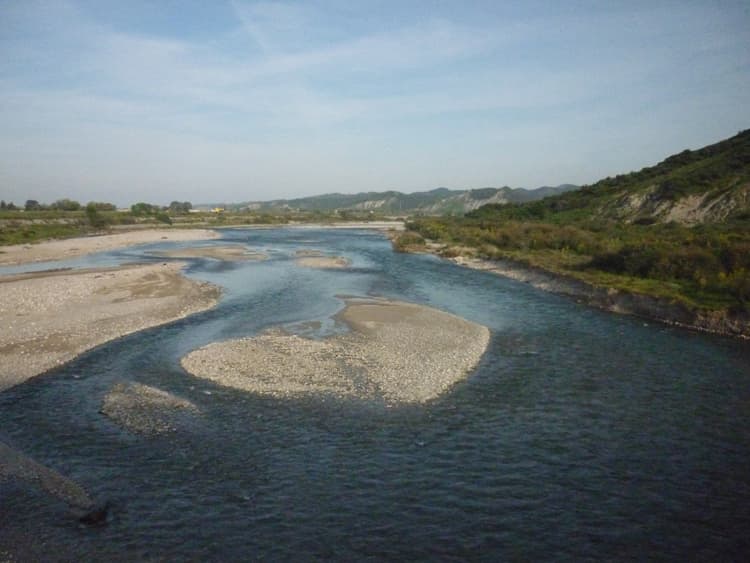
The Neto River carves through central Calabria for nearly 100 kilometers, rising in the beech forests of the Sila Greca and emptying into the Ionian Sea near Cirò Marina. Its clear, fast-moving waters and steep limestone gorges create a landscape that feels remote even in well-traveled southern Italy. Unlike more commercialized rivers farther north, the Neto remains largely undeveloped, offering visitors a genuine sense of wilderness within easy reach of historic towns.

Things to See and Do

Water Activities

Early spring brings reliable water levels for rafting and kayaking through the mid-valley sections between the towns of San Giovanni in Fiore and Cotronei. Local outfitters run half-day trips that pass under dramatic cliffs and through narrow canyons where the river narrows to a few meters. Swimmers favor the calmer pools near the lower reaches in summer, where smooth river stones and shallow stretches make for safe wading.

Hiking and Nature

Marked trails follow the riverbanks through mixed oak and pine woods. One rewarding walk starts near the village of Petilia Policastro and descends to the riverbed, passing old stone bridges and abandoned water mills. Birdwatchers often spot kingfishers and grey herons along the quieter bends. The surrounding hills support chestnut groves that produce sweet fruit in autumn.

Getting There

The most practical base is Crotone on the coast or the inland town of Cotronei. From Crotone, a short drive northwest on the SS106 and then provincial roads leads to several river access points. Visitors without a car can take regional buses to Strongoli or Cirò and arrange local transfers. The nearest airports are Lamezia Terme and Crotone, both roughly an hour away by road.

Best Time to Visit

April through June offers the best balance of flowing water for activities and mild temperatures for hiking. September and early October bring fewer visitors and warm swimming weather. Avoid July and August when the upper valley can become extremely hot and the lower river levels drop. Winter visits are possible for photography but require checking for flash-flood risk after heavy rains.

Nearby Attractions

Combine a Neto visit with the archaeological park at Capo Colonna outside Crotone, the ancient Greek site of Kroton. The wine route around Cirò produces the region’s famous Gaglioppo reds, and tastings are available at family estates in the hills above the river mouth. Further inland, the Sila National Park offers cooler forest walks and the chance to see wolves and wild boar in their natural habitat.

Visitor tips

  • A rental car is essential for reaching multiple access points; public transport is limited once you leave the main coastal road.
  • Bring sturdy water shoes or sandals with good grip, as riverbed rocks are slippery and often sharp.
  • Check local weather and river conditions the day before any water activity; sudden thunderstorms in the Sila can raise water levels quickly.

Frequently asked questions

Can you swim in the Neto River?+

Yes, in the calmer lower sections during summer. Stronger currents in the upper gorges make swimming unsafe outside organized rafting trips.

Are there guided tours on the Neto?+

Local operators in Cotronei and Petilia Policastro offer rafting and kayaking excursions from spring through autumn; advance booking is recommended on weekends.

How far is the Neto River from Crotone?+

The nearest river access points lie 25u201340 minutes inland by car from Crotone, depending on which stretch you choose.

Is the area around the Neto River good for hiking?+

Yes. Several marked trails follow the valley and connect to the surrounding hills, with varying lengths suitable for half-day or full-day walks.

What should I bring for a day at the Neto River?+

Pack water, sun protection, sturdy footwear, and a dry bag for electronics. Insect repellent is useful near the riverbanks in summer.

Share
Google Maps Apple Maps Directions

Image: Beppeveltri · CC BY-SA 3.0 · via Wikimedia Commons

Keep reading

Nearby & related

All stories
S
Calabria

Silos Archaeological Site: Ancient Ruins in Coastal Calabria

Explore the layered history and quiet coastal setting of Silos, an archaeological site near Crotone that preserves…

18 October 2026
C
Calabria

Cannoni Archaeological Site: Ancient Ruins in Calabria’s Heartland

Wander the weathered remains of Cannoni, an evocative archaeological site near Crotone revealing layers of ancient…

18 October 2026
T
Calabria

Torrionetto Archaeological Site: Calabria’s Quiet Window into Ancient Magna Graecia

Trace layers of Greek and Roman history at this compact, coastal ruin near Crotone.

18 October 2026