
Skip to content
Plan & Tour
DestinationsItinerariesTravel BlogAboutContact
0Sign inPlan a trip
Plan & TourPlan & Tour

Travel guides, destination inspiration and curated itineraries for Canada, the USA and beyond, plus a free tool to plan your own day-by-day trip.

Get travel inspiration

Explore

  • All Destinations
  • Curated Itineraries
  • Travel Blog
  • Plan a Trip

Topics

  • Hiking & Nature
  • Food & Drink
  • City Breaks
  • Budget Travel

Company

  • About Us
  • Contact
  • Privacy Policy
  • Terms of Service

© 2026 Plan & Tour. Built for travellers.

Discover the world, one trip at a time.

Muela del Diablo: Hiking Bolivia’s Striking Rock Formation Near La Paz
  1. Home
  2. Destinations
  3. La Paz Department
  4. Muela del Diablo: Hiking Bolivia’s Striking Rock Formation Near La Paz
Mountain

Muela del Diablo: Hiking Bolivia’s Striking Rock Formation Near La Paz

A distinctive volcanic plug south of La Paz, Muela del Diablo rewards hikers with sweeping high-Andean views and an easy escape from the city.

La Paz DepartmentUpdated 12 October 2026

Why Visit Muela del Diablo

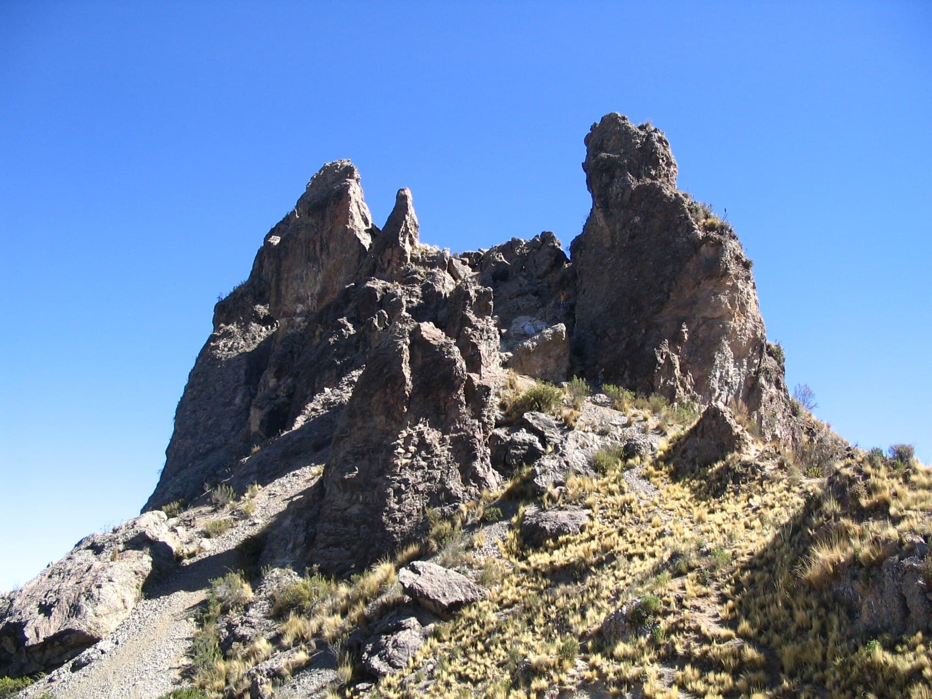
Rising abruptly from the Altiplano, Muela del Diablo is a 3,700-metre volcanic plug whose sheer rock face gives the mountain its name, “Devil’s Tooth.” The short but steep hike to its base and surrounding ridges delivers unobstructed panoramas of La Paz, the snow-capped Illimani massif, and the sprawling valley below. Because the trail starts at the city’s southern edge, visitors can reach the summit area in half a day and still return before afternoon winds pick up.

Getting There

From central La Paz, take a micro or minibus marked “Mallasa” or “Ovejuyo” from the Prado or Plaza Belzu and ride to the southern suburb of Mallasa. At the main plaza, shared taxis or moto-taxis continue a few kilometres along the unpaved road that skirts the mountain’s western flank. Ask to be dropped at the obvious trailhead near the small village of Mallasilla. The final approach is on foot; the path is well-trodden and requires no technical equipment for the standard route.

What to See and Do

The classic outing is the 90-minute ascent to the saddle below the main tooth, where the city skyline and distant cordillera appear in one frame. Photographers often continue along the ridge for another 30 minutes to reach a secondary viewpoint overlooking the dried riverbed of the Río Choqueyapu. Rock climbers tackle the east face via bolted routes, while casual visitors simply picnic on the grassy slopes. At dawn the rock glows deep red; at sunset the lights of La Paz twinkle below.

Best Time to Visit

The dry season from May to October brings clear skies and stable trails. July and August are busiest; shoulder months of May and September offer fewer people and milder midday temperatures. Rainy-season visits (November–March) are possible but require waterproof layers and awareness of slippery clay sections.

Nearby Attractions

  • Valle de la Luna’s eroded badlands lie only 15 minutes by taxi from Mallasa.
  • The botanical gardens and colonial church of San Pedro de Mallasa make a pleasant stop on the return.
  • Further south, the pre-Inca ruins of Tiwanaku can be combined into a full-day outing.

Visitor tips

  • Carry at least two litres of water; there are no reliable sources on the trail.
  • Wear sturdy shoes with good gripu2014loose gravel covers much of the upper path.
  • Start early to avoid the strong afternoon winds that sweep across the ridge.

Frequently asked questions

How difficult is the hike to Muela del Diablo?+

The standard trail is moderate: 400 m of elevation gain over 2u20133 km. Most fit walkers complete the round trip in three hours.

Do I need a guide or special equipment?+

No technical gear is required for the hiking route. A guide is useful only if you plan to rock-climb the east face or want deeper geological commentary.

Is Muela del Diablo safe for solo travellers?+

The area is popular with local hikers on weekends. Weekdays are quieter; stick to the main path and inform someone of your plans.

Can I camp at the mountain?+

Informal camping is possible on the lower grassy slopes, but there are no facilities. Most visitors return to La Paz the same day.

What should I bring besides water?+

Sun protection, a light wind jacket, and a basic snack. Binoculars are handy for spotting distant peaks.

Share
Google Maps Apple Maps Directions

Image: No machine-readable author provided. Anakin~commonswiki assumed (based on copyright claims). · CC BY-SA 3.0 · via Wikimedia Commons

Keep reading

Nearby & related
All stories
La Paz River: Rafting and Canyon Adventures in Bolivia
La Paz Department

La Paz River: Rafting and Canyon Adventures in Bolivia

Follow the La Paz River through Andean canyons from the highlands into the Yungas for rafting, scenery, and cultural…

13 October 2026
L
La Paz Department

Leque River: Bolivia’s Andean Waterway in La Paz Department

Follow the clear waters of the Leque River through rugged valleys and quiet Aymara communities in Bolivia’s La Paz…

13 October 2026
B
La Paz Department

Boopi River: Bolivia’s Wild Waterway in La Paz Department

A biodiverse river valley offering jungle hikes, wildlife viewing, and authentic Amazonian experiences near La Paz.

13 October 2026