Skip to content
Plan & Tour
DestinationsItinerariesTravel BlogAboutContact
0Sign inPlan a trip
Plan & TourPlan & Tour

Travel guides, destination inspiration and curated itineraries for Canada, the USA and beyond, plus a free tool to plan your own day-by-day trip.

Get travel inspiration

Explore

  • All Destinations
  • Curated Itineraries
  • Travel Blog
  • Plan a Trip

Topics

  • Hiking & Nature
  • Food & Drink
  • City Breaks
  • Budget Travel

Company

  • About Us
  • Contact
  • Privacy Policy
  • Terms of Service

© 2026 Plan & Tour. Built for travellers.

Discover the world, one trip at a time.

Mount Robson Provincial Park: Hiking to the Highest Peak in the Canadian Rockies
  1. Home
  2. Destinations
  3. Alberta
  4. Mount Robson Provincial Park: Hiking to the Highest Peak in the Canadian Rockies
Protected area

Mount Robson Provincial Park: Hiking to the Highest Peak in the Canadian Rockies

Experience dramatic alpine scenery, world-class trails, and the iconic Berg Lake beneath Mount Robson in Alberta's protected wilderness.

AlbertaUpdated 16 August 2026

Why Visit Mount Robson Provincial Park

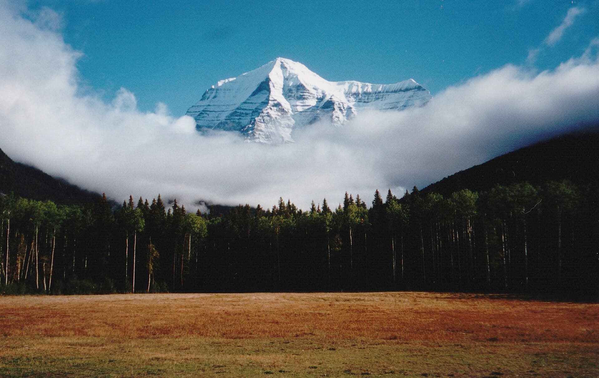
Mount Robson Provincial Park protects the highest summit in the Canadian Rockies, a 3,954-metre pyramid of rock and ice that dominates the skyline along the Yellowhead Highway. The park forms the western gateway to the Canadian Rocky Mountain Parks UNESCO World Heritage Site and offers visitors an accessible yet wild introduction to the region’s glaciated peaks, turquoise lakes, and dense conifer forests.

Signature Experiences

Berg Lake Trail

The park’s premier hike follows the Robson River through old-growth forest before climbing steadily past Whitehorn Falls and the Emperor Falls viewpoint. The trail ends at Berg Lake, where chunks of ice calve from the Robson Glacier into the water, creating a constantly changing foreground for the mountain. Most visitors spend two to three days on this out-and-back route, staying at designated campgrounds along the way.

Shorter Walks and Viewpoints

Those with limited time can reach Kinney Lake in a few hours or enjoy the easy Overlander Trail along the Fraser River. The Mount Robson Viewpoint pullout on Highway 16 provides a classic roadside photograph of the peak on clear days.

Getting There

The park lies along the Yellowhead Highway (Highway 16) between Jasper, Alberta, and Valemount, British Columbia. Most travelers arrive by car from Jasper (roughly 80 km east) or from the west via Prince George. Limited shuttle services operate from Jasper during peak season for hikers without vehicles.

Best Time to Visit

July through September offers the most reliable trail conditions and longest daylight. Early summer brings high water in creeks, while September often delivers the first light snow on the peaks and fewer mosquitoes. Winter visits are possible for snowshoeing or cross-country skiing near the highway, but avalanche risk closes the Berg Lake Trail.

Wildlife and Safety

Black bears, grizzlies, moose, and mountain goats frequent the area. Travel in groups, make noise on trails, and store food properly at campgrounds. The park’s remote character means visitors should carry the ten essentials and be prepared for rapid weather changes even in midsummer.

Nearby Destinations

Continuing east brings travelers into Jasper National Park and its famous Maligne Lake and Columbia Icefield. Westward, the highway descends into the Robson Valley, known for its extensive trail network in the ancient inland rainforest of the Ancient Forest and the scenic lakes around McBride.

Visitor tips

  • Reserve backcountry campsites well ahead; spaces on the Berg Lake Trail fill quickly during July and August.
  • Carry bear spray and know how to use it; both black and grizzly bears are active throughout the park.
  • Check current trail and weather conditions at the visitor centre in Mount Robson village before setting out on longer hikes.

Frequently asked questions

How difficult is the Berg Lake Trail?+

The 22-kilometre trail to Berg Lake gains about 800 metres of elevation and is rated moderate to strenuous. Most fit hikers complete it in two days each way, though many choose to spend three nights along the route.

Do I need a vehicle to visit the park?+

A car is the most practical way to reach trailheads and viewpoints. Limited seasonal shuttles run from Jasper for hikers, but public transport options are otherwise minimal.

What wildlife am I likely to see?+

Black bears, grizzlies, moose, marmots, and mountain goats are commonly sighted. Early morning and evening offer the best chances for viewing along the trails and river corridors.

Are there frontcountry camping options?+

Yes, Robson Meadows and Robson River campgrounds provide vehicle-accessible sites near the highway with basic facilities. These serve as convenient bases for day hikes and park exploration.

Can I see Mount Robson without hiking?+

Several roadside pullouts along Highway 16 offer excellent views of the mountain on clear days, and the visitor centre area provides interpretive displays and short walks.

Share
Google Maps Apple Maps Directions

Visitor info

Official website

Contact info via Wikidata

Image: Wofratz on German Wikipedia · CC BY-SA 2.5 · via Wikimedia Commons

Keep reading

Nearby & related

All stories
M
Alberta

Marmot 2: Hiking Alberta’s Quiet Rocky Mountain Summit

Discover the uncrowded trails, alpine meadows, and sweeping views from Marmot 2 in Jasper National Park.

16 August 2026
J
Alberta

Jasper Planetarium: Immersive Astronomy Under Alberta’s Darkest Skies

Experience the cosmos in one of Canada’s premier dark-sky locations at the Jasper Planetarium.

16 August 2026
T
Alberta

The Palisade: Hiking the Iconic Mountain in Jasper National Park

Discover panoramic Rocky Mountain views and accessible trails at The Palisade, a striking peak near Jasper, Alberta.

16 August 2026