Skip to content
Plan & Tour
DestinationsItinerariesTravel BlogAboutContact
0Sign inPlan a trip
Plan & TourPlan & Tour

Travel guides, destination inspiration and curated itineraries for Canada, the USA and beyond, plus a free tool to plan your own day-by-day trip.

Get travel inspiration

Explore

  • All Destinations
  • Curated Itineraries
  • Travel Blog
  • Plan a Trip

Topics

  • Hiking & Nature
  • Food & Drink
  • City Breaks
  • Budget Travel

Company

  • About Us
  • Contact
  • Privacy Policy
  • Terms of Service

© 2026 Plan & Tour. Built for travellers.

Discover the world, one trip at a time.

Hiking Hacha Grande: Lanzarote’s Southern Volcanic Summit
  1. Home
  2. Destinations
  3. Yaiza
  4. Hiking Hacha Grande: Lanzarote’s Southern Volcanic Summit
Mountain

Hiking Hacha Grande: Lanzarote’s Southern Volcanic Summit

Ascend Hacha Grande in Yaiza for sweeping views of Lanzarote’s lava fields, coast, and distant volcanoes.

YaizaUpdated 12 November 2026

Why Hacha Grande Stands Out

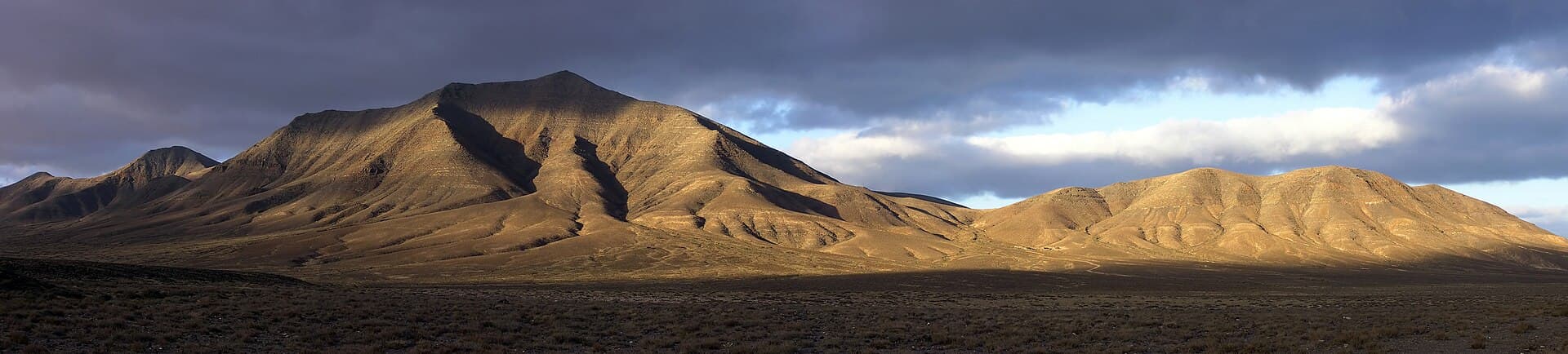
Hacha Grande rises as a prominent volcanic peak in southern Lanzarote, offering hikers a moderate challenge and 360-degree panoramas that stretch from the Atlantic coast to the Timanfaya lava fields and the island’s central mountains. Its dark basalt slopes and sparse vegetation highlight the island’s dramatic geology, making the summit a rewarding vantage point rather than a crowded tourist stop.

Reaching the Trailhead

Drivers approach from the town of Yaiza via the LZ-702 road toward the coast, parking near the base where a clear path begins. No public transport serves the immediate trailhead, so a rental car or taxi from Playa Blanca provides the most practical access. The short drive passes through agricultural plains and scattered volcanic cones that preview the landscape ahead.

The Hike and Summit Experience

The ascent follows a well-defined, rocky trail that gains elevation steadily over roughly two kilometers. Expect loose gravel and occasional steep sections; the route rewards steady pacing with ever-widening views of the Papagayo beaches to the south and the rugged interior to the north. At the top, a small cairn marks the high point where visitors can rest and photograph the contrast between green coastal plains and black lava badlands.

What to Carry

  • At least two liters of water per person, as shade is nonexistent.
  • Sturdy hiking shoes with good grip on loose rock.
  • Sun protection including a wide-brim hat and high-SPF sunscreen.
  • A light wind layer, since breezes strengthen near the summit.

Best Time to Visit

Winter and early spring bring milder temperatures and clearer skies, ideal for the exposed hike. Summer visits require an early start to avoid midday heat. Avoid the trail after heavy rain, when surfaces become slippery.

Nearby Places Worth Combining

After descending, continue south to the beaches of Papagayo or explore the lava landscapes of Timanfaya National Park, both within a short drive. The village of Yaiza itself offers traditional Canarian restaurants and a peaceful contrast to the mountain’s stark terrain.

Visitor tips

  • Start early to avoid strong afternoon winds and secure parking near the trailhead.
  • Download an offline map; mobile coverage can drop on the upper slopes.
  • Respect the terrain by staying on the marked path to protect fragile volcanic soil.

Frequently asked questions

How difficult is the hike to Hacha Grande?+

The trail is moderate, with steady elevation gain and loose rock; most fit hikers complete it in two to three hours round-trip.

Is Hacha Grande suitable for children?+

Older children accustomed to hiking on uneven ground can manage the route, but the lack of shade and steep sections make it less ideal for very young kids.

Are there facilities at the trailhead or summit?+

No restrooms, water, or shelters exist; visitors must be fully self-sufficient with supplies and waste removal.

Can you see the ocean from the summit?+

Yes, clear days reveal the Atlantic coastline and the white sands of Papagayo beaches to the south.

What should I wear for the hike?+

Layered clothing, sturdy boots, and strong sun protection are essential; temperatures can feel cooler at the exposed summit.

Share
Google Maps Apple Maps Directions

Image: Yummifruitbat · CC BY-SA 2.5 · via Wikimedia Commons

Keep reading

Nearby & related

All stories
Playa Quemada: Lanzarote’s Quiet Volcanic Beach Retreat
Yaiza

Playa Quemada: Lanzarote’s Quiet Volcanic Beach Retreat

A low-key black-sand cove on Lanzarote’s southwest coast offering calm swimming and local character away from the main…

12 November 2026
Caldera Riscada: Hiking Lanzarote’s Striking Volcanic Crater in Yaiza
Yaiza

Caldera Riscada: Hiking Lanzarote’s Striking Volcanic Crater in Yaiza

Explore the dramatic rim and interior of Caldera Riscada for sweeping views over Lanzarote’s volcanic heartland.

12 November 2026
Monte Roja: Hiking Lanzarote’s Striking Red Volcano in Yaiza
Yaiza

Monte Roja: Hiking Lanzarote’s Striking Red Volcano in Yaiza

Climb the vivid red slopes of Monte Roja for sweeping volcanic views across Lanzarote’s Yaiza municipality.

12 November 2026