
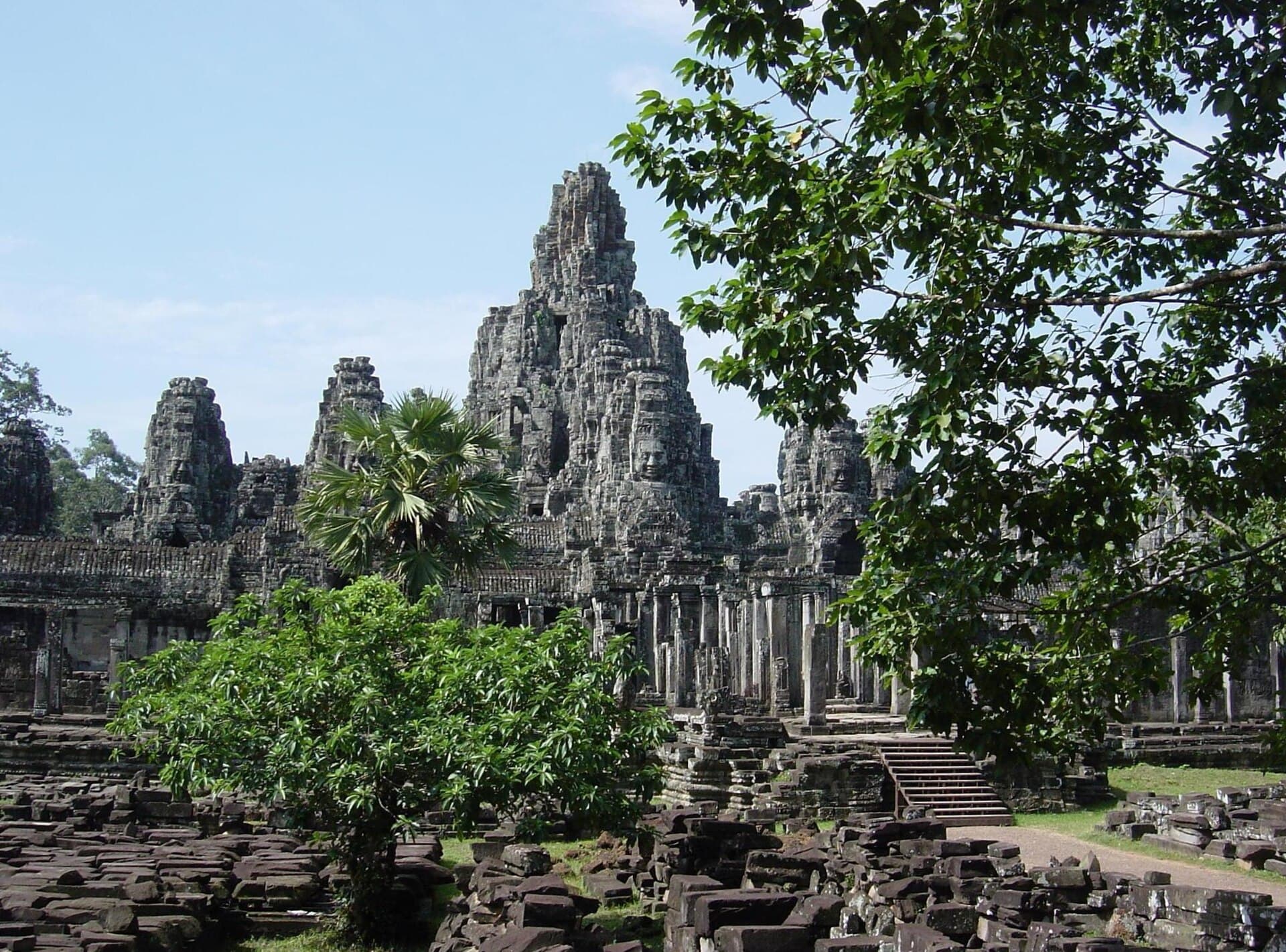
Angkor Thom: The Monumental Last Capital of the Khmer Empire
Explore the vast walled city of Angkor Thom, where towering gates, serene stone faces, and intricate bas-reliefs reveal the grandeur of 12th-century Cambodia.
History and Significance
Angkor Thom stands as the final and largest capital of the Khmer Empire, constructed in the late 12th century by King Jayavarman VII. Enclosed by an 8-kilometer moat and 12-meter-high laterite walls, the city once housed up to one million residents and served as the political and religious heart of the empire. Its design reflects a blend of Hindu and Buddhist influences, with the central Bayon temple symbolizing Mount Meru at the universe’s center.
What to See and Do
Begin at the South Gate, where four serene faces gaze in cardinal directions above the causeway lined with stone nagas and demons. Inside, the Bayon’s 54 towers feature over 200 carved faces believed to represent the king or Avalokiteshvara. Walk the Terrace of the Elephants to admire detailed carvings of elephants and warriors, then visit the Terrace of the Leper King for intricate mythological scenes.
Key Structures Within the Walls
- Baphuon: A massive temple-mountain restored through an innovative jigsaw-puzzle method, offering sweeping views from its upper levels.
- Phimeanakas: A small pyramid temple once reserved for royalty, connected by raised walkways.
- Preah Palilay: A quiet Buddhist sanctuary surrounded by mature trees, ideal for peaceful exploration.
Allow at least three hours to wander the central area on foot, as the scale rewards slow pacing and repeated viewing of the bas-reliefs depicting daily life, battles, and Hindu epics.
Getting There
Angkor Thom lies 1.5 kilometers north of Angkor Wat within the Angkor Archaeological Park. Most visitors arrive by tuk-tuk, bicycle, or organized tour from Siem Reap, 6 kilometers south. The park’s main entrance road leads directly to the South Gate; purchase the required temple pass before entering the complex.
Best Time to Visit
The dry season from November to February offers cooler temperatures and clearer skies, ideal for extended outdoor exploration. Early morning visits reduce heat and crowds, while late afternoon light enhances the stone carvings. Avoid the peak of the rainy season when paths can become muddy and some inner structures are harder to access.
Nearby Attractions
Angkor Thom connects seamlessly to other major sites. A short walk or ride north reaches Ta Prohm with its iconic tree roots, while east lies the massive reservoir of the East Baray. Many travelers combine a visit with Preah Khan or the Roluos group temples south of Siem Reap for a full day of Khmer architecture.
Visitor tips
- Wear sturdy shoes with good grip, as stone surfaces inside the temples are uneven and can be slippery during the rainy season.
- Carry plenty of water and a hat; shaded areas are limited and temperatures rise quickly even in the cooler months.
- Hire a licensed local guide for at least the central Bayon area to understand the symbolic meaning behind the face towers and bas-reliefs.
Frequently asked questions
How large is Angkor Thom compared to Angkor Wat?
Angkor Thom covers roughly 9 square kilometers inside its walls, making it significantly larger in area than the single temple of Angkor Wat, though the density of structures differs.
Can I visit Angkor Thom without a guide?
Yes, the site is well signposted and many visitors explore independently using maps or audio guides available at the park entrance.
Is Angkor Thom suitable for children?
The open spaces and wide causeways make it accessible, but the uneven stones and heat require careful supervision and frequent breaks.
What is the best way to photograph the face towers?
Approach the Bayon from the east in the morning for softer light, and climb the upper terraces carefully for closer views of the carved faces.
Are there restrooms and food options inside Angkor Thom?
Basic facilities exist near the South Gate and central areas, but most visitors bring snacks or return to Siem Reap for meals.